 |
|
Clay Center Municipal Airport |
Coordinates: 39°23â²14â³N 097°09â²26â³W / 39.38722°N 97.15722°W / 39.38722; -97.15722
| Clay Center Municipal Airport |
| IATA: none â ICAO: KCYW â FAA LID: CYW |
| Summary |
| Airport type |
Public |
| Owner |
City of Clay Center |
| Serves |
Clay Center, Kansas |
| Elevation AMSL |
1,208 ft / 368 m |
| Runways |
| Direction |
Length |
Surface |
| ft |
m |
| 17/35 |
4,199 |
1,280 |
Asphalt |
| Statistics (2007) |
| Aircraft operations |
24,000 |
| Based aircraft |
16 |
| Source: Federal Aviation Administration |
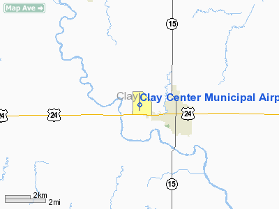
Clay Center Municipal Airport (ICAO: KCYW, FAA LID: CYW) is a city-owned public-use airport located two miles (3 km) west of the central business district of Clay Center, a city in Clay County, Kansas, United States.
Although most U.S. airports use the same three-letter location identifier for the FAA and IATA, Clay Center Municipal Airport is assigned CYW by the FAA but has no designation from the IATA.
Facilities and aircraft
Clay Center Municipal Airport covers an area of 158 acres (64 ha) which contains one asphalt paved runway (17/35) measuring 4,199 x 75 ft (1,280 x 23 m). For the 12-month period ending September 26, 2007, the airport had 24,000 aircraft operations, an average of 65 per day: 92% general aviation and 8% military. At that time there were 16 aircraft based at this airport: 88% single-engine and 12% multi-engine.
The above content comes from Wikipedia and is published under free licenses – click here to read more.
|
Location &
QuickFacts
|
FAA
Information Effective: |
2008-06-05 |
|
Airport
Identifier: |
CYW |
|
Airport
Status: |
Operational |
|
Longitude/Latitude: |
097-09-25.9710W/39-23-13.7000N
-97.157214/39.387139 (Estimated) |
|
Elevation: |
1208 ft / 368.20 m (Surveyed) |
|
Land: |
158 acres |
|
From
nearest city: |
2 nautical miles W of Clay Center, KS |
|
Location: |
Clay County, KS |
|
Magnetic Variation: |
07E (1985) |
Owner & Manager
|
Ownership: |
Publicly owned |
|
Owner: |
City Of Clay Center |
|
Address: |
427 Court St.
Clay Center, KS 67432 |
|
Phone
number: |
785-632-5454 |
|
Manager: |
Mike Spicer...fbo |
|
Address: |
1207 18th Rd
Clay Center, KS 67432 |
|
Phone number: |
785-632-3217 |
Airport Operations and Facilities
|
Airport
Use: |
Open to public |
|
Wind
indicator: |
Yes |
|
Segmented Circle: |
Yes |
|
Control
Tower: |
No |
|
Lighting
Schedule: |
DUSK-DAWN
RY 17/35 MIRL PRESET LOW INTST DUSK-2200; TO INCR INTST ACTVT - CTAF.
AFT 2200 ACTVT - CTAF. |
|
Beacon
Color: |
Clear-Green (lighted land airport) |
|
Landing
fee charge: |
No |
|
Sectional chart: |
Wichita |
|
Region: |
ACE - Central |
|
Traffic
Pattern Alt: |
800 ft |
|
Boundary
ARTCC: |
ZKC - Kansas City |
|
Tie-in
FSS: |
ICT - Wichita |
|
FSS on
Airport: |
No |
|
FSS Toll
Free: |
1-800-WX-BRIEF |
|
NOTAMs
Facility: |
ICT (NOTAM-d service avaliable) |
|
Federal Agreements: |
NGY |
Airport Communications
|
CTAF: |
122.800 |
|
Unicom: |
122.800 |
Airport Services
|
Fuel
available: |
100LLMOGAS |
|
Airframe
Repair: |
MAJOR |
|
Power
Plant Repair: |
MAJOR |
|
Bottled
Oxygen: |
NONE |
|
Bulk
Oxygen: |
NONE |
|
Runway Information
Runway 17/35
|
Dimension: |
4199 x 75 ft / 1279.9 x 22.9 m |
|
Surface: |
ASPH, Fair Condition
EXHIBITS CRACKING WITH AREAS OF SPALLING & POTHOLES. |
|
Weight Limit: |
Single wheel: 12000 lbs.
Dual wheel: 15000 lbs. |
|
Edge Lights: |
Medium
ALL RY 17 THLD LIGHTS & NUMEROUS RY EDGE LIGHTS HAVE BEEN DAMAGED OR
DESTROYED. VIGILANCE SHOULD BE EXERCISED WHEN USING THIS RY UNDER ADVERSE
WEATHER OR NIGHTIME CONDITIONS. |
|
|
Runway 17
|
Runway 35
|
|
Longitude: |
097-09-25.3500W |
097-09-26.5900W |
|
Latitude: |
39-23-34.4450N |
39-22-52.9560N |
|
Elevation: |
1208.00 ft |
1206.00 ft |
|
Alignment: |
127 |
1 |
|
Traffic
Pattern: |
Left |
Left |
|
Markings: |
Numbers only, Poor Condition
RY NUMBERS & NPI MARKINGS ARE BADLY FADED. |
Numbers only, Poor Condition
RY NUMBERS & NPI MARKINGS ARE BADLY FADED. |
|
Obstruction: |
, 50:1 slope to clear |
15 ft road, 465.0 ft from runway, 17:1 slope to clear |
|
Radio Navigation Aids
|
ID |
Type |
Name |
Ch |
Freq |
Var |
Dist |
|
CYW |
NDB |
Clay Center |
|
362.00 |
07E |
0.4 nm |
|
DBX |
NDB |
Morrison |
|
212.00 |
06E |
23.1 nm |
|
CNK |
NDB |
Concordia |
|
335.00 |
06E |
25.0 nm |
|
CVY |
NDB |
Cavalry |
|
314.00 |
06E |
27.5 nm |
|
MQD |
NDB |
Mc Dowell Creek |
|
391.00 |
06E |
29.4 nm |
|
RPB |
NDB |
Republican |
|
414.00 |
07E |
34.6 nm |
|
MYZ |
NDB |
Marysville |
|
341.00 |
06E |
37.0 nm |
|
HRU |
NDB |
Herington |
|
407.00 |
06E |
44.8 nm |
|
FBY |
NDB |
Fairbury |
|
293.00 |
06E |
47.5 nm |
|
FRI |
VOR |
Fort Riley |
|
109.40 |
06E |
28.6 nm |
|
MHK |
VOR/DME |
Manhattan |
039X |
110.20 |
06E |
27.0 nm |
|
SLN |
VORTAC |
Salina |
118X |
117.10 |
07E |
35.2 nm |
Based Aircraft
|
Aircraft based
on field: |
16 |
|
Single Engine
Airplanes: |
14 |
|
Multi Engine
Airplanes: |
2 |
Operational Statistics
Time Period: 2006-09-27 - 2007-09-26
|
Aircraft
Operations: |
66/Day |
|
General
Aviation Local: |
50.0% |
|
General
Aviation Itinerant: |
41.7% |
|
Military: |
8.3% |
Clay Center Municipal Airport
Address:
Clay County, KS
Tel:
785-632-5454,
785-632-3217
Images
and information placed above are from
http://www.airport-data.com/airport/CYW/
We
thank them for the data!
|
General Info |
| Country |
United
States |
| State |
KANSAS
|
| FAA ID |
CYW
|
| Latitude |
39-23-13.700N |
|
Longitude |
097-09-25.971W |
|
Elevation |
1208
feet |
| Near
City |
CLAY
CENTER |
We don't guarantee the information is fresh and accurate. The data may
be wrong or outdated.
For more up-to-date information please refer to other sources.
|
|


