 |
|
Cheyenne County Municipal Airport |
| Cheyenne County Municipal Airport |
| IATA: none â ICAO: KSYF â FAA LID: SYF |
| Summary |
| Airport type |
Public |
| Owner |
City of St. Francis |
| Location |
St. Francis, Kansas |
| Elevation AMSL |
3,411 ft / 1,040 m |
| Coordinates |
39°45â²40â³N 101°47â²45â³W / 39.76111°N 101.79583°W / 39.76111; -101.79583 |
| Runways |
| Direction |
Length |
Surface |
| ft |
m |
| 9/27 |
1,799 |
548 |
Turf |
| 13L/31R |
2,833 |
863 |
Turf |
| 13R/31L |
3,138 |
956 |
Asphalt |
| 18/36 |
2,313 |
705 |
Turf |
| Statistics (2006) |
| Aircraft operations |
3,950 |
| Based aircraft |
12 |
| Source: Federal Aviation Administration |
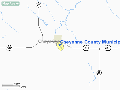
Cheyenne County Municipal Airport (ICAO: KSYF, FAA LID: SYF) is a public airport located one mile (2 km) south of the central business district of St. Francis, a city in Cheyenne County, Kansas, United States. This airport is publicly owned by City of St. Francis.
Although most U.S. airports use the same three-letter location identifier for the FAA and IATA, Cheyenne County Municipal Airport is assigned SYF by the FAA but has no designation from the IATA (which assigned SYF to Silva Bay on Gabriola Island in British Columbia, Canada). The airport's ICAO identifier is KSYF.
Facilities and aircraft
Cheyenne County Municipal Airport covers an area of 307 acres (124 ha) which contains four runways:
- Runway 9/27: 1,799 x 280 ft (548 x 85 m), Surface: Turf
- Runway 13L/31R: 2,833 x 180 ft (863 x 55 m), Surface: Turf
- Runway 13R/31L: 3,138 x 50 ft (956 x 15 m), Surface: Asphalt
- Runway 18/36: 2,313 x 280 ft (705 x 85 m), Surface: Turf
For 12-month period ending June 7, 2006, the airport had 3,950 aircraft operations, an average of 10 per day: 96% general aviation and air taxi. There are 12 aircraft based at this airport, all single engine.
The above content comes from Wikipedia and is published under free licenses – click here to read more.
|
Location &
QuickFacts
|
FAA
Information Effective: |
2008-06-05 |
|
Airport
Identifier: |
SYF |
|
Airport
Status: |
Operational |
|
Longitude/Latitude: |
101-47-45.3000W/39-45-39.8000N
-101.795917/39.761056 (Estimated) |
|
Elevation: |
3411 ft / 1039.67 m (Estimated) |
|
Land: |
307 acres |
|
From
nearest city: |
1 nautical miles S of St Francis, KS |
|
Location: |
Cheyenne County, KS |
|
Magnetic Variation: |
10E (1985) |
Owner & Manager
|
Ownership: |
Publicly owned |
|
Owner: |
City Of St. Francis |
|
Address: |
St. Francis, KS 67756 |
|
Phone
number: |
785-332-2251 |
|
Manager: |
Grace Flying Service |
|
Address: |
Po Box 827
St. Francis, KS 67756 |
|
Phone number: |
785-332-2251 |
Airport Operations and Facilities
|
Airport
Use: |
Open to public |
|
Wind
indicator: |
Yes |
|
Segmented Circle: |
No |
|
Control
Tower: |
No |
|
Lighting
Schedule: |
DUSK-DAWN
ACTVT LIRL RY 14R/32L - CTAF. |
|
Beacon
Color: |
Clear (unlighted land airport) |
|
Landing
fee charge: |
No |
|
Sectional chart: |
Wichita |
|
Region: |
ACE - Central |
|
Boundary
ARTCC: |
ZDV - Denver |
|
Tie-in
FSS: |
ICT - Wichita |
|
FSS on
Airport: |
No |
|
FSS Toll
Free: |
1-800-WX-BRIEF |
|
NOTAMs
Facility: |
ICT (NOTAM-d service avaliable) |
|
Federal Agreements: |
N |
Airport Communications
|
CTAF: |
122.800 |
|
Unicom: |
122.800 |
Airport Services
|
Fuel
available: |
100LL |
|
Airframe
Repair: |
NONE |
|
Power
Plant Repair: |
NONE |
|
Bottled
Oxygen: |
NONE |
|
Bulk
Oxygen: |
NONE |
|
Runway Information
Runway 09/27
|
Dimension: |
1799 x 280 ft / 548.3 x 85.3 m |
|
Surface: |
TURF, Good Condition |
|
|
Runway 09
|
Runway 27
|
|
Longitude: |
101-47-56.2146W |
101-47-33.3877W |
|
Latitude: |
39-45-46.8122N |
39-45-44.4347N |
|
Elevation: |
3392.00 ft |
3386.00 ft |
|
Alignment: |
98 |
127 |
|
Traffic
Pattern: |
Left |
Left |
|
Obstruction: |
, 50:1 slope to clear |
2 ft fence, 20.0 ft from runway, 10:1 slope to clear |
|
Runway 14L/32R
|
Dimension: |
2833 x 180 ft / 863.5 x 54.9 m |
|
Surface: |
TURF, Good Condition |
|
|
Runway 14L
|
Runway 32R
|
|
Longitude: |
101-47-57.3854W |
101-47-36.5731W |
|
Latitude: |
39-45-48.1318N |
39-45-25.2012N |
|
Elevation: |
3392.00 ft |
3409.00 ft |
|
Alignment: |
127 |
127 |
|
Traffic
Pattern: |
Left |
Left |
|
Obstruction: |
40 ft trees, 1075.0 ft from runway, 6 ft right of
centerline, 26:1 slope to clear |
, 50:1 slope to clear |
|
Runway 14R/32L
|
Dimension: |
3138 x 50 ft / 956.5 x 15.2 m |
|
Surface: |
ASPH, Good Condition |
|
Edge Lights: |
Low |
|
|
Runway 14R
|
Runway 32L
|
|
Longitude: |
101-48-01.3015W |
101-47-38.2489W |
|
Latitude: |
39-45-49.6713N |
39-45-24.2802N |
|
Elevation: |
3389.00 ft |
3413.00 ft |
|
Alignment: |
127 |
127 |
|
Traffic
Pattern: |
Left |
Left |
|
Markings: |
Basic, Good Condition |
Basic, Good Condition |
|
Obstruction: |
32 ft trees, 509.0 ft from runway, 2142 ft right of
centerline, 9:1 slope to clear |
, 50:1 slope to clear |
|
Runway 18/36
|
Dimension: |
2313 x 280 ft / 705.0 x 85.3 m |
|
Surface: |
TURF, Good Condition |
|
|
Runway 18
|
Runway 36
|
|
Longitude: |
101-47-32.8118W |
101-47-42.4908W |
|
Latitude: |
39-45-53.6183N |
39-45-32.0172N |
|
Elevation: |
3380.00 ft |
3407.00 ft |
|
Alignment: |
127 |
19 |
|
Traffic
Pattern: |
Left |
Left |
|
Obstruction: |
5 ft fence |
, 50:1 slope to clear |
|
Radio Navigation Aids
|
ID |
Type |
Name |
Ch |
Freq |
Var |
Dist |
|
SYF |
NDB |
St Francis |
|
386.00 |
10E |
2.5 nm |
|
GL |
NDB |
Shugr |
|
414.00 |
09E |
29.5 nm |
|
ADT |
NDB |
Atwood |
|
365.00 |
09E |
35.0 nm |
|
JDM |
NDB |
Wheatfield |
|
408.00 |
08E |
37.7 nm |
|
ITR |
NDB |
Kit Carson |
|
209.00 |
10E |
38.3 nm |
|
IML |
NDB |
Imperial |
|
283.00 |
09E |
45.8 nm |
|
GLD |
VORTAC |
Goodland |
098X |
115.10 |
12E |
22.9 nm |
Remarks
-
PRVDD THE APCH TO
EACH RWY IS MAINTD FOR A MIN 20:1 GLIDE SLOPE AND THE TRSNL SFC BE MAINTD FOR
A 7:1 SLOPE.
Based Aircraft
|
Aircraft based
on field: |
12 |
|
Single Engine
Airplanes: |
12 |
Operational Statistics
Time Period: 2006-07-10 - 2007-07-09
|
Aircraft
Operations: |
76/Week |
|
Air Taxi: |
3.8% |
|
General
Aviation Local: |
75.9% |
|
General
Aviation Itinerant: |
20.3% |
Cheyenne County Municipal Airport
Address:
Cheyenne County, KS
Tel:
785-332-2251
Images
and information placed above are from
http://www.airport-data.com/airport/SYF/
We
thank them for the data!
|
General Info |
| Country |
United
States |
| State |
KANSAS
|
| FAA ID |
SYF
|
| Latitude |
39-45-39.774N |
|
Longitude |
101-47-45.029W |
|
Elevation |
3411
feet |
| Near
City |
ST
FRANCIS |
We don't guarantee the information is fresh and accurate. The data may
be wrong or outdated.
For more up-to-date information please refer to other sources.
|
|


