 |
|
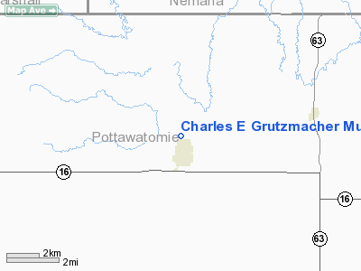
Charles E Grutzmacher Municipal Airport |
|
|
|
Location &
QuickFacts
|
FAA
Information Effective: |
2008-06-05 |
|
Airport
Identifier: |
52K |
|
Airport
Status: |
Operational |
|
Longitude/Latitude: |
096-10-18.0000W/39-29-55.9000N
-96.171667/39.498861 (Estimated) |
|
Elevation: |
1183 ft / 360.58 m (Estimated) |
|
Land: |
36 acres |
|
From
nearest city: |
0 nautical miles W of Onaga, KS |
|
Location: |
Pottawatomie County, KS |
|
Magnetic Variation: |
06E (1985) |
Owner & Manager
|
Ownership: |
Publicly owned |
|
Owner: |
City Of Onaga |
|
Address: |
Po Box 298 - 319 Prospect St.
Onaga, KS 66521 |
|
Phone number: |
785-889-4456 |
|
Manager: |
Gary Holthaus, Mayor |
|
Address: |
Po Box 298
Onaga, KS 66521 |
|
Phone number: |
785-889-4409
HOM PHONE. |
Airport
Operations and Facilities
|
Airport
Use: |
Open to public |
|
Wind
indicator: |
Yes |
|
Segmented Circle: |
No |
|
Control
Tower: |
No |
|
Landing
fee charge: |
No |
|
Sectional chart: |
Kansas City |
|
Region: |
ACE - Central |
|
Boundary
ARTCC: |
ZKC - Kansas City |
|
Tie-in
FSS: |
ICT - Wichita |
|
FSS on
Airport: |
No |
|
FSS Toll
Free: |
1-800-WX-BRIEF |
|
NOTAMs
Facility: |
ICT (NOTAM-d service avaliable) |
Airport Communications
Airport Services
|
Airframe
Repair: |
NONE |
|
Power
Plant Repair: |
NONE |
|
Bottled
Oxygen: |
NONE |
|
Bulk
Oxygen: |
NONE |
|
Runway Information
Runway 18/36
|
Dimension: |
2200 x 61 ft / 670.6 x 18.6 m
WIDTH VARIES FM MIN 61 FT AT AER 36 TO MAX 136 FT AT MIDFLD. |
|
Surface: |
TURF, Fair Condition
SEVERAL HUNDRED FT OF RUNWAY NEAR MIDFIELD IS EXTREMELY ROUGH. |
|
|
Runway 18
|
Runway 36
|
|
Traffic
Pattern: |
Left |
Left |
|
Obstruction: |
64 ft tree, 574.0 ft from runway, 182 ft left of
centerline, 8:1 slope to clear |
32 ft trees, 63.0 ft from runway, 90 ft right of
centerline, 1:1 slope to clear |
|
Radio Navigation Aids
|
ID |
Type |
Name |
Ch |
Freq |
Var |
Dist |
|
MYZ |
NDB |
Marysville |
|
341.00 |
06E |
30.1 nm |
|
MQD |
NDB |
Mc Dowell Creek |
|
391.00 |
06E |
31.3 nm |
|
TO |
NDB |
Biloy |
|
521.00 |
05E |
32.0 nm |
|
CVY |
NDB |
Cavalry |
|
314.00 |
06E |
40.6 nm |
|
DBX |
NDB |
Morrison |
|
212.00 |
06E |
43.3 nm |
|
FNB |
NDB |
Brenner |
|
404.00 |
05E |
44.0 nm |
|
CYW |
NDB |
Clay Center |
|
362.00 |
07E |
46.5 nm |
|
FOE |
TACAN |
Forbes |
053X |
|
05E |
40.8 nm |
|
FRI |
VOR |
Fort Riley |
|
109.40 |
06E |
45.2 nm |
|
MHK |
VOR/DME |
Manhattan |
039X |
110.20 |
06E |
31.4 nm |
|
RBA |
VOR/DME |
Robinson |
019X |
108.20 |
04E |
40.6 nm |
|
TOP |
VORTAC |
Topeka |
125X |
117.80 |
05E |
36.2 nm |
|
PWE |
VORTAC |
Pawnee City |
071X |
112.40 |
05E |
42.2 nm |
|
FOE |
VOT |
Forbes |
|
111.00 |
|
40.4 nm |
Operational Statistics
Time Period: 2005-05-01 - 2006-04-30
|
Aircraft
Operations: |
9/Month |
|
General
Aviation Itinerant: |
100.0% |
Charles E Grutzmacher Municipal Airport
Address:
Pottawatomie County, KS
Tel:
785-889-4456, 785-889-4409
Images
and information placed above are from
http://www.airport-data.com/airport/52K/
We
thank them for the data!
|
General Info |
| Country |
United
States |
| State |
KANSAS
|
| FAA ID |
52K
|
| Latitude |
39-29-49.984N |
|
Longitude |
096-10-30.996W |
|
Elevation |
1183
feet |
| Near
City |
ONAGA
|
We don't guarantee the information is fresh and accurate. The data may
be wrong or outdated.
For more up-to-date information please refer to other sources.
|
|


