 |
|
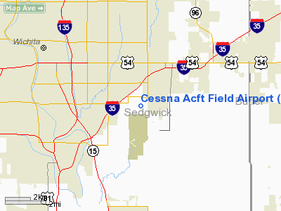
Cessna Aircraft Field Airport |
| Cessna Aircraft Field |
| IATA: CEA â ICAO: KCEA â FAA LID: CEA |
| Summary |
| Airport type |
Public |
| Owner |
Cessna Aircraft Company |
| Serves |
Wichita, Kansas |
| Elevation AMSL |
1,378 ft / 420 m |
| Coordinates |
37°38â²55â³N 097°15â²02â³W / 37.64861°N 97.25056°W / 37.64861; -97.25056 |
| Runways |
| Direction |
Length |
Surface |
| ft |
m |
| 17/35 |
3,873 |
1,180 |
Asphalt |
| Statistics (2008) |
| Aircraft operations |
100 |
| Based aircraft |
16 |
| Source: Federal Aviation Administration |
Cessna Aircraft Field (IATA: CEA, ICAO: KCEA, FAA LID: CEA) is a public use airport located four nautical miles (7 km) southeast of the central business district of Wichita, in Sedgwick County, Kansas, United States. It is privately owned by the Cessna Aircraft Company.
Facilities and aircraft
Cessna Aircraft Field covers an area of 900 acres (364 ha) at an elevation of 1,378 feet (420 m) above mean sea level. It has one runway designated 17/35 with an asphalt measuring 3,873 by 40 feet (1,180 x 12 m).
For the 12-month period ending May 13, 2008, the airport had 100 general aviation aircraft operations, an average of 8 per month. At that time there were 16 aircraft based at this airport: 94% single-engine and 6% multi-engine.
The above content comes from Wikipedia and is published under free licenses – click here to read more.
|
Location &
QuickFacts
|
FAA
Information Effective: |
2008-06-05 |
|
Airport
Identifier: |
CEA |
|
Airport
Status: |
Operational |
|
Longitude/Latitude: |
097-15-02.1580W/37-38-54.9540N
-97.250599/37.648598 (Estimated) |
|
Elevation: |
1378 ft / 420.01 m (Surveyed) |
|
Land: |
900 acres |
|
From
nearest city: |
4 nautical miles SE of Wichita, KS |
|
Location: |
Sedgwick County, KS |
|
Magnetic Variation: |
08E (1980) |
Owner & Manager
|
Ownership: |
Privately owned |
|
Owner: |
Cessna Aircraft Company |
|
Address: |
7603 East Pawnee
Wichita, KS 67207 |
|
Phone
number: |
316-831-2655 |
|
Manager: |
Wayne Dale |
|
Address: |
Cessna Aircraft Company, 7751 East Pawnee
Wichita, KS 67207 |
|
Phone number: |
316-831-2579 |
Airport Operations and Facilities
|
Airport
Use: |
Open to public |
|
Wind
indicator: |
Yes |
|
Segmented Circle: |
Yes |
|
Control
Tower: |
No |
|
Landing
fee charge: |
No |
|
Sectional chart: |
Wichita |
|
Region: |
ACE - Central |
|
Boundary
ARTCC: |
ZKC - Kansas City |
|
Tie-in
FSS: |
ICT - Wichita |
|
FSS on
Airport: |
No |
|
FSS Toll
Free: |
1-800-WX-BRIEF |
|
NOTAMs
Facility: |
ICT (NOTAM-d service avaliable) |
Airport Communications
Airport Services
|
Airframe
Repair: |
NONE |
|
Power
Plant Repair: |
NONE |
|
Bottled
Oxygen: |
NONE |
|
Bulk
Oxygen: |
NONE |
|
Runway Information
Runway 17/35
|
Dimension: |
3873 x 40 ft / 1180.5 x 12.2 m |
|
Surface: |
ASPH, Good Condition |
|
|
Runway 17
|
Runway 35
|
|
Longitude: |
097-15-02.1120W |
097-15-02.1450W |
|
Latitude: |
37-39-14.0690N |
37-38-35.7790N |
|
Elevation: |
1373.00 ft |
1373.00 ft |
|
Alignment: |
127 |
0 |
|
Traffic
Pattern: |
Left |
Right |
|
Markings: |
Basic, Good Condition |
Basic, Good Condition |
|
Displaced
threshold: |
150.00 ft |
150.00 ft |
|
Obstruction: |
10 ft road, 252.0 ft from runway, 5:1 slope to clear
APCH RATIO 40:1 TO DSPLCD THLD. |
13 ft road, 210.0 ft from runway
APCH RATIO 27:1 TO DSPLCD THLD.
8 FT FENCE 170 FT FM RY END. |
|
Radio Navigation Aids
|
ID |
Type |
Name |
Ch |
Freq |
Var |
Dist |
|
IC |
NDB |
Piche |
|
332.00 |
07E |
10.6 nm |
|
EGT |
NDB |
Wellington |
|
414.00 |
07E |
20.6 nm |
|
EQA |
NDB |
El Dorado |
|
383.00 |
05E |
22.1 nm |
|
EWK |
NDB |
Newton |
|
281.00 |
06E |
25.0 nm |
|
MPR |
NDB |
Mc Pherson |
|
227.00 |
06E |
46.9 nm |
|
IAB |
TACAN |
Mc Connell |
112X |
|
07E |
1.8 nm |
|
HUT |
VOR/DME |
Hutchinson |
115X |
116.80 |
09E |
38.6 nm |
|
ICT |
VORTAC |
Wichita |
085X |
113.80 |
07E |
16.9 nm |
|
ICT |
VOT |
Wichita |
|
114.00 |
|
8.7 nm |
Remarks
-
ACFT OPNS SHOULD
COORDINATE WITH MC CONNELL AFB PRIOR TO ARRIVAL AND DEP - CONTROL TOWER
127.25.
-
RWY 17R/35L USED
ONLY BY CESSNA PERSONNEL; CLOSED TO PUBLIC.
-
EXISTED PRIOR TO 1959.
Based Aircraft
|
Aircraft based
on field: |
16 |
|
Single Engine
Airplanes: |
15 |
|
Multi Engine
Airplanes: |
1 |
Operational Statistics
Time Period: 2005-01-12 - 2006-01-11
|
Aircraft
Operations: |
9/Month |
|
General
Aviation Itinerant: |
100.0% |
Cessna Aircraft Field Airport
Address:
Sedgwick County, KS
Tel:
316-831-2655,
316-831-2579
Images
and information placed above are from
http://www.airport-data.com/airport/CEA/
We
thank them for the data!
|
General Info |
| Country |
United
States |
| State |
KANSAS
|
| FAA ID |
CEA
|
| Latitude |
37-38-54.954N |
|
Longitude |
097-15-02.158W |
|
Elevation |
1378
feet |
| Near
City |
WICHITA
|
We don't guarantee the information is fresh and accurate. The data may
be wrong or outdated.
For more up-to-date information please refer to other sources.
|
|


