 |
|
|
|
|
|
|
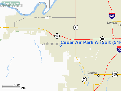
Location &
QuickFacts
|
FAA
Information Effective: |
2008-06-05 |
|
Airport
Identifier: |
51K |
|
Airport
Status: |
Operational |
|
Longitude/Latitude: |
094-53-05.8710W/38-55-53.0200N
-94.884964/38.931394 (Estimated) |
|
Elevation: |
1020 ft / 310.90 m (Estimated) |
|
Land: |
30 acres |
|
From
nearest city: |
4 nautical miles NW of Olathe, KS |
|
Location: |
Johnson County, KS |
|
Magnetic Variation: |
05E (1985) |
Owner & Manager
|
Ownership: |
Privately owned |
|
Owner: |
Hugh Forrest |
|
Address: |
25900 College Blvd.
Olathe, KS 66061 |
|
Phone
number: |
913-782-5176 |
|
Manager: |
Hugh Forrest Wings Unlmtd Inc |
|
Address: |
25900 College Blvd.
Olathe, KS 66061 |
|
Phone number: |
913-782-5176 |
Airport
Operations and Facilities
|
Airport
Use: |
Open to public |
|
Wind
indicator: |
Yes |
|
Segmented Circle: |
No |
|
Control
Tower: |
No |
|
Landing
fee charge: |
No |
|
Sectional chart: |
Kansas City |
|
Region: |
ACE - Central |
|
Boundary
ARTCC: |
ZKC - Kansas City |
|
Tie-in
FSS: |
COU - Columbia |
|
FSS on
Airport: |
No |
|
FSS Toll
Free: |
1-800-WX-BRIEF |
|
NOTAMs
Facility: |
COU (NOTAM-d service avaliable) |
Airport Communications
|
CTAF: |
122.700 |
|
Unicom: |
122.700 |
Airport Services
|
Bottled
Oxygen: |
NONE |
|
Bulk
Oxygen: |
NONE |
|
Runway Information
Runway 17/35
|
Dimension: |
2440 x 75 ft / 743.7 x 22.9 m |
|
Surface: |
TURF, Good Condition |
|
|
Runway 17
|
Runway 35
|
|
Traffic
Pattern: |
Left |
Left |
|
Obstruction: |
32 ft tree, 285.0 ft from runway, 71 ft left of
centerline, 8:1 slope to clear |
18 ft trees, 311.0 ft from runway, 27 ft left of
centerline, 17:1 slope to clear |
|
Radio Navigation Aids
|
ID |
Type |
Name |
Ch |
Freq |
Var |
Dist |
|
GQ |
NDB |
Norge |
|
517.00 |
05E |
13.2 nm |
|
GKB |
NDB |
Norge |
|
517.00 |
05E |
13.2 nm |
|
DO |
NDB |
Dotte |
|
359.00 |
05E |
18.5 nm |
|
LXT |
NDB |
Lesumit |
|
263.00 |
04E |
24.1 nm |
|
GPH |
NDB |
Mosby |
|
284.00 |
03E |
36.7 nm |
|
TO |
NDB |
Biloy |
|
521.00 |
05E |
39.1 nm |
|
FOE |
TACAN |
Forbes |
053X |
|
05E |
36.3 nm |
|
OJC |
VOR/DME |
Johnson County |
077X |
113.00 |
06E |
8.8 nm |
|
RIS |
VOR/DME |
Riverside |
051X |
111.40 |
05E |
17.6 nm |
|
MCI |
VORTAC |
Kansas City |
079Y |
113.25 |
05E |
22.4 nm |
|
TOP |
VORTAC |
Topeka |
125X |
117.80 |
05E |
33.4 nm |
|
ANX |
VORTAC |
Napoleon |
087X |
114.00 |
07E |
36.7 nm |
|
BUM |
VORTAC |
Butler |
106X |
115.90 |
07E |
43.8 nm |
|
MKC |
VOT |
Kansas City Downtown |
|
108.60 |
|
17.7 nm |
|
FOE |
VOT |
Forbes |
|
111.00 |
|
36.6 nm |
Remarks
-
5 FT DROP 30 FT
OFF AER 17.
-
GOLF COURSE N END
OF RY 17 CAN BE MISTAKEN FOR ARPT.
-
WILDLIFE ON & INVOF ARPT.
-
TREES BOTH SIDES
OF RWY.
Based Aircraft
|
Aircraft based
on field: |
5 |
|
Single Engine
Airplanes: |
4 |
|
Gliders: |
1 |
Operational Statistics
Time Period: 2004-09-01 - 2005-08-31
|
Aircraft
Operations: |
64/Week |
|
General
Aviation Local: |
90.9% |
|
General
Aviation Itinerant: |
9.1% |
Cedar Air Park Airport
Address:
Johnson County, KS
Tel:
913-782-5176
Images
and information placed above are from
http://www.airport-data.com/airport/51K/
We
thank them for the data!
|
General Info |
| Country |
United
States |
| State |
KANSAS
|
| FAA ID |
51K
|
| Latitude |
38-55-53.020N |
|
Longitude |
094-53-05.871W |
|
Elevation |
1020
feet |
| Near
City |
OLATHE
|
We don't guarantee the information is fresh and accurate. The data may
be wrong or outdated.
For more up-to-date information please refer to other sources.
|
|


