 |
|
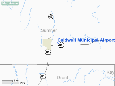
Caldwell Municipal Airport |
|
|
|
Location &
QuickFacts
|
FAA
Information Effective: |
2008-06-05 |
|
Airport
Identifier: |
01K |
|
Airport
Status: |
Operational |
|
Longitude/Latitude: |
097-35-11.1780W/37-02-10.0890N
-97.586438/37.036136 (Estimated) |
|
Elevation: |
1157 ft / 352.65 m (Surveyed) |
|
Land: |
80 acres |
|
From
nearest city: |
1 nautical miles E of Caldwell, KS |
|
Location: |
Sumner County, KS |
|
Magnetic Variation: |
07E (1985) |
Owner & Manager
|
Ownership: |
Publicly owned |
|
Owner: |
City Of Caldwell |
|
Address: |
14 W. Central
Caldwell, KS 67022 |
|
Phone number: |
620-845-6514 |
|
Manager: |
Harold E. Struble |
|
Address: |
104 S Chisholm
Caldwell, KS 67022 |
|
Phone number: |
620-845-2443 |
Airport
Operations and Facilities
|
Airport
Use: |
Open to public |
|
Wind
indicator: |
Yes |
|
Segmented Circle: |
No |
|
Control
Tower: |
No |
|
Lighting
Schedule: |
DUSK-DAWN |
|
Landing
fee charge: |
No
< USERS COMMERCIAL FOR FEE> |
|
Sectional chart: |
Wichita |
|
Region: |
ACE - Central |
|
Boundary
ARTCC: |
ZKC - Kansas City |
|
Tie-in
FSS: |
ICT - Wichita |
|
FSS on
Airport: |
No |
|
FSS Toll
Free: |
1-800-WX-BRIEF |
|
NOTAMs
Facility: |
ICT (NOTAM-d service avaliable) |
Airport Communications
Airport Services
|
Airframe
Repair: |
NONE |
|
Power
Plant Repair: |
NONE |
|
Bottled
Oxygen: |
NONE |
|
Bulk
Oxygen: |
NONE |
|
Runway Information
Runway 17/35
|
Dimension: |
2460 x 110 ft / 749.8 x 33.5 m |
|
Surface: |
TURF, Good Condition |
|
Edge Lights: |
Low |
|
|
Runway 17
|
Runway 35
|
|
Elevation: |
1157.00 ft |
0.00 ft |
|
Traffic
Pattern: |
Left |
Left |
|
Obstruction: |
13 ft road, 40.0 ft from runway, 3:1 slope to clear |
15 ft road, 180.0 ft from runway, 12:1 slope to clear |
|
Radio Navigation Aids
|
ID |
Type |
Name |
Ch |
Freq |
Var |
Dist |
|
EGT |
NDB |
Wellington |
|
414.00 |
07E |
19.7 nm |
|
PN |
NDB |
Ponca |
|
515.00 |
05E |
26.6 nm |
|
IC |
NDB |
Piche |
|
332.00 |
07E |
33.2 nm |
|
IAB |
TACAN |
Mc Connell |
112X |
|
07E |
38.4 nm |
|
ODG |
VOR/DME |
Woodring |
027X |
109.00 |
08E |
41.0 nm |
|
PER |
VORTAC |
Pioneer |
079X |
113.20 |
06E |
26.9 nm |
|
ANY |
VORTAC |
Anthony |
076X |
112.90 |
07E |
29.0 nm |
|
ICT |
VORTAC |
Wichita |
085X |
113.80 |
07E |
42.6 nm |
|
END |
VORTAC |
Vance |
101X |
115.40 |
09E |
44.5 nm |
|
ICT |
VOT |
Wichita |
|
114.00 |
|
36.8 nm |
Remarks
-
COMMERCIAL
SPRAYER BASED AT AIRPORT.
-
RY 17 HAS A 3 FT
DITCH OFF END OF RY.
Based Aircraft
|
Aircraft based
on field: |
4 |
|
Single Engine
Airplanes: |
4 |
Operational Statistics
Time Period: 2006-06-09 - 2007-06-08
|
Aircraft
Operations: |
37/Week |
|
General
Aviation Local: |
78.9% |
|
General
Aviation Itinerant: |
21.1% |
Caldwell Municipal Airport
Address:
Sumner County, KS
Tel:
620-845-6514, 620-845-2443
Images
and information placed above are from
http://www.airport-data.com/airport/01K/
We
thank them for the data!
|
General Info |
| Country |
United
States |
| State |
KANSAS
|
| FAA ID |
01K
|
| Latitude |
37-02-10.089N |
|
Longitude |
097-35-11.178W |
|
Elevation |
1157
feet |
| Near
City |
CALDWELL
|
We don't guarantee the information is fresh and accurate. The data may
be wrong or outdated.
For more up-to-date information please refer to other sources.
|
|


