 |
|
|
Location &
QuickFacts
|
FAA
Information Effective: |
2008-06-05 |
|
Airport
Identifier: |
33KS |
|
Airport
Status: |
Operational |
|
Longitude/Latitude: |
095-36-33.9250W/39-09-10.9960N
-95.609424/39.153054 (Estimated) |
|
Elevation: |
950 ft / 289.56 m (Estimated) |
|
Land: |
30 acres |
|
From
nearest city: |
4 nautical miles N of Topeka, KS |
|
Location: |
Shawnee County, KS |
|
Magnetic Variation: |
06E (1985) |
Owner & Manager
|
Ownership: |
Privately owned |
|
Owner: |
Buena Terra Airpark, Llc |
|
Address: |
5919 Ne Shaffer Rd
Topeka, KS 66617 |
|
Phone
number: |
913-246-0532 |
|
Manager: |
Connie S. Searcy, Secretary |
|
Address: |
5919 Ne Shaffer Rd
Topeka, KS 66617 |
|
Phone number: |
913-246-0532 |
Airport Operations and Facilities
|
Airport
Use: |
Private |
|
Wind
indicator: |
Yes |
|
Segmented Circle: |
No |
|
Control
Tower: |
No |
|
Landing
fee charge: |
No |
|
Sectional chart: |
Kansas City |
|
Region: |
ACE - Central |
|
Boundary
ARTCC: |
ZKC - Kansas City |
|
Tie-in
FSS: |
ICT - Wichita |
|
FSS on
Airport: |
No |
|
FSS Toll
Free: |
1-800-WX-BRIEF |
|
Runway Information
Runway 01/19
|
Dimension: |
2500 x 80 ft / 762.0 x 24.4 m |
|
Surface: |
TURF, |
|
|
Runway 01
|
Runway 19
|
|
Traffic
Pattern: |
Left |
Left |
|
Runway 17/35
|
Dimension: |
2000 x 80 ft / 609.6 x 24.4 m |
|
Surface: |
TURF, |
|
|
Runway 17
|
Runway 35
|
|
Traffic
Pattern: |
Left |
Left |
|
Radio Navigation Aids
|
ID |
Type |
Name |
Ch |
Freq |
Var |
Dist |
|
TO |
NDB |
Biloy |
|
521.00 |
05E |
4.1 nm |
|
DO |
NDB |
Dotte |
|
359.00 |
05E |
40.3 nm |
|
GQ |
NDB |
Norge |
|
517.00 |
05E |
44.8 nm |
|
GKB |
NDB |
Norge |
|
517.00 |
05E |
44.8 nm |
|
MQD |
NDB |
Mc Dowell Creek |
|
391.00 |
06E |
47.6 nm |
|
FOE |
TACAN |
Forbes |
053X |
|
05E |
12.6 nm |
|
RBA |
VOR/DME |
Robinson |
019X |
108.20 |
04E |
42.8 nm |
|
OJC |
VOR/DME |
Johnson County |
077X |
113.00 |
06E |
44.9 nm |
|
RIS |
VOR/DME |
Riverside |
051X |
111.40 |
05E |
47.3 nm |
|
MHK |
VOR/DME |
Manhattan |
039X |
110.20 |
06E |
49.4 nm |
|
TOP |
VORTAC |
Topeka |
125X |
117.80 |
05E |
3.0 nm |
|
MCI |
VORTAC |
Kansas City |
079Y |
113.25 |
05E |
41.4 nm |
|
FOE |
VOT |
Forbes |
|
111.00 |
|
12.4 nm |
|
MKC |
VOT |
Kansas City Downtown |
|
108.60 |
|
47.2 nm |
Remarks
-
PROVIDED
APPROACHES ARE MAINTAINED FOR A 20:1 GLIDE SLOPE AND TRANSITIONAL SURFACES
MAINTAINED FOR A 7:1 SLOPE.
Based Aircraft
|
Aircraft based
on field: |
4 |
|
Single Engine
Airplanes: |
4 |
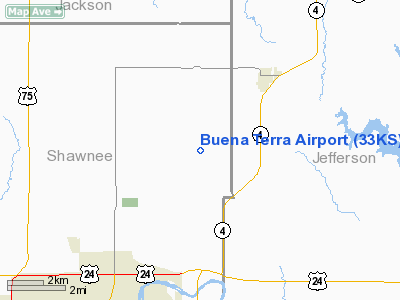
Buena Terra Airport
Address:
Shawnee County, KS
Tel:
913-246-0532
Images
and information placed above are from
http://www.airport-data.com/airport/33KS/
We
thank them for the data!
|
General Info |
| Country |
United
States |
| State |
KANSAS
|
| FAA ID |
33KS
|
| Latitude |
39-09-10.996N |
|
Longitude |
095-36-33.925W |
|
Elevation |
950 feet
|
| Near
City |
TOPEKA
|
We don't guarantee the information is fresh and accurate. The data may
be wrong or outdated.
For more up-to-date information please refer to other sources.
|
|


