 |
|
|
Location &
QuickFacts
|
FAA
Information Effective: |
2008-06-05 |
|
Airport
Identifier: |
SN44 |
|
Airport
Status: |
Operational |
|
Longitude/Latitude: |
095-54-00.9430W/37-18-00.2150N
-95.900262/37.300060 (Estimated) |
|
Elevation: |
850 ft / 259.08 m (Estimated) |
|
Land: |
0 acres |
|
From
nearest city: |
1 nautical miles NE of Elk City, KS |
|
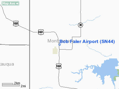
Location: |
Montgomery County, KS |
|
Magnetic Variation: |
06E (1985) |
Owner & Manager
|
Ownership: |
Privately owned |
|
Owner: |
Robert D Faler |
|
Address: |
Route 1
Elk City, KS 67344 |
|
Phone number: |
316-627-2510 |
|
Manager: |
Robert D. Faler |
|
Address: |
Rt 1
Elk City, KS 67344 |
|
Phone number: |
316-627-2510 |
Airport Operations and Facilities
|
Airport Use: |
Private |
|
Wind indicator: |
Yes |
|
Segmented Circle: |
No |
|
Control Tower: |
No |
|
Landing fee charge: |
No |
|
Sectional chart: |
Kansas City |
|
Region: |
ACE - Central |
|
Boundary ARTCC: |
ZKC - Kansas City |
|
Tie-in FSS: |
ICT - Wichita |
|
FSS on Airport: |
No |
|
FSS Toll Free: |
1-800-WX-BRIEF |
Airport Services
|
Fuel
available: |
100 |
|
Airframe
Repair: |
NONE |
|
Power
Plant Repair: |
NONE |
|
Runway
Information
Runway N/S
|
Dimension: |
3150 x 100 ft / 960.1 x 30.5 m |
|
Surface: |
TURF, |
|
|
Runway N
|
Runway S
|
|
Traffic
Pattern: |
Left |
Left |
|
Radio Navigation Aids
|
ID |
Type |
Name |
Ch |
Freq |
Var |
Dist |
|
PPF |
NDB |
Parsons |
|
258.00 |
06E |
18.9 nm |
|
CFV |
NDB |
Coffeyville |
|
212.00 |
05E |
20.1 nm |
|
MSB |
NDB |
Monarch |
|
410.00 |
04E |
37.5 nm |
|
CNU |
VOR/DME |
Chanute |
029X |
109.20 |
05E |
24.5 nm |
|
BVO |
VOR/DME |
Bartlesville |
126X |
117.90 |
08E |
28.6 nm |
|
OSW |
VORTAC |
Oswego |
123X |
117.60 |
08E |
34.4 nm |
Remarks
-
INVOLVES PERSONAL
RISK ON TAKEOFFS & LANDINGS DUE TO THE PLINE LOCATED NEAR MID-FIELD.
Based Aircraft
|
Aircraft based
on field: |
3 |
|
Single Engine
Airplanes: |
3 |
Bob Faler Airport
Address:
Montgomery County, KS
Tel:
316-627-2510
Images
and information placed above are from
http://www.airport-data.com/airport/SN44/
We
thank them for the data!
|
General Info |
| Country |
United
States |
| State |
KANSAS
|
| FAA ID |
SN44
|
| Latitude |
37-18-00.215N |
|
Longitude |
095-54-00.943W |
|
Elevation |
850 feet
|
| Near
City |
ELK CITY
|
We don't guarantee the information is fresh and accurate. The data may
be wrong or outdated.
For more up-to-date information please refer to other sources.
|
|


