 |
|
Blosser Municipal Airport |
Coordinates: 39°32â²57â³N 097°39â²08â³W / 39.54917°N 97.65222°W / 39.54917; -97.65222
| Blosser Municipal Airport |
| IATA: CNK â ICAO: KCNK â FAA LID: CNK |
| Summary |
| Airport type |
Public |
| Owner |
City of Concordia |
| Serves |
Concordia, Kansas |
| Elevation AMSL |
1,486 ft / 453 m |
| Runways |
| Direction |
Length |
Surface |
| ft |
m |
| 17/35 |
3,600 |
1,097 |
Asphalt |
| 12/30 |
2,205 |
672 |
Turf |
| 3/21 |
1,665 |
507 |
Turf |
| Statistics (2007) |
| Aircraft operations |
14,550 |
| Based aircraft |
9 |
| Source: Federal Aviation Administration |
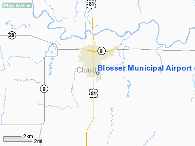
Blosser Municipal Airport (IATA: CNK, ICAO: KCNK, FAA LID: CNK) is a city-owned public-use airport located two miles (3 km) south of the central business district of Concordia, in Cloud County, Kansas, United States. The airport was named after Charles H. Blosser, a longtime Concordia resident, aviation enthusiast, and former city mayor. It is located on land originally owned by the Blosser family.
Facilities and aircraft
Blosser Municipal Airport covers an area of 209 acres (85 ha) which contains one asphalt paved runways (17/35) measuring 3,600 x 60 ft (1,097 x 18 m). It also has two turf runways: 12/30 measuring 2,205 x 265 ft (672 x 81 m) and 3/21 at 1,665 x 255 ft (507 x 78 m).
For the 12-month period ending July 24, 2007, the airport had 14,550 aircraft operations, an average of 39 per day: 97% general aviation and 3% military. At that time there were 9 aircraft based at this airport: 89% single-engine and 11% ultralight.
The above content comes from Wikipedia and is published under free licenses – click here to read more.
|
Location &
QuickFacts
|
FAA
Information Effective: |
2008-06-05 |
|
Airport
Identifier: |
CNK |
|
Airport
Status: |
Operational |
|
Longitude/Latitude: |
097-39-08.3400W/39-32-57.3050N
-97.652317/39.549251 (Estimated) |
|
Elevation: |
1486 ft / 452.93 m (Surveyed) |
|
Land: |
209 acres |
|
From
nearest city: |
2 nautical miles S of Concordia, KS |
|
Location: |
Cloud County, KS |
|
Magnetic Variation: |
07E (1990) |
Owner & Manager
|
Ownership: |
Publicly owned |
|
Owner: |
City Of Concordia |
|
Address: |
Box 603 (city Office)
Concordia, KS 66901 |
|
Manager: |
Ron Copple |
|
Address: |
701 Washington
Concordia, KS 66901 |
|
Phone number: |
785-243-2670 |
Airport
Operations and Facilities
|
Airport
Use: |
Open to public |
|
Wind
indicator: |
Yes |
|
Segmented Circle: |
Yes |
|
Control
Tower: |
No |
|
Lighting
Schedule: |
DUSK-DAWN
MIRL RY 17/35 PRESET MED INTST DUSK-2200; AFT 2200 ACTVT - CTAF. |
|
Beacon
Color: |
Clear-Green (lighted land airport) |
|
Landing
fee charge: |
No |
|
Sectional chart: |
Wichita |
|
Region: |
ACE - Central |
|
Boundary
ARTCC: |
ZKC - Kansas City |
|
Tie-in
FSS: |
ICT - Wichita |
|
FSS on
Airport: |
No |
|
FSS Toll
Free: |
1-800-WX-BRIEF |
|
NOTAMs
Facility: |
CNK (NOTAM-d service avaliable) |
|
Federal Agreements: |
NGY |
Airport Communications
|
CTAF: |
122.800 |
|
Unicom: |
122.800 |
Airport Services
|
Fuel
available: |
100LLMOGAS
FUEL AVBL 24 HRS BY CREDIT CARD. |
|
Bottled
Oxygen: |
NONE |
|
Bulk
Oxygen: |
NONE |
|
Runway Information
Runway 03/21
|
Dimension: |
1665 x 255 ft / 507.5 x 77.7 m |
|
Surface: |
TURF, Good Condition |
|
|
Runway 03
|
Runway 21
|
|
Longitude: |
097-39-08.0780W |
097-38-55.3200W |
|
Latitude: |
39-32-46.9260N |
39-32-59.6290N |
|
Elevation: |
1473.00 ft |
1451.00 ft |
|
Alignment: |
38 |
127 |
|
Traffic
Pattern: |
Left |
Left |
|
Markings: |
Nonstandard,
RY 03/21 DELINEATED WITH RED & WHITE STRIPED MKRS. |
Nonstandard,
RWY END AND EDGES DELINEATED WITH RED AND WHITE STRIPED MKRS. |
|
Obstruction: |
80 ft tree, 1332.0 ft from runway, 16:1 slope to clear |
43 ft trees, 288.0 ft from runway, 30 ft left of
centerline, 6:1 slope to clear |
|
Runway 12/30
|
Dimension: |
2205 x 265 ft / 672.1 x 80.8 m |
|
Surface: |
TURF, Good Condition |
|
|
Runway 12
|
Runway 30
|
|
Longitude: |
097-39-18.4580W |
097-38-57.1100W |
|
Latitude: |
39-33-08.7660N |
39-32-53.6990N |
|
Elevation: |
1473.00 ft |
1455.00 ft |
|
Alignment: |
127 |
127 |
|
Traffic
Pattern: |
Left |
Left |
|
Markings: |
Nonstandard,
DELINEATED WITH RED & WHITE STRIPED MKRS. |
Nonstandard,
RWY DELINEATED WITH RED & WHITE STRIPED MKRS. |
|
Runway 17/35
|
Dimension: |
3600 x 60 ft / 1097.3 x 18.3 m |
|
Surface: |
ASPH, |
|
Weight Limit: |
Single wheel: 8000 lbs.
Dual wheel: 10000 lbs.
OBTAINED EARLIER FM DESIGN CRITERIA DURING NEW CONSTRUCTION.
OBTAINED EARLIER FM DESIGN CRITERIA DURING NEW CONSTRUCTION. |
|
Edge Lights: |
Medium |
|
|
Runway 17
|
Runway 35
|
|
Longitude: |
097-39-11.7860W |
097-39-11.4980W |
|
Latitude: |
39-33-14.5160N |
39-32-38.9340N |
|
Elevation: |
1472.00 ft |
1486.00 ft |
|
Alignment: |
127 |
127 |
|
Traffic
Pattern: |
Left |
Left |
|
Markings: |
Non-precision instrument, Good Condition |
Non-precision instrument, Good Condition |
|
Obstruction: |
, 50:1 slope to clear |
160 ft tree, 2007.0 ft from runway, 11:1 slope to clear |
|
Radio Navigation Aids
|
ID |
Type |
Name |
Ch |
Freq |
Var |
Dist |
|
CNK |
NDB |
Concordia |
|
335.00 |
06E |
0.3 nm |
|
RPB |
NDB |
Republican |
|
414.00 |
07E |
15.9 nm |
|
CYW |
NDB |
Clay Center |
|
362.00 |
07E |
24.9 nm |
|
DBX |
NDB |
Morrison |
|
212.00 |
06E |
31.0 nm |
|
HJH |
NDB |
Hebron |
|
323.00 |
06E |
36.3 nm |
|
FBY |
NDB |
Fairbury |
|
293.00 |
06E |
43.9 nm |
|
TKO |
VORTAC |
Mankato |
035X |
109.80 |
10E |
32.1 nm |
|
SLN |
VORTAC |
Salina |
118X |
117.10 |
07E |
37.5 nm |
Remarks
-
<
& WKENDS EVENINGS, 400? TO ARPT OF E FLYING AIRPLANE MODEL CTLD>
-
PHONE AVBL 24 HRS.
Based Aircraft
|
Aircraft based
on field: |
9 |
|
Single Engine
Airplanes: |
8 |
|
Ultralights: |
1 |
Operational Statistics
Time Period: 2006-07-25 - 2007-07-24
|
Aircraft
Operations: |
280/Week |
|
General
Aviation Local: |
55.0% |
|
General
Aviation Itinerant: |
42.3% |
|
Military: |
2.7% |
Blosser Municipal Airport
Address:
Cloud County, KS
Tel:
785-243-2670
Images
and information placed above are from
http://www.airport-data.com/airport/CNK/
We
thank them for the data!
|
General Info |
| Country |
United
States |
| State |
KANSAS
|
| FAA ID |
CNK
|
| Latitude |
39-32-57.305N |
|
Longitude |
097-39-08.340W |
|
Elevation |
1486
feet |
| Near
City |
CONCORDIA |
We don't guarantee the information is fresh and accurate. The data may
be wrong or outdated.
For more up-to-date information please refer to other sources.
|
|


