|
|
Augusta Municipal Airport |
Coordinates: 37°40â²17â³N 097°04â²40â³W / 37.67139°N 97.07778°W / 37.67139; -97.07778
| Augusta Municipal Airport |
| IATA: none â ICAO: none â FAA LID: 3AU |
| Summary |
| Airport type |
Public |
| Owner |
City of Augusta |
| Serves |
Augusta, Kansas |
| Elevation AMSL |
1,328 ft / 405 m |
| Runways |
| Direction |
Length |
Surface |
| ft |
m |
| 18/36 |
4,199 |
1280 |
Asphalt |
| Statistics (2008) |
| Aircraft operations |
36,000 |
| Based aircraft |
65 |
| Source: Federal Aviation Administration |
Augusta Municipal Airport (FAA LID: 3AU) is a city-owned public-use airport located five miles (8 km) west of the central business district of Augusta, a city in Butler County, Kansas, United States.
Facilities and aircraft
Augusta Municipal Airport covers an area of 140 acres (57 ha) which contains one runway: 18/36 with a 4,199 x 60 ft (1,280 x 18 m) asphalt pavement.
For the 12-month period ending June 03, 2008, the airport had 36,000 general aviation aircraft operations, an average of 99 per day. At that time there were 65 aircraft based at this airport: 85% single-engine and 15% multi-engine.
The above content comes from Wikipedia and is published under free licenses – click here to read more.
|
 |
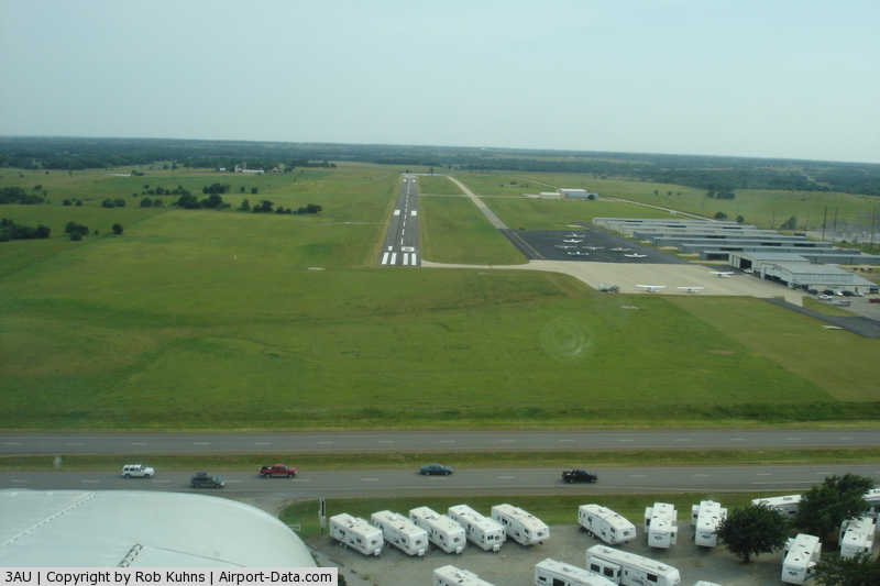
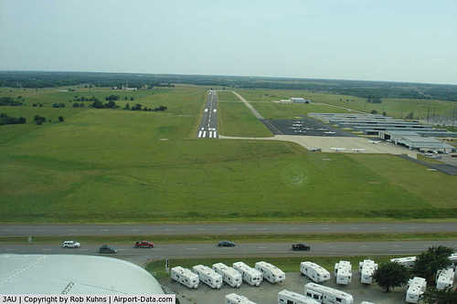
(Click on the photo to enlarge) |
|
 |
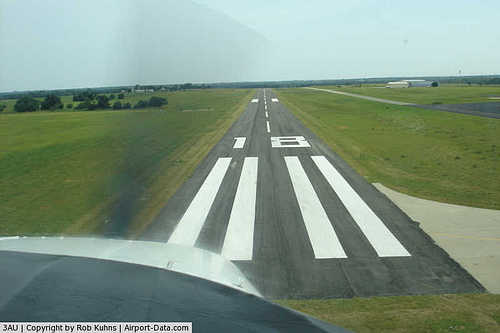
(Click on the photo to enlarge) |
|
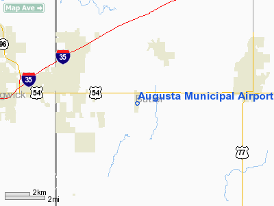
Location &
QuickFacts
|
FAA
Information Effective: |
2008-06-05 |
|
Airport
Identifier: |
3AU |
|
Airport
Status: |
Operational |
|
Longitude/Latitude: |
097-04-40.3400W/37-40-17.8600N
-97.077872/37.671628 (Estimated) |
|
Elevation: |
1328 ft / 404.77 m (Surveyed) |
|
Land: |
140 acres |
|
From
nearest city: |
5 nautical miles W of Augusta, KS |
|
Location: |
Butler County, KS |
|
Magnetic Variation: |
08E (1975) |
Owner & Manager
|
Ownership: |
Publicly owned |
|
Owner: |
City Of Augusta |
|
Address: |
6th & School Box 486
Augusta, KS 67010 |
|
Phone
number: |
316-775-4510 |
|
Manager: |
J. Tyler Setchell |
|
Address: |
4800 W Beech Suite 1
Augusta, KS 67010 |
|
Phone number: |
316-733-1326 |
Airport Operations and Facilities
|
Airport
Use: |
Open to public |
|
Wind
indicator: |
Yes |
|
Segmented Circle: |
Yes |
|
Control
Tower: |
No |
|
Lighting
Schedule: |
DUSK-DAWN
ACTVT MIRL RY 18/36; REIL RYS 18 & 36; VASI RY 36; PAPI RY 18 &
PERIMETER LGTS ON H1 - CTAF. |
|
Beacon
Color: |
Clear-Green (lighted land airport) |
|
Landing
fee charge: |
No |
|
Sectional chart: |
Wichita |
|
Region: |
ACE - Central |
|
Boundary
ARTCC: |
ZKC - Kansas City |
|
Tie-in
FSS: |
ICT - Wichita |
|
FSS on
Airport: |
No |
|
FSS Toll
Free: |
1-800-WX-BRIEF |
|
NOTAMs
Facility: |
ICT (NOTAM-d service avaliable) |
|
Federal Agreements: |
NGY |
Airport Communications
|
CTAF: |
122.800 |
|
Unicom: |
122.800 |
Airport Services
|
Fuel
available: |
100LLA |
|
Airframe
Repair: |
MAJOR |
|
Power
Plant Repair: |
MAJOR |
|
Bottled
Oxygen: |
LOW |
|
Bulk
Oxygen: |
NONE |
|
Runway Information
Runway 18/36
|
Dimension: |
4199 x 60 ft / 1279.9 x 18.3 m |
|
Surface: |
ASPH, Good Condition |
|
Weight Limit: |
Single wheel: 12000 lbs. |
|
Edge Lights: |
Medium |
|
|
Runway 18
|
Runway 36
|
|
Longitude: |
097-04-38.4040W |
097-04-42.2090W |
|
Latitude: |
37-40-38.5780N |
37-39-57.1740N |
|
Elevation: |
1327.00 ft |
1304.00 ft |
|
Alignment: |
127 |
4 |
|
Traffic
Pattern: |
Left |
Right |
|
Markings: |
Non-precision instrument, Good Condition |
Non-precision instrument, Good Condition |
|
Crossing
Height: |
0.00 ft |
43.00 ft |
|
VASI: |
4-light PAPI on left side |
2-box on left side |
|
Visual
Glide Angle: |
0.00° |
3.00° |
|
Runway End
Identifier: |
Yes |
Yes |
|
Obstruction: |
31 ft bldg, 1100.0 ft from runway, 29:1 slope to clear |
, 50:1 slope to clear |
|
Helipad H1
|
Dimension: |
30 x 30 ft / 9.1 x 9.1 m |
|
Surface: |
CONC, Good Condition |
|
|
Runway H1
|
Runway
|
|
Traffic
Pattern: |
Left |
Left |
|
Radio Navigation Aids
|
ID |
Type |
Name |
Ch |
Freq |
Var |
Dist |
|
EQA |
NDB |
El Dorado |
|
383.00 |
05E |
14.0 nm |
|
IC |
NDB |
Piche |
|
332.00 |
07E |
18.8 nm |
|
EWK |
NDB |
Newton |
|
281.00 |
06E |
25.4 nm |
|
EGT |
NDB |
Wellington |
|
414.00 |
07E |
25.7 nm |
|
MPR |
NDB |
Mc Pherson |
|
227.00 |
06E |
49.9 nm |
|
IAB |
TACAN |
Mc Connell |
112X |
|
07E |
9.5 nm |
|
HUT |
VOR/DME |
Hutchinson |
115X |
116.80 |
09E |
45.1 nm |
|
ICT |
VORTAC |
Wichita |
085X |
113.80 |
07E |
24.5 nm |
|
ICT |
VOT |
Wichita |
|
114.00 |
|
17.1 nm |
Remarks
-
FOR SVC AFT HRS
CALL (316)-733-1326.
-
HELIPAD H1 CLOSED INDEFLY.
Based Aircraft
|
Aircraft based
on field: |
94 |
|
Single Engine
Airplanes: |
82 |
|
Multi Engine
Airplanes: |
6 |
|
Jet Engine
Airplanes: |
1 |
|
Helicopters: |
5 |
Operational Statistics
Time Period: 2006-07-25 - 2007-07-24
|
Aircraft
Operations: |
99/Day |
|
General
Aviation Local: |
58.3% |
|
General
Aviation Itinerant: |
41.7% |
Augusta Municipal Airport
Address:
Butler County, KS
Tel:
316-775-4510,
316-733-1326
Images
and information placed above are from
http://www.airport-data.com/airport/3AU/
We
thank them for the data!
|
General Info |
| Country |
United
States |
| State |
KANSAS
|
| FAA ID |
3AU
|
| Latitude |
37-40-17.860N |
|
Longitude |
097-04-40.340W |
|
Elevation |
1328
feet |
| Near
City |
AUGUSTA
|
We don't guarantee the information is fresh and accurate. The data may
be wrong or outdated.
For more up-to-date information please refer to other sources.
|
|