 |
|
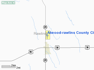
Atwood-rawlins County City-county Airport |
Atwood-Rawlins County
City-County Airport |
| IATA: none â ICAO: KADT â FAA LID: ADT |
| Summary |
| Airport type |
Public |
| Owner |
City of Atwood & Rawlins County |
| Serves |
Rawlins County |
| Location |
Atwood, Kansas |
| Elevation AMSL |
2,991 ft / 912 m |
| Coordinates |
39°50â²24â³N 101°02â²31â³W / 39.84°N 101.04194°W / 39.84; -101.04194 |
| Runways |
| Direction |
Length |
Surface |
| ft |
m |
| 16/34 |
5,000 |
1,524 |
Asphalt |
| 17/35 |
2,420 |
738 |
Turf |
| 3/21 |
2,400 |
732 |
Turf |
| Statistics (2006) |
| Aircraft operations |
12,300 |
| Source: Federal Aviation Administration |
Atwood-Rawlins County City-County Airport (ICAO: KADT, FAA LID: ADT) is a public airport located two miles (3 km) north of the central business district of Atwood, in Rawlins County, Kansas, United States. It is owned by the City of Atwood & Rawlins County.
Although most U.S. airports use the same three-letter location identifier for the FAA and IATA, Atwood-Rawlins County City-County Airport is assigned ADT by the FAA but has no designation from the IATA.
Facilities and aircraft
Atwood-Rawlins County City-County Airport covers an area of 250 acres (101 ha) which contains three runways: one is asphalt paved (runway 16/34 measuring 5,001 x 75 ft) and two have a turf surface (17/35 at 2,420 x 75 ft (23 m) and 3/21 at 2,400 x 100 ft). For the 12-month period ending June 9, 2006, the airport had 12,300 aircraft operations, an average of 33 per day: 98% general aviation and 2% air taxi.
The above content comes from Wikipedia and is published under free licenses – click here to read more.
|
Location &
QuickFacts
|
FAA
Information Effective: |
2008-06-05 |
|
Airport
Identifier: |
ADT |
|
Airport
Status: |
Operational |
|
Longitude/Latitude: |
101-02-31.3000W/39-50-24.5000N
-101.042028/39.840139 (Estimated) |
|
Elevation: |
2991 ft / 911.66 m (Surveyed) |
|
Land: |
250 acres |
|
From
nearest city: |
2 nautical miles N of Atwood, KS |
|
Location: |
Rawlins County, KS |
|
Magnetic Variation: |
09E (1985) |
Owner & Manager
|
Ownership: |
Publicly owned |
|
Owner: |
City Of Atwood & Rawlins Co. |
|
Address: |
Atwood, KS 67730 |
|
Phone
number: |
785-626-3344 |
|
Manager: |
Clarence Niermeir |
|
Address: |
Rr#1 Box 24
Ludell, KS 67744-9517 |
|
Phone number: |
785-626-9014 |
Airport
Operations and Facilities
|
Airport
Use: |
Open to public |
|
Wind
indicator: |
Yes |
|
Segmented Circle: |
No |
|
Control
Tower: |
No |
|
Lighting
Schedule: |
DUSK-DAWN |
|
Beacon
Color: |
Clear-Green (lighted land airport) |
|
Landing
fee charge: |
No |
|
Sectional chart: |
Wichita |
|
Region: |
ACE - Central |
|
Boundary
ARTCC: |
ZDV - Denver |
|
Tie-in
FSS: |
ICT - Wichita |
|
FSS on
Airport: |
No |
|
FSS Toll
Free: |
1-800-WX-BRIEF |
|
NOTAMs
Facility: |
ICT (NOTAM-d service avaliable) |
|
Federal Agreements: |
NGY |
Airport Communications
|
CTAF: |
122.700 |
|
Unicom: |
122.700 |
Airport Services
|
Fuel
available: |
100LL
24 HR SELF-SERVE FUEL. |
|
Bottled
Oxygen: |
NONE |
|
Bulk
Oxygen: |
NONE |
|
Runway Information
Runway 03/21
|
Dimension: |
2400 x 100 ft / 731.5 x 30.5 m |
|
Surface: |
TURF, Good Condition
ACUTE DIFFERENCE IN SFC ELEV.
AT
INTERSECTION WITH RY 16/34. |
|
|
Runway 03
|
Runway 21
|
|
Traffic
Pattern: |
Left |
Left |
|
Obstruction: |
28 ft pline, 950.0 ft from runway, 33:1 slope to clear |
, 50:1 slope to clear |
|
Runway 16/34
|
Dimension: |
5001 x 75 ft / 1524.3 x 22.9 m |
|
Surface: |
ASPH,
ACUTE DIFFERENCE IN SFC ELEV.
AT
INTERSECTION WITH RY 16/34. |
|
Weight Limit: |
Single wheel: 12500 lbs.
Dual wheel: 12500 lbs. |
|
Edge Lights: |
Medium |
|
|
Runway 16
|
Runway 34
|
|
Longitude: |
101-02-39.5800W |
101-02-31.8600W |
|
Latitude: |
39-50-53.6900N |
39-50-04.6400N |
|
Elevation: |
2991.00 ft |
2926.00 ft |
|
Alignment: |
127 |
127 |
|
Traffic
Pattern: |
Left |
Left |
|
Markings: |
Non-precision instrument, Good Condition |
Non-precision instrument, Good Condition |
|
Obstruction: |
, 50:1 slope to clear |
20 ft tree, 320.0 ft from runway, 205 ft left of
centerline, 6:1 slope to clear |
|
Runway 17/35
|
Dimension: |
2420 x 75 ft / 737.6 x 22.9 m |
|
Surface: |
TURF, Good Condition
ACUTE DIFFERENCE IN SFC ELEV.
AT
INTERSECTION WITH RY 16/34. |
|
|
Runway 17
|
Runway 35
|
|
Traffic
Pattern: |
Left |
Left |
|
Radio Navigation Aids
|
ID |
Type |
Name |
Ch |
Freq |
Var |
Dist |
|
MCK |
FAN MARKER |
Mc Cook |
|
|
11E |
30.7 nm |
|
ADT |
NDB |
Atwood |
|
365.00 |
09E |
0.2 nm |
|
JDM |
NDB |
Wheatfield |
|
408.00 |
08E |
19.8 nm |
|
OIN |
NDB |
Oberlin |
|
341.00 |
09E |
23.3 nm |
|
SYF |
NDB |
St Francis |
|
386.00 |
10E |
34.1 nm |
|
GL |
NDB |
Shugr |
|
414.00 |
09E |
41.8 nm |
|
OEL |
NDB |
Oakley |
|
380.00 |
08E |
45.0 nm |
|
IML |
NDB |
Imperial |
|
283.00 |
09E |
48.5 nm |
|
CSB |
NDB |
Harry Strunk |
|
389.00 |
08E |
49.3 nm |
|
MCK |
VOR/DME |
Mc Cook |
100X |
115.30 |
08E |
30.0 nm |
|
HCT |
VORTAC |
Hayes Center |
124X |
117.70 |
11E |
37.3 nm |
|
GLD |
VORTAC |
Goodland |
098X |
115.10 |
12E |
40.6 nm |
Remarks
-
PUBLIC PHONE AVBL 24 HRS.
-
EXISTED PRIOR TO 1959.
Based Aircraft
|
Aircraft based
on field: |
13 |
|
Single Engine
Airplanes: |
8 |
|
Ultralights: |
5 |
Operational Statistics
Time Period: 2006-07-23 - 2007-07-22
|
Aircraft
Operations: |
237/Week |
|
Air Taxi: |
2.4% |
|
General
Aviation Local: |
65.0% |
|
General
Aviation Itinerant: |
32.5% |
Atwood-rawlins County City-county
Airport
Address:
Rawlins County, KS
Tel:
785-626-3344,
785-626-9014
Images
and information placed above are from
http://www.airport-data.com/airport/ADT/
We
thank them for the data!
|
General Info |
| Country |
United
States |
| State |
KANSAS
|
| FAA ID |
ADT
|
| Latitude |
39-50-24.500N |
|
Longitude |
101-02-31.300W |
|
Elevation |
2991
feet |
| Near
City |
ATWOOD
|
We don't guarantee the information is fresh and accurate. The data may
be wrong or outdated.
For more up-to-date information please refer to other sources.
|
|


