 |
|
Atkinson Municipal Airport |
| Atkinson Municipal Airport |
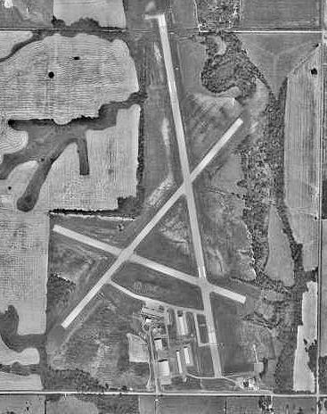 |
| 1991 USGS photo |
| IATA: PTS â ICAO: KPTS â FAA LID: PTS |
| Summary |
| Airport type |
Public |
| Owner |
City of Pittsburg |
| Serves |
Pittsburg, Kansas |
| Elevation AMSL |
950 ft / 290 m |
| Coordinates |
37°26â²58â³N 094°43â²52â³W / 37.44944°N 94.73111°W / 37.44944; -94.73111 |
| Runways |
| Direction |
Length |
Surface |
| ft |
m |
| 16/34 |
5,500 |
1,676 |
Asphalt |
| 4/22 |
4,001 |
1,220 |
Asphalt |
| Statistics (2007) |
| Aircraft operations |
23,600 |
| Based aircraft |
41 |
| Source: Federal Aviation Administration |
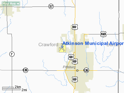
Atkinson Municipal Airport (IATA: PTS, ICAO: KPTS, FAA LID: PTS) is a public use airport located three nautical miles (6 km) northwest of the central business district of Pittsburg, a city in Crawford County, Kansas, United States. It is owned by the City of Pittsburg. Facilities and aircraft
Atkinson Municipal Airport covers an area of 742 acres (300 ha) at an elevation of 950 feet (290 m) above mean sea level. It has two asphalt paved runways: 16/34 measures 5,500 by 100 feet (1,676 x 30 m) and 4/22 is 4,001 by 75 feet (1,220 x 23 m).
For the 12-month period ending September 11, 2007, the airport had 23,600 aircraft operations, an average of 64 per day: 99.6% general aviation and 0.4% military. At that time there were 41 aircraft based at this airport: 68% single-engine, 7% multi-engine, 17% jet, 2% helicopter and 5% ultralight.
History
Established as Pittsburg Airport in April 1940. Taken over by the United States Army Air Force on 25 May 1942 as a basic (level 1) pilot training airfield. Assigned to USAAF Gulf Coast Training Center (later Central Flying Training Command). Conducted contract basic flying training by McFarland Flying Service. Fairchild PT-19s were the primary trainers used. Also had several PT-17 Stearmans and a few P-40 Warhawks assigned. Flight school also operated two auxiliary airfields in the local area. Unpowered glider pilot training was also performed by 21st Army Air Forces Glider Training Detachment from May 1942 until February 1943
Inactivated 20 October 1944 with the drawdown of AAFTC's pilot training program and was declared surplus in 1946. Responsibility for it was given to the War Assets Administration and was eventually acquired by City of Pittsburg.
The above content comes from Wikipedia and is published under free licenses – click here to read more.
|
Location &
QuickFacts
|
FAA
Information Effective: |
2008-06-05 |
|
Airport
Identifier: |
PTS |
|
Airport
Status: |
Operational |
|
Longitude/Latitude: |
094-43-52.0340W/37-26-58.0170N
-94.731121/37.449449 (Estimated) |
|
Elevation: |
950 ft / 289.56 m (Surveyed) |
|
Land: |
742 acres |
|
From
nearest city: |
3 nautical miles NW of Pittsburg, KS |
|
Location: |
Crawford County, KS |
|
Magnetic Variation: |
04E (2000) |
Owner & Manager
|
Ownership: |
Publicly owned |
|
Owner: |
City Of Pittsburg |
|
Address: |
201 W 4th St
Pittsburg, KS 66762 |
|
Phone number: |
620-231-4100 |
|
Manager: |
Gary Iori |
|
Address: |
3510 Arpt Dr
Pittsburg, KS 66762 |
|
Phone number: |
620-231-5760 |
Airport
Operations and Facilities
|
Airport
Use: |
Open to public |
|
Wind
indicator: |
Yes |
|
Segmented Circle: |
No |
|
Control
Tower: |
No |
|
Lighting
Schedule: |
DUSK-DAWN
ACTVT MIRL RYS 04/22 & 16/34; PAPI & REIL RYS 16, 34, 04 & 22 - CTAF. |
|
Beacon
Color: |
Clear-Green (lighted land airport) |
|
Landing
fee charge: |
No |
|
Sectional chart: |
Kansas City |
|
Region: |
ACE - Central |
|
Traffic
Pattern Alt: |
800 ft |
|
Boundary
ARTCC: |
ZKC - Kansas City |
|
Tie-in
FSS: |
ICT - Wichita |
|
FSS on
Airport: |
No |
|
FSS Toll
Free: |
1-800-WX-BRIEF |
|
NOTAMs
Facility: |
ICT (NOTAM-d service avaliable) |
|
Federal Agreements: |
NGY3 |
Airport Communications
|
CTAF: |
123.000 |
|
Unicom: |
123.000 |
Airport Services
|
Fuel
available: |
100LLA |
|
Airframe
Repair: |
MAJOR |
|
Power
Plant Repair: |
MAJOR |
|
Bottled
Oxygen: |
HIGH/LOW |
|
Bulk
Oxygen: |
NONE |
|
Runway Information
Runway 04/22
|
Dimension: |
4001 x 75 ft / 1219.5 x 22.9 m |
|
Surface: |
ASPH, Good Condition |
|
Weight Limit: |
Single wheel: 12500 lbs. |
|
Edge Lights: |
Medium |
|
|
Runway 04
|
Runway 22
|
|
Longitude: |
094-44-10.6420W |
094-43-38.8650W |
|
Latitude: |
37-26-35.1460N |
37-27-05.5170N |
|
Elevation: |
939.00 ft |
919.00 ft |
|
Alignment: |
40 |
127 |
|
Traffic
Pattern: |
Left |
Left |
|
Markings: |
Non-precision instrument, Good Condition |
Non-precision instrument, Good Condition |
|
Crossing
Height: |
40.00 ft |
40.00 ft |
|
VASI: |
4-light PAPI on left side |
4-light PAPI on left side |
|
Visual
Glide Angle: |
3.00° |
3.00° |
|
Runway End
Identifier: |
Yes |
Yes |
|
Obstruction: |
42 ft trees, 1397.0 ft from runway, 28:1 slope to clear |
60 ft trees, 843.0 ft from runway, 119 ft left of
centerline, 10:1 slope to clear |
|
Runway 16/34
|
Dimension: |
5500 x 100 ft / 1676.4 x 30.5 m |
|
Surface: |
ASPH, Good Condition |
|
Weight Limit: |
Single wheel: 30000 lbs.
Dual wheel: 45000 lbs. |
|
Edge Lights: |
Medium |
|
|
Runway 16
|
Runway 34
|
|
Longitude: |
094-43-56.0670W |
094-43-44.0450W |
|
Latitude: |
37-27-30.3680N |
37-26-36.8470N |
|
Elevation: |
932.00 ft |
926.00 ft |
|
Alignment: |
127 |
127 |
|
Traffic
Pattern: |
Left |
Left |
|
Markings: |
Non-precision instrument, Good Condition |
Non-precision instrument, Good Condition |
|
Crossing
Height: |
0.00 ft |
40.00 ft |
|
VASI: |
4-light PAPI on left side |
4-light PAPI on left side |
|
Visual
Glide Angle: |
0.00° |
3.00° |
|
Runway End
Identifier: |
Yes |
Yes |
|
Obstruction: |
50 ft trees, 1853.0 ft from runway, 33:1 slope to clear |
64 ft trees, 2336.0 ft from runway, 33:1 slope to clear |
|
Radio Navigation Aids
|
ID |
Type |
Name |
Ch |
Freq |
Var |
Dist |
|
PTS |
NDB |
Pittsburg |
|
365.00 |
05E |
0.5 nm |
|
LLU |
NDB |
Spring River |
|
356.00 |
05E |
20.2 nm |
|
FSK |
NDB |
Fort Scott |
|
379.00 |
05E |
20.9 nm |
|
EAD |
NDB |
Nevada |
|
209.00 |
06E |
32.0 nm |
|
PPF |
NDB |
Parsons |
|
258.00 |
06E |
37.7 nm |
|
MSB |
NDB |
Monarch |
|
410.00 |
04E |
38.5 nm |
|
CFV |
NDB |
Coffeyville |
|
212.00 |
05E |
45.5 nm |
|
EOS |
VOR/DME |
Neosho |
120X |
117.30 |
07E |
39.1 nm |
|
CNU |
VOR/DME |
Chanute |
029X |
109.20 |
05E |
42.5 nm |
|
OSW |
VORTAC |
Oswego |
123X |
117.60 |
08E |
28.6 nm |
Remarks
-
DEER & BIRDS ON &
INVOF ARPT.
Based Aircraft
|
Aircraft based
on field: |
41 |
|
Single Engine
Airplanes: |
32 |
|
Multi Engine
Airplanes: |
2 |
|
Jet Engine
Airplanes: |
5 |
|
Ultralights: |
2 |
Operational Statistics
Time Period: 2006-09-12 - 2007-09-11
|
Aircraft
Operations: |
65/Day |
|
General
Aviation Local: |
63.6% |
|
General
Aviation Itinerant: |
36.0% |
|
Military: |
0.4% |
Atkinson Municipal Airport
Address:
Crawford County, KS
Tel:
620-231-4100, 620-231-5760
Images
and information placed above are from
http://www.airport-data.com/airport/PTS/
We
thank them for the data!
|
General Info |
| Country |
United
States |
| State |
KANSAS
|
| FAA ID |
PTS
|
| Latitude |
37-26-54.800N |
|
Longitude |
094-43-52.800W |
|
Elevation |
950 feet
|
| Near
City |
PITTSBURG |
We don't guarantee the information is fresh and accurate. The data may
be wrong or outdated.
For more up-to-date information please refer to other sources.
|
|


