 |
|
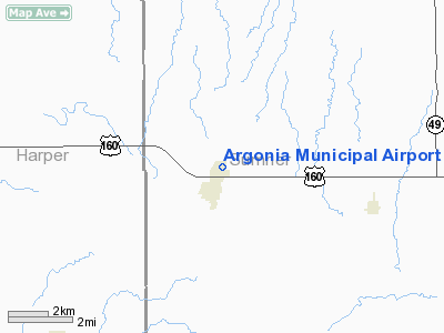
Argonia Municipal Airport |
|
Location &
QuickFacts
|
FAA
Information Effective: |
2008-06-05 |
|
Airport
Identifier: |
2K8 |
|
Airport
Status: |
Operational |
|
Longitude/Latitude: |
097-45-31.5000W/37-16-31.3000N
-97.758750/37.275361 (Estimated) |
|
Elevation: |
1275 ft / 388.62 m (Estimated) |
|
Land: |
80 acres |
|
From
nearest city: |
1 nautical miles NE of Argonia, KS |
|
Location: |
Sumner County, KS |
|
Magnetic Variation: |
07E (1985) |
Owner & Manager
|
Ownership: |
Publicly owned |
|
Owner: |
City Of Argonia |
|
Address: |
210 S. Main
Argonia, KS 67004 |
|
Phone
number: |
620-435-6417 |
|
Manager: |
Robert D. Stephens |
|
Address: |
421 So. Main St
Argonia, KS 67004-9758 |
|
Phone number: |
620-435-6479 |
Airport Operations and Facilities
|
Airport
Use: |
Open to public |
|
Wind
indicator: |
Yes |
|
Segmented Circle: |
No |
|
Control
Tower: |
No |
|
Landing
fee charge: |
No |
|
Sectional chart: |
Wichita |
|
Region: |
ACE - Central |
|
Boundary
ARTCC: |
ZKC - Kansas City |
|
Tie-in
FSS: |
ICT - Wichita |
|
FSS on
Airport: |
No |
|
FSS Toll
Free: |
1-800-WX-BRIEF |
|
NOTAMs
Facility: |
ICT (NOTAM-d service avaliable) |
Airport Communications
|
Runway Information
Runway 17/35
|
Dimension: |
3200 x 60 ft / 975.4 x 18.3 m |
|
Surface: |
TURF, Good Condition |
|
|
Runway 17
|
Runway 35
|
|
Longitude: |
097-45-31.5000W |
097-45-31.5000W |
|
Latitude: |
37-16-47.1400N |
37-16-15.5000N |
|
Traffic
Pattern: |
Left |
Left |
|
Obstruction: |
, 50:1 slope to clear |
22 ft bldg, 170.0 ft from runway, 7:1 slope to clear |
|
Radio Navigation Aids
|
ID |
Type |
Name |
Ch |
Freq |
Var |
Dist |
|
EGT |
NDB |
Wellington |
|
414.00 |
07E |
17.9 nm |
|
IC |
NDB |
Piche |
|
332.00 |
07E |
23.2 nm |
|
PN |
NDB |
Ponca |
|
515.00 |
05E |
41.6 nm |
|
IAB |
TACAN |
Mc Connell |
112X |
|
07E |
31.3 nm |
|
HUT |
VOR/DME |
Hutchinson |
115X |
116.80 |
09E |
44.2 nm |
|
ANY |
VORTAC |
Anthony |
076X |
112.90 |
07E |
20.9 nm |
|
ICT |
VORTAC |
Wichita |
085X |
113.80 |
07E |
29.5 nm |
|
PER |
VORTAC |
Pioneer |
079X |
113.20 |
06E |
42.8 nm |
|
ICT |
VOT |
Wichita |
|
114.00 |
|
26.7 nm |
Remarks
-
PRVDD APCH TO
EACH RWY IS MAINTD FOR A MIN 20:1 GLIDE SLOPE AND THE TRSNL SFC BE MAINTD FOR
A 7:1 SLOPE.
Based Aircraft
|
Aircraft based
on field: |
1 |
|
Single Engine
Airplanes: |
1 |
Operational Statistics
Time Period: 2006-01-19 - 2007-01-18
|
Aircraft
Operations: |
12/Week |
|
General
Aviation Local: |
83.3% |
|
General
Aviation Itinerant: |
16.7% |
Argonia Municipal Airport
Address:
Sumner County, KS
Tel:
620-435-6417,
620-435-6479
Images
and information placed above are from
http://www.airport-data.com/airport/2K8/
We
thank them for the data!
|
General Info |
| Country |
United
States |
| State |
KANSAS
|
| FAA ID |
2K8
|
| Latitude |
37-16-30.074N |
|
Longitude |
097-45-36.191W |
|
Elevation |
1275
feet |
| Near
City |
ARGONIA
|
We don't guarantee the information is fresh and accurate. The data may
be wrong or outdated.
For more up-to-date information please refer to other sources.
|
|


