 |
|
Coordinates: 39°34â²13â³N 095°10â²49â³W / 39.57028°N 95.18028°W / 39.57028; -95.18028
| Amelia Earhart Airport |
| IATA: none â ICAO: none â FAA LID: K59 |
| Summary |
| Airport type |
Public |
| Owner |
City of Atchison |
| Serves |
Atchison, Kansas |
| Elevation AMSL |
1,073 ft / 327 m |
| Runways |
| Direction |
Length |
Surface |
| ft |
m |
| 16/34 |
3,000 |
914 |
Asphalt |
| Statistics (2006) |
| Aircraft operations |
16,100 |
| Based aircraft |
25 |
| Source: Federal Aviation Administration |
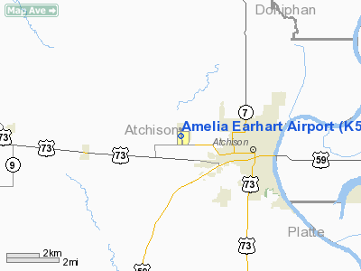
Amelia Earhart Airport (FAA LID: K59) is a city-owned public-use airport located two miles (3 km) west of the central business district of Atchison, a city in Atchison County, Kansas, United States.
Facilities and aircraft
Amelia Earhart Airport covers an area of 77 acres (31 ha) which contains one runway: 16/34 with a 3,000 x 48 ft (914 x 14 m) asphalt pavement.
For the 12-month period ending March 31, 2006, the airport had 16,100 general aviation aircraft operations, an average of 44 per day. At that time there were 25 aircraft based at this airport: 92% single-engine and 8% multi-engine.
The above content comes from Wikipedia and is published under free licenses – click here to read more.
|
Location &
QuickFacts
|
FAA
Information Effective: |
2008-06-05 |
|
Airport
Identifier: |
K59 |
|
Airport
Status: |
Operational |
|
Longitude/Latitude: |
095-10-49.1930W/39-34-13.8890N
-95.180331/39.570525 (Estimated) |
|
Elevation: |
1073 ft / 327.05 m (Surveyed) |
|
Land: |
77 acres |
|
From
nearest city: |
2 nautical miles W of Atchison, KS |
|
Location: |
Atchison County, KS |
|
Magnetic Variation: |
06E (1980) |
Owner & Manager
|
Ownership: |
Publicly owned |
|
Owner: |
City Of Atchison |
|
Address: |
515 Kansas Ave
Atchison, KS 66002 |
|
Phone
number: |
913-367-5560 |
|
Manager: |
Frank Spatz, Fbo
CITY MANAGER KELLY DEMERITT, ALTERNATE ROGER DENTON 913-367-0134 DAYS,
913-367-5566 EVENINGS. |
|
Address: |
16701 286th Rd
Atchison, KS 66002 |
|
Phone number: |
913-367-1872 |
Airport
Operations and Facilities
|
Airport
Use: |
Open to public |
|
Wind
indicator: |
Yes |
|
Segmented Circle: |
Yes |
|
Control
Tower: |
No |
|
Lighting
Schedule: |
DUSK-DAWN
ACTVT LIRL RY 16/34 - CTAF. |
|
Beacon
Color: |
Clear-Green (lighted land airport) |
|
Landing
fee charge: |
No |
|
Sectional chart: |
Kansas City |
|
Region: |
ACE - Central |
|
Boundary
ARTCC: |
ZKC - Kansas City |
|
Tie-in
FSS: |
ICT - Wichita |
|
FSS on
Airport: |
No |
|
FSS Toll
Free: |
1-800-WX-BRIEF |
|
NOTAMs
Facility: |
ICT (NOTAM-d service avaliable) |
|
Federal Agreements: |
NGY |
Airport Communications
|
CTAF: |
122.800 |
|
Unicom: |
122.800 |
Airport Services
|
Fuel
available: |
100LLMOGAS |
|
Airframe
Repair: |
MAJOR |
|
Power
Plant Repair: |
MAJOR |
|
Bottled
Oxygen: |
HIGH |
|
Bulk
Oxygen: |
NONE |
|
Runway Information
Runway 16/34
|
Dimension: |
3000 x 48 ft / 914.4 x 14.6 m |
|
Surface: |
ASPH, Good Condition |
|
Weight Limit: |
Single wheel: 17000 lbs. |
|
Edge Lights: |
Non-standard lighting system
NSTD LIRL HAS NO RY END LGTS AT DEPARTURE END RWY 16.
SOME EDGE LGTS
OTS INDEFLY. |
|
|
Runway 16
|
Runway 34
|
|
Longitude: |
095-10-51.3430W |
095-10-46.9890W |
|
Latitude: |
39-34-28.6360N |
39-33-59.1850N |
|
Elevation: |
1040.00 ft |
1072.00 ft |
|
Alignment: |
127 |
127 |
|
Traffic
Pattern: |
Left |
Left |
|
Markings: |
Basic, Good Condition |
Basic, Good Condition |
|
Displaced
threshold: |
0.00 ft |
202.00 ft |
|
Obstruction: |
24 ft tree, 219.0 ft from runway, 116 ft right of
centerline |
44 ft tree, 330.0 ft from runway, 89 ft left of
centerline, 2:1 slope to clear
OBSTN CLNC SLOPE TO DSPLD THLD 12:1. |
|
Radio Navigation Aids
|
ID |
Type |
Name |
Ch |
Freq |
Var |
Dist |
|
AZN |
NDB |
Amazon |
|
233.00 |
06E |
22.7 nm |
|
DO |
NDB |
Dotte |
|
359.00 |
05E |
29.0 nm |
|
FNB |
NDB |
Brenner |
|
404.00 |
05E |
35.7 nm |
|
TO |
NDB |
Biloy |
|
521.00 |
05E |
35.9 nm |
|
GKB |
NDB |
Norge |
|
517.00 |
05E |
39.1 nm |
|
GQ |
NDB |
Norge |
|
517.00 |
05E |
39.1 nm |
|
GPH |
NDB |
Mosby |
|
284.00 |
03E |
42.7 nm |
|
EZZ |
NDB |
Cameron |
|
394.00 |
03E |
43.1 nm |
|
EVU |
NDB |
Emville |
|
317.00 |
05E |
48.3 nm |
|
FOE |
TACAN |
Forbes |
053X |
|
05E |
43.6 nm |
|
RBA |
VOR/DME |
Robinson |
019X |
108.20 |
04E |
20.2 nm |
|
RIS |
VOR/DME |
Riverside |
051X |
111.40 |
05E |
38.3 nm |
|
OJC |
VOR/DME |
Johnson County |
077X |
113.00 |
06E |
48.5 nm |
|
STJ |
VORTAC |
St Joseph |
102X |
115.50 |
08E |
26.2 nm |
|
MCI |
VORTAC |
Kansas City |
079Y |
113.25 |
05E |
26.8 nm |
|
TOP |
VORTAC |
Topeka |
125X |
117.80 |
05E |
31.2 nm |
|
MKC |
VOT |
Kansas City Downtown |
|
108.60 |
|
38.2 nm |
|
FOE |
VOT |
Forbes |
|
111.00 |
|
43.5 nm |
Remarks
-
TREES BOTH SIDES
RY 16, FIRST 500 FT.
-
GLIDER OPNS FM
GRASS WEST SIDE OF RY.
Based Aircraft
|
Aircraft based
on field: |
39 |
|
Single Engine
Airplanes: |
35 |
|
Multi Engine
Airplanes: |
2 |
|
Gliders: |
2 |
Operational Statistics
Time Period: 2005-04-01 - 2006-03-31
|
Aircraft
Operations: |
45/Day |
|
Air Taxi: |
0.3% |
|
General
Aviation Local: |
68.3% |
|
General
Aviation Itinerant: |
31.1% |
|
Military: |
0.3% |
Amelia Earhart Airport
Address:
Atchison County, KS
Tel:
913-367-5560,
913-367-1872
Images
and information placed above are from
http://www.airport-data.com/airport/K59/
We
thank them for the data!
|
General Info |
| Country |
United
States |
| State |
KANSAS
|
| FAA ID |
K59
|
| Latitude |
39-34-13.889N |
|
Longitude |
095-10-49.193W |
|
Elevation |
1073
feet |
| Near
City |
ATCHISON
|
We don't guarantee the information is fresh and accurate. The data may
be wrong or outdated.
For more up-to-date information please refer to other sources.
|
|


