 |
|
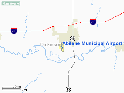
Abilene Municipal Airport |
Coordinates: 38°54â²15â³N 097°14â²09â³W / 38.90417°N 97.23583°W / 38.90417; -97.23583
| Abilene Municipal Airport |
| IATA: none â ICAO: none â FAA LID: K78 |
| Summary |
| Airport type |
Public |
| Owner |
City of Abilene |
| Serves |
Abilene, Kansas |
| Elevation AMSL |
1,152 ft / 351 m |
| Runways |
| Direction |
Length |
Surface |
| ft |
m |
| 17/35 |
4,100 |
1,250 |
Asphalt |
| Statistics (2007) |
| Aircraft operations |
35,800 |
| Based aircraft |
21 |
| Source: Federal Aviation Administration |
Abilene Municipal Airport (FAA LID: K78) is a city-owned public-use airport located one mile (1.6 km) southwest of the central business district of Abilene, a city in Dickinson County, Kansas, United States.
Facilities and aircraft
Abilene Municipal Airport covers an area of 195 acres (79 ha) which contains one runway designated 17/35 with a 4,100 x 75 ft (1,250 x 23 m) asphalt surface. For the 12-month period ending September 12, 2007, the airport had 35,800 aircraft operations, an average of 98 per day: 98% general aviation, 1% air taxi and 1% military. There are 21 aircraft based at this airport: 95% single-engine and 5% multi-engine.
The above content comes from Wikipedia and is published under free licenses – click here to read more.
|
Location &
QuickFacts
|
FAA
Information Effective: |
2008-06-05 |
|
Airport
Identifier: |
K78 |
|
Airport
Status: |
Operational |
|
Longitude/Latitude: |
097-14-09.0740W/38-54-14.6010N
-97.235854/38.904056 (Estimated) |
|
Elevation: |
1152 ft / 351.13 m (Surveyed) |
|
Land: |
195 acres |
|
From
nearest city: |
1 nautical miles SW of Abilene, KS |
|
Location: |
Dickinson County, KS |
|
Magnetic Variation: |
07E (1985) |
Owner & Manager
|
Ownership: |
Publicly owned |
|
Owner: |
City Of Abilene Kansas |
|
Address: |
City Building
Abilene, KS 67410 |
|
Phone
number: |
785-263-2550 |
|
Manager: |
Jim Curtis |
|
Address: |
801 S. Washington
Abilene, KS 67410 |
|
Phone
number: |
785-263-3970
FOR FUEL 785-479-2171 JIM CURTIS FBO. |
Airport
Operations and Facilities
|
Airport
Use: |
Open to public |
|
Wind
indicator: |
Yes |
|
Segmented Circle: |
No |
|
Control
Tower: |
No |
|
Lighting
Schedule: |
DUSK-DAWN
HIRL, PAPI AND REIL RY 17/35, OPER DUSK-2200; AFTER 2200 ACTVT CTAF. |
|
Beacon
Color: |
Clear-Green (lighted land airport) |
|
Landing
fee charge: |
No |
|
Sectional chart: |
Wichita |
|
Region: |
ACE - Central |
|
Boundary
ARTCC: |
ZKC - Kansas City |
|
Tie-in
FSS: |
ICT - Wichita |
|
FSS on
Airport: |
No |
|
FSS Toll
Free: |
1-800-WX-BRIEF |
|
NOTAMs
Facility: |
ICT (NOTAM-d service avaliable) |
|
Federal Agreements: |
NGY |
Airport Communications
|
CTAF: |
122.800 |
|
Unicom: |
122.800 |
Airport Services
|
Fuel
available: |
100LLA
FOR FUEL WHEN AIRPORT IS UNATTENDED CALL 785-479-2171. |
|
Airframe
Repair: |
MAJOR |
|
Power
Plant Repair: |
MAJOR |
|
Bottled
Oxygen: |
NONE |
|
Bulk
Oxygen: |
NONE |
|
Runway Information
Runway 17/35
|
Dimension: |
4100 x 75 ft / 1249.7 x 22.9 m |
|
Surface: |
ASPH, Good Condition
EXCESSIVE CRACKING WITH VEGETATION GROWING THRU CRACKS. |
|
Weight Limit: |
Single wheel: 13000 lbs.
Dual wheel: 16000 lbs. |
|
Edge Lights: |
High |
|
|
Runway 17
|
Runway 35
|
|
Longitude: |
097-14-09.0426W |
097-14-09.1069W |
|
Latitude: |
38-54-34.8628N |
38-53-54.3395N |
|
Elevation: |
1152.00 ft |
1149.00 ft |
|
Alignment: |
127 |
0 |
|
Traffic
Pattern: |
Left |
Left |
|
Markings: |
Non-precision instrument, Fair Condition |
Non-precision instrument, Fair Condition |
|
VASI: |
2-light PAPI on left side |
2-light PAPI on left side |
|
Runway End
Identifier: |
Yes |
Yes |
|
Obstruction: |
38 ft trees, 737.0 ft from runway, 96 ft right of
centerline, 14:1 slope to clear |
15 ft road, 650.0 ft from runway, 30:1 slope to clear |
|
Radio Navigation Aids
|
ID |
Type |
Name |
Ch |
Freq |
Var |
Dist |
|
CVY |
NDB |
Cavalry |
|
314.00 |
06E |
21.9 nm |
|
HRU |
NDB |
Herington |
|
407.00 |
06E |
23.6 nm |
|
CYW |
NDB |
Clay Center |
|
362.00 |
07E |
28.9 nm |
|
MQD |
NDB |
Mc Dowell Creek |
|
391.00 |
06E |
31.1 nm |
|
MPR |
NDB |
Mc Pherson |
|
227.00 |
06E |
39.6 nm |
|
CNK |
NDB |
Concordia |
|
335.00 |
06E |
43.6 nm |
|
FRI |
VOR |
Fort Riley |
|
109.40 |
06E |
18.0 nm |
|
MHK |
VOR/DME |
Manhattan |
039X |
110.20 |
06E |
30.2 nm |
|
SLN |
VORTAC |
Salina |
118X |
117.10 |
07E |
18.1 nm |
Remarks
Based Aircraft
|
Aircraft based
on field: |
21 |
|
Single Engine
Airplanes: |
20 |
|
Multi Engine
Airplanes: |
1 |
Operational Statistics
Time Period: 2006-09-13 - 2007-09-12
|
Aircraft
Operations: |
99/Day |
|
Air Taxi: |
1.4% |
|
General
Aviation Local: |
41.9% |
|
General
Aviation Itinerant: |
55.9% |
|
Military: |
0.8% |
Abilene Municipal Airport
Address:
Dickinson County, KS
Tel:
785-263-2550,
785-263-3970
Images
and information placed above are from
http://www.airport-data.com/airport/K78/
We
thank them for the data!
|
General Info |
| Country |
United
States |
| State |
KANSAS
|
| FAA ID |
K78
|
| Latitude |
38-54-14.601N |
|
Longitude |
097-14-09.074W |
|
Elevation |
1152
feet |
| Near
City |
ABILENE
|
We don't guarantee the information is fresh and accurate. The data may
be wrong or outdated.
For more up-to-date information please refer to other sources.
|
|


