 |
|
|
|
|
|
Location &
QuickFacts
|
FAA
Information Effective: |
2007-07-05 |
|
Airport
Identifier: |
IA62 |
|
Airport
Status: |
Operational |
|
Longitude/Latitude: |
095-04-30.9660W/41-31-59.9600N
-95.075268/41.533322 (Estimated) |
|
Elevation: |
1310 ft / 399.29 m (Estimated) |
|
Land: |
0 acres |
|
From
nearest city: |
5 nautical miles SW of Elkhorn, IA |
|
Location: |
Shelby County, IA |
|
Magnetic Variation: |
05E (1985) |
Owner & Manager
|
Ownership: |
Privately owned |
|
Owner: |
Lester W. Wheatley |
|
Address: |
2609 200th Street
Marne, IA 51552-2100 |
|
Phone number: |
712-764-8423 |
|
Manager: |
Lester W. & Wayne Wheatley |
|
Address: |
2609 200th Street
Marne, IA 51552-2100 |
|
Phone number: |
712-781-2306
712-784-3929 OR 712-784-2351 |
Airport Operations and Facilities
|
Airport Use: |
Private |
|
Wind indicator: |
Yes |
|
Segmented Circle: |
No |
|
Control Tower: |
No |
|
Landing fee charge: |
No |
|
Sectional chart: |
Omaha |
|
Region: |
ACE - Central |
|
Boundary ARTCC: |
ZMP - Minneapolis |
|
Tie-in FSS: |
FOD - Fort Dodge |
|
FSS on Airport: |
No |
|
FSS Phone: |
515-955-8114 |
|
FSS Toll Free: |
1-800-WX-BRIEF |
Airport Services
|
Airframe
Repair: |
NONE |
|
Power
Plant Repair: |
NONE |
|
Runway
Information
Runway N/S
|
Dimension: |
1800 x 100 ft / 548.6 x 30.5 m |
|
Surface: |
TURF, |
|
|
Runway N
|
Runway S
|
|
Traffic
Pattern: |
Left |
Left |
|
Radio Navigation Aids
|
ID |
Type |
Name |
Ch |
Freq |
Var |
Dist |
|
AIO |
NDB |
Atlantic |
|
365.00 |
04E |
7.9 nm |
|
ADU |
NDB |
Audubon |
|
266.00 |
04E |
12.0 nm |
|
HNR |
NDB |
Harlan |
|
272.00 |
05E |
12.2 nm |
|
GCT |
NDB |
Guthrie Center |
|
518.00 |
05E |
30.2 nm |
|
DNS |
NDB |
Denison |
|
350.00 |
04E |
30.3 nm |
|
GFZ |
NDB |
Greenfield |
|
338.00 |
04E |
31.1 nm |
|
RDK |
NDB |
Red Oak |
|
230.00 |
04E |
32.1 nm |
|
CIN |
NDB |
Carroll |
|
397.00 |
04E |
33.4 nm |
|
CRZ |
NDB |
Corning |
|
278.00 |
04E |
35.3 nm |
|
OM |
NDB |
Gerfi |
|
320.00 |
05E |
40.9 nm |
|
EFW |
NDB |
Jefferson |
|
391.00 |
03E |
43.7 nm |
|
PRO |
NDB |
Perry |
|
251.00 |
06E |
44.8 nm |
|
UNE |
NDB |
Union County |
|
379.00 |
04E |
47.8 nm |
|
ICL |
NDB |
Clarinda |
|
353.00 |
04E |
48.5 nm |
|
SDA |
NDB |
Shenandoah |
|
411.00 |
05E |
49.3 nm |
|
OFF |
TACAN |
Offutt |
054X |
|
05E |
44.8 nm |
|
OVR |
VORTAC |
Omaha |
110X |
116.30 |
08E |
37.1 nm |
|
OMA |
VOT |
Omaha |
|
109.00 |
|
39.3 nm |
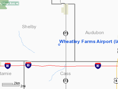
Wheatley Farms Airport
Address:
Shelby County, IA
Tel:
712-764-8423, 712-781-2306, 712-784-3929, 712-784-2351
Images
and information placed above are from
http://www.airport-data.com/airport/IA62/
We
thank them for the data!
|
General Info |
| Country |
United
States |
| State |
IOWA
|
| FAA ID |
IA62
|
| Latitude |
41-31-59.960N |
|
Longitude |
095-04-30.966W |
|
Elevation |
1310
feet |
| Near
City |
ELKHORN
|
We don't guarantee the information is fresh and accurate. The data may
be wrong or outdated.
For more up-to-date information please refer to other sources.
|
|


