 |
|
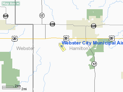
Webster City Municipal Airport |
|
|
Location &
QuickFacts
|
FAA
Information Effective: |
2007-07-05 |
|
Airport
Identifier: |
EBS |
|
Airport
Status: |
Operational |
|
Longitude/Latitude: |
093-52-07.9000W/42-26-11.9000N
-93.868861/42.436639 (Estimated) |
|
Elevation: |
1121 ft / 341.68 m (Surveyed) |
|
Land: |
181 acres |
|
From
nearest city: |
3 nautical miles SW of Webster City, IA |
|
Location: |
Hamilton County, IA |
|
Magnetic Variation: |
03E (1995) |
Owner & Manager
|
Ownership: |
Publicly owned |
|
Owner: |
City Of Webster City
CHAIRMAN ARPT CMSN STEVE SAVERE. |
|
Address: |
400 2nd St.
Webster City, IA 50595-0217 |
|
Phone
number: |
515-832-5701 |
|
Manager: |
Ralph Storm |
|
Address: |
1524 - 240th St
Webster City, IA 50595 |
|
Phone number: |
515-832-3723 |
Airport Operations and Facilities
|
Airport
Use: |
Open to public |
|
Wind
indicator: |
Yes |
|
Segmented Circle: |
No |
|
Control
Tower: |
No |
|
Lighting
Schedule: |
DUSK-DAWN
ACTVT MIRL RY 14/32; SAVASIS & REILS RY 14 & 32 - CTAF. |
|
Beacon
Color: |
Clear-Green (lighted land airport) |
|
Landing
fee charge: |
No |
|
Sectional chart: |
Omaha |
|
Region: |
ACE - Central |
|
Boundary
ARTCC: |
ZMP - Minneapolis |
|
Tie-in
FSS: |
FOD - Fort Dodge |
|
FSS on
Airport: |
No |
|
FSS
Phone: |
515-955-8114 |
|
FSS Toll
Free: |
1-800-WX-BRIEF |
|
NOTAMs
Facility: |
EBS (NOTAM-d service avaliable) |
|
Federal Agreements: |
NY1 |
Airport Communications
|
CTAF: |
122.800 |
|
Unicom: |
122.800 |
Airport Services
|
Fuel
available: |
100LLA |
|
Airframe
Repair: |
MAJOR |
|
Power
Plant Repair: |
MAJOR |
|
Bottled
Oxygen: |
NONE |
|
Bulk
Oxygen: |
NONE |
|
Runway Information
Runway 05/23
|
Dimension: |
2655 x 90 ft / 809.2 x 27.4 m |
|
Surface: |
TURF, Fair Condition |
|
|
Runway 05
|
Runway 23
|
|
Longitude: |
093-52-20.0000W |
093-51-53.3000W |
|
Latitude: |
42-26-06.1000N |
42-26-24.1000N |
|
Traffic
Pattern: |
Left |
Left |
|
Obstruction: |
4 ft fence, 105.0 ft from runway, 26:1 slope to clear |
5 ft pole, 115.0 ft from runway, 51 ft left of centerline,
23:1 slope to clear |
|
Runway 14/32
|
Dimension: |
4007 x 75 ft / 1221.3 x 22.9 m |
|
Surface: |
CONC, Good Condition |
|
Weight Limit: |
Single wheel: 15000 lbs. |
|
Edge Lights: |
Non-standard lighting system
RY 14/32 - NSTD MIRL; LAST 1,000 FT ON EACH END OF RY LGTS CLEAR. |
|
|
Runway 14
|
Runway 32
|
|
Longitude: |
093-52-23.7980W |
093-51-52.3700W |
|
Latitude: |
42-26-25.8160N |
42-25-53.8090N |
|
Elevation: |
1104.00 ft |
1121.00 ft |
|
Alignment: |
127 |
127 |
|
Traffic
Pattern: |
Left |
Left |
|
Markings: |
Non-precision instrument, Good Condition |
Non-precision instrument, Good Condition |
|
VASI: |
2-box SAVASI on left side
VASI OTS INDEFLY. |
2-box SAVASI on left side |
|
Runway End
Identifier: |
Yes
REIL OTS INDEFLY. |
Yes |
|
Obstruction: |
19 ft road, 400.0 ft from runway, 205 ft left of
centerline, 10:1 slope to clear |
4 ft fence, 293.0 ft from runway, 23:1 slope to clear |
|
Radio Navigation Aids
|
ID |
Type |
Name |
Ch |
Freq |
Var |
Dist |
|
EBS |
NDB |
Webster City |
|
323.00 |
03E |
0.3 nm |
|
EAG |
NDB |
Eagle Grove |
|
302.00 |
03E |
16.4 nm |
|
CAV |
NDB |
Clarion |
|
387.00 |
03E |
19.2 nm |
|
BNW |
NDB |
Boone |
|
407.00 |
03E |
23.0 nm |
|
IFA |
NDB |
Iowa Falls |
|
368.00 |
03E |
26.9 nm |
|
EFW |
NDB |
Jefferson |
|
391.00 |
03E |
33.0 nm |
|
HPT |
NDB |
Hampton |
|
230.00 |
03E |
33.4 nm |
|
PRO |
NDB |
Perry |
|
251.00 |
06E |
38.7 nm |
|
POH |
NDB |
Pocahontas |
|
428.00 |
06E |
39.2 nm |
|
AXA |
NDB |
Algona |
|
403.00 |
03E |
42.6 nm |
|
IKV |
NDB |
Ankeny |
|
275.00 |
03E |
46.4 nm |
|
MIW |
NDB |
Marshalltown |
|
239.00 |
03E |
46.7 nm |
|
CIN |
NDB |
Carroll |
|
397.00 |
04E |
47.1 nm |
|
FXY |
NDB |
Forest City |
|
359.00 |
05E |
49.2 nm |
|
SKI |
NDB |
Sac City |
|
356.00 |
04E |
49.5 nm |
|
JWJ |
VOR/DME |
Elmwood |
031X |
109.40 |
03E |
47.0 nm |
|
FOD |
VORTAC |
Fort Dodge |
082X |
113.50 |
07E |
21.6 nm |
|
MCW |
VORTAC |
Mason City |
096X |
114.90 |
06E |
46.2 nm |
Remarks
-
CTN: ULTRALIGHT
ACTIVITY ON & INVOF ARPT.
-
RY 32 IS CALM
WIND RY.
-
CONDL-PRVD THE
APCH TO EACH RWY IS MAINTAINED FOR A MINIMUM 20:1 GLIDE SLOPE AND THE
TRANSITIONAL SURFACE BE MAINTAINED FOR A 7:1 SLOPE.
Based
Aircraft
|
Aircraft based
on field: |
23 |
|
Single Engine
Airplanes: |
15 |
|
Multi Engine
Airplanes: |
8 |
Operational Statistics
Time Period:
2003-07-21 -
2004-07-19
|
Aircraft
Operations: |
58/Day |
|
Air Taxi: |
1.5% |
|
General
Aviation Local: |
63.4% |
|
General
Aviation Itinerant: |
35.1% |
Webster City Municipal Airport
Address:
Hamilton County, IA
Tel:
515-832-5701,
515-832-3723
Images
and information placed above are from
http://www.airport-data.com/airport/EBS/
We
thank them for the data!
|
General Info |
| Country |
United
States |
| State |
IOWA
|
| FAA ID |
EBS
|
| Latitude |
42-26-11.900N |
|
Longitude |
093-52-07.900W |
|
Elevation |
1121
feet |
| Near
City |
WEBSTER
CITY |
We don't guarantee the information is fresh and accurate. The data may
be wrong or outdated.
For more up-to-date information please refer to other sources.
|
|


