 |
|
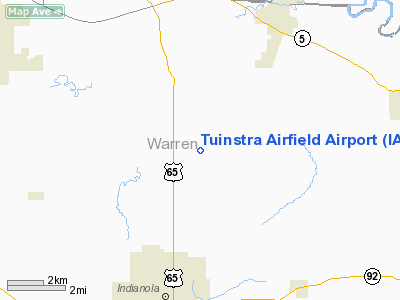
Tuinstra Airfield Airport |
Location &
QuickFacts
|
FAA
Information Effective: |
2007-07-05 |
|
Airport
Identifier: |
IA85 |
|
Airport
Status: |
Operational |
|
Longitude/Latitude: |
093-32-25.7740W/41-26-06.4680N
-93.540493/41.435130 (Estimated) |
|
Elevation: |
900 ft / 274.32 m (Estimated) |
|
Land: |
40 acres |
|
From
nearest city: |
6 nautical miles N of Indianola, IA |
|
Location: |
Warren County, IA |
|
Magnetic Variation: |
03E (1995) |
Owner & Manager
|
Ownership: |
Privately owned |
|
Owner: |
J. Lucian Tuinstra |
|
Address: |
1399 Fairfax
Indianola, IA 50125 |
|
Phone number: |
515-961-6240 |
|
Manager: |
J. Lucian Tuinstra |
|
Address: |
1399 Fairfax
Indianola, IA 50125 |
|
Phone number: |
515-961-6240 |
Airport
Operations and Facilities
|
Airport
Use: |
Private |
|
Wind
indicator: |
Yes |
|
Segmented Circle: |
No |
|
Control
Tower: |
No |
|
Region: |
ACE - Central |
|
Boundary
ARTCC: |
ZMP - Minneapolis |
|
Tie-in
FSS: |
FOD - Fort Dodge |
|
FSS
Phone: |
515-955-8114 |
|
FSS Toll
Free: |
1-800-WX-BRIEF |
|
Runway Information
Runway 11/29
|
Dimension: |
1200 x 75 ft / 365.8 x 22.9 m |
|
Surface: |
TURF, |
|
|
Runway 11
|
Runway 29
|
|
Traffic
Pattern: |
Left |
Left |
|
Obstruction: |
|
35 ft pline, 400.0 ft from runway |
|
Radio Navigation Aids
|
ID |
Type |
Name |
Ch |
Freq |
Var |
Dist |
|
IKV |
NDB |
Ankeny |
|
275.00 |
03E |
15.9 nm |
|
OXV |
NDB |
Knoxville |
|
284.00 |
03E |
21.0 nm |
|
CNC |
NDB |
Chariton |
|
335.00 |
05E |
26.4 nm |
|
PEA |
NDB |
Pella |
|
257.00 |
02E |
27.0 nm |
|
PRO |
NDB |
Perry |
|
251.00 |
06E |
36.6 nm |
|
BNW |
NDB |
Boone |
|
407.00 |
03E |
39.8 nm |
|
GGI |
NDB |
Grinnell |
|
248.00 |
02E |
40.0 nm |
|
GFZ |
NDB |
Greenfield |
|
338.00 |
04E |
41.3 nm |
|
GCT |
NDB |
Guthrie Center |
|
518.00 |
05E |
42.8 nm |
|
UNE |
NDB |
Union County |
|
379.00 |
04E |
46.4 nm |
|
OOA |
NDB |
Oskaloosa |
|
414.00 |
03E |
49.2 nm |
|
MIW |
NDB |
Marshalltown |
|
239.00 |
03E |
49.3 nm |
|
TNU |
VOR/DME |
Newton |
072X |
112.50 |
03E |
28.6 nm |
|
JWJ |
VOR/DME |
Elmwood |
031X |
109.40 |
03E |
49.5 nm |
|
DSM |
VORTAC |
Des Moines |
122X |
117.50 |
07E |
4.9 nm |
|
DSM |
VOT |
Des Moines |
|
109.20 |
|
8.6 nm |
Remarks
-
OWNER DESIRES
ARPT NOT BE CHARTED.
-
PRVDD A CLEAR
APCH TO EA RY FOR A 20:1 GLIDE SLOPE & A CLEAR TRANSITIONAL SFC FOR A 7:1
SLOPE.
Based
Aircraft
|
Aircraft based
on field: |
1 |
|
Single Engine
Airplanes: |
1 |
Tuinstra Airfield Airport
Address:
Warren County, IA
Tel:
515-961-6240
Images
and information placed above are from
http://www.airport-data.com/airport/IA85/
We
thank them for the data!
|
General Info |
| Country |
United
States |
| State |
IOWA
|
| FAA ID |
IA85
|
| Latitude |
41-26-06.468N |
|
Longitude |
093-32-25.774W |
|
Elevation |
900 feet
|
| Near
City |
INDIANOLA |
We don't guarantee the information is fresh and accurate. The data may
be wrong or outdated.
For more up-to-date information please refer to other sources.
|
|


