 |
|
|
|
|
|
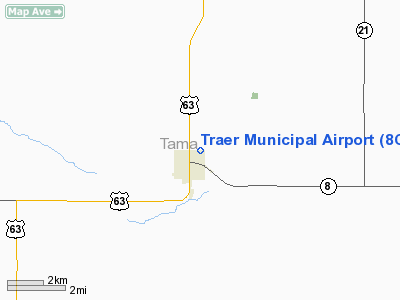
Location &
QuickFacts
|
FAA
Information Effective: |
2007-07-05 |
|
Airport
Identifier: |
8C6 |
|
Airport
Status: |
Operational |
|
Longitude/Latitude: |
092-27-28.6870W/42-11-56.9620N
-92.457969/42.199156 (Estimated) |
|
Elevation: |
892 ft / 271.88 m (Estimated) |
|
Land: |
11 acres |
|
From
nearest city: |
1 nautical miles NE of Traer, IA |
|
Location: |
Tama County, IA |
|
Magnetic Variation: |
03E (1985) |
Owner & Manager
|
Ownership: |
Publicly owned |
|
Owner: |
City Of Traer |
|
Address: |
649 2nd St
Traer, IA 50675 |
|
Phone
number: |
319-478-2580 |
|
Manager: |
Melvin Herink
ALSO JIM PIPPERT |
|
Address: |
2448 160th St
Traer, IA 50675 |
|
Phone number: |
319-478-2154 |
Airport
Operations and Facilities
|
Airport
Use: |
Open to public |
|
Wind
indicator: |
Yes |
|
Segmented Circle: |
No |
|
Control
Tower: |
No |
|
Lighting
Schedule: |
DUSK-DAWN |
|
Landing
fee charge: |
No |
|
Sectional chart: |
Chicago |
|
Region: |
ACE - Central |
|
Boundary
ARTCC: |
ZAU - Chicago |
|
Tie-in
FSS: |
FOD - Fort Dodge |
|
FSS on
Airport: |
No |
|
FSS
Phone: |
515-955-8114 |
|
FSS Toll
Free: |
1-800-WX-BRIEF |
|
NOTAMs
Facility: |
FOD (NOTAM-d service avaliable) |
Airport Communications
Airport Services
|
Airframe
Repair: |
NONE |
|
Power
Plant Repair: |
NONE |
|
Bottled
Oxygen: |
NONE |
|
Bulk
Oxygen: |
NONE |
|
Runway Information
Runway 17/35
|
Dimension: |
2555 x 100 ft / 778.8 x 30.5 m |
|
Surface: |
TURF, Good Condition |
|
Edge Lights: |
Low |
|
|
Runway 17
|
Runway 35
|
|
Traffic
Pattern: |
Left |
Right |
|
Obstruction: |
61 ft trees, 848.0 ft from runway, 200 ft left of
centerline, 13:1 slope to clear |
66 ft tree, 1677.0 ft from runway, 50 ft right of
centerline, 25:1 slope to clear |
|
Radio Navigation Aids
|
ID |
Type |
Name |
Ch |
Freq |
Var |
Dist |
|
VTI |
NDB |
Garrison |
|
338.00 |
03E |
19.5 nm |
|
TZT |
NDB |
Belle Plaine |
|
371.00 |
02E |
20.4 nm |
|
MIW |
NDB |
Marshalltown |
|
239.00 |
03E |
21.1 nm |
|
IIB |
NDB |
Wapsie |
|
206.00 |
02E |
27.2 nm |
|
GGI |
NDB |
Grinnell |
|
248.00 |
02E |
31.8 nm |
|
OLZ |
NDB |
Oelwein |
|
260.00 |
02E |
36.1 nm |
|
IFA |
NDB |
Iowa Falls |
|
368.00 |
03E |
39.6 nm |
|
HPT |
NDB |
Hampton |
|
230.00 |
03E |
46.5 nm |
|
JWJ |
VOR/DME |
Elmwood |
031X |
109.40 |
03E |
20.8 nm |
|
CID |
VOR/DME |
Cedar Rapids |
088X |
114.10 |
05E |
35.4 nm |
|
TNU |
VOR/DME |
Newton |
072X |
112.50 |
03E |
38.3 nm |
|
ALO |
VORTAC |
Waterloo |
059X |
112.20 |
06E |
21.6 nm |
Remarks
-
SNOW RMVL DELAYED
AT TIMES; CONFIRM RY COND PRIOR TO USE - CALL 319-478-2580 OR 319-478-2154
-
TURF RY SOFT
DURING SPRING THAW.
-
PARALLEL TWY IS
MKD AND LGTD ALONG EAST EDGE.
Based
Aircraft
|
Aircraft based
on field: |
9 |
|
Single Engine
Airplanes: |
9 |
Operational Statistics
Time Period:
2005-09-27 -
2006-09-26
|
Aircraft
Operations: |
79/Week |
|
General
Aviation Local: |
51.2% |
|
General
Aviation Itinerant: |
48.8% |
Traer Municipal Airport
Address:
Tama County, IA
Tel:
319-478-2580,
319-478-2154
Images
and information placed above are from
http://www.airport-data.com/airport/8C6/
We
thank them for the data!
|
General Info |
| Country |
United
States |
| State |
IOWA
|
| FAA ID |
8C6
|
| Latitude |
42-11-56.962N |
|
Longitude |
092-27-28.687W |
|
Elevation |
892 feet
|
| Near
City |
TRAER
|
We don't guarantee the information is fresh and accurate. The data may
be wrong or outdated.
For more up-to-date information please refer to other sources.
|
|


