 |
|
Spirit Lake Municipal Airport |
|
|
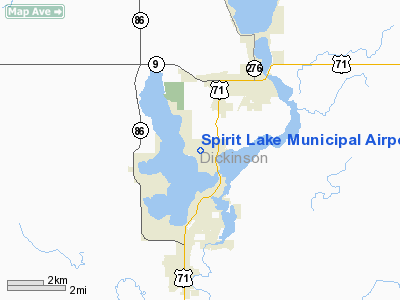
Location &
QuickFacts
|
FAA
Information Effective: |
2007-07-05 |
|
Airport
Identifier: |
0F3 |
|
Airport
Status: |
Operational |
|
Longitude/Latitude: |
095-08-20.9840W/43-23-14.8670N
-95.139162/43.387463 (Estimated) |
|
Elevation: |
1434 ft / 437.08 m (Surveyed) |
|
Land: |
65 acres |
|
From
nearest city: |
3 nautical miles SW of Spirit Lake, IA |
|
Location: |
Dickinson County, IA |
|
Magnetic Variation: |
05E (1985) |
Owner & Manager
|
Ownership: |
Publicly owned |
|
Owner: |
Dickinson County Arpt Auth
ARPT AUTHORITY CHAIRMAN - BRUCE SMITH - 712-332-7323. |
|
Address: |
Box 702
Okoboji, IA 51355 |
|
Phone
number: |
712-332-9412 |
|
Manager: |
Dickinson County Arpt Auth
BRUCE SMITH |
|
Address: |
Box 702
Okoboji, IA 51355 |
|
Phone number: |
712-332-9412 |
Airport
Operations and Facilities
|
Airport
Use: |
Open to public |
|
Wind
indicator: |
Yes |
|
Segmented Circle: |
No |
|
Control
Tower: |
No |
|
Lighting
Schedule: |
DUSK-DAWN
ACTVT REIL RY 16 - CTAF. |
|
Landing
fee charge: |
Yes |
|
Sectional chart: |
Omaha |
|
Region: |
ACE - Central |
|
Boundary
ARTCC: |
ZMP - Minneapolis |
|
Tie-in
FSS: |
FOD - Fort Dodge |
|
FSS on
Airport: |
No |
|
FSS
Phone: |
515-955-8114 |
|
FSS Toll
Free: |
1-800-WX-BRIEF |
|
NOTAMs
Facility: |
FOD (NOTAM-d service avaliable) |
Airport Communications
|
CTAF: |
122.700 |
|
Unicom: |
122.700 |
Airport Services
|
Bottled
Oxygen: |
NONE |
|
Bulk
Oxygen: |
NONE |
|
Runway Information
Runway 16/34
|
Dimension: |
3015 x 50 ft / 919.0 x 15.2 m |
|
Surface: |
ASPH, Fair Condition |
|
Edge Lights: |
Low
RY 16 REIL PCL OTS INDEFLY; REIL ON LOW INTST CONTINUOUSLY. |
|
|
Runway 16
|
Runway 34
|
|
Longitude: |
095-08-25.7282W |
095-08-16.2398W |
|
Latitude: |
43-23-29.3484N |
43-23-00.3856N |
|
Elevation: |
1434.00 ft |
1420.00 ft |
|
Alignment: |
127 |
127 |
|
Traffic
Pattern: |
Left |
Left |
|
Markings: |
Basic, Good Condition |
Basic, Good Condition |
|
Runway End
Identifier: |
Yes |
|
|
Obstruction: |
40 ft trees, 570.0 ft from runway, 100 ft left of
centerline, 20:1 slope to clear
+30' TREES 100' RIGHT OF RWY CNTRLN EXTNDD 520' FROM AER. |
40 ft tree, 705.0 ft from runway, 45 ft right of
centerline, 12:1 slope to clear |
|
Radio Navigation Aids
|
ID |
Type |
Name |
Ch |
Freq |
Var |
Dist |
|
LTU |
NDB |
Little Sioux |
|
326.00 |
05E |
15.7 nm |
|
MJQ |
NDB |
Jackson |
|
353.00 |
04E |
17.0 nm |
|
PUF |
NDB |
Puff |
|
345.00 |
04E |
17.7 nm |
|
EGQ |
NDB |
Emmetsburg |
|
410.00 |
04E |
25.6 nm |
|
ISB |
NDB |
Sibley |
|
269.00 |
05E |
26.8 nm |
|
MWM |
NDB |
Windom |
|
203.00 |
03E |
31.4 nm |
|
SHL |
NDB |
Sheldon |
|
338.00 |
05E |
32.1 nm |
|
AXA |
NDB |
Algona |
|
403.00 |
03E |
42.2 nm |
|
CKP |
NDB |
Pilot Rock |
|
423.00 |
05E |
43.4 nm |
|
JYG |
NDB |
St James |
|
260.00 |
04E |
44.1 nm |
|
POH |
NDB |
Pocahontas |
|
428.00 |
06E |
44.1 nm |
|
ORC |
NDB |
Orange City |
|
521.00 |
05E |
46.9 nm |
|
SBU |
NDB |
Blue Earth |
|
332.00 |
04E |
47.2 nm |
|
SLB |
NDB |
Storm Lake |
|
434.00 |
04E |
47.5 nm |
|
SOY |
NDB |
Sioux Center |
|
368.00 |
06E |
48.5 nm |
|
EST |
VOR |
Estherville |
|
110.40 |
07E |
17.3 nm |
|
SPW |
VOR/DME |
Spencer |
037X |
110.00 |
05E |
13.8 nm |
|
OTG |
VOR/DME |
Worthington |
043X |
110.60 |
08E |
24.8 nm |
|
DDL |
VOR/DME |
Sheldon |
023X |
108.60 |
05E |
32.2 nm |
|
FRM |
VOR/DME |
Fairmont |
039X |
110.20 |
07E |
34.9 nm |
Based Aircraft
|
Aircraft based
on field: |
12 |
|
Single Engine
Airplanes: |
11
BASED ACFT 40 SEASONALLY MAY-SEP. |
|
Multi Engine
Airplanes: |
1 |
Operational Statistics
Time Period:
2005-07-27 -
2006-07-26
|
Aircraft
Operations: |
113/Week |
|
General
Aviation Local: |
43.2% |
|
General
Aviation Itinerant: |
56.8% |
Spirit Lake Municipal Airport
Address:
Dickinson County, IA
Tel:
712-332-9412
Images
and information placed above are from
http://www.airport-data.com/airport/0F3/
We
thank them for the data!
|
General Info |
| Country |
United
States |
| State |
IOWA
|
| FAA ID |
0F3
|
| Latitude |
43-23-14.867N |
|
Longitude |
095-08-20.984W |
|
Elevation |
1434
feet |
| Near
City |
SPIRIT
LAKE |
We don't guarantee the information is fresh and accurate. The data may
be wrong or outdated.
For more up-to-date information please refer to other sources.
|
|


