 |
|
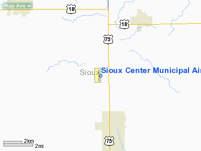
Sioux Center Municipal Airport |
|
|
Location &
QuickFacts
|
FAA
Information Effective: |
2007-07-05 |
|
Airport
Identifier: |
SOY |
|
Airport
Status: |
Operational |
|
Longitude/Latitude: |
096-11-15.0660W/43-08-03.9720N
-96.187518/43.134437 (Estimated) |
|
Elevation: |
1448 ft / 441.35 m (Surveyed) |
|
Land: |
160 acres |
|
From
nearest city: |
3 nautical miles N of Sioux Center, IA |
|
Location: |
Sioux County, IA |
|
Magnetic Variation: |
05E (1995) |
Owner & Manager
|
Ownership: |
Publicly owned |
|
Owner: |
Sioux Center |
|
Address: |
City Hall 337 N Main
Sioux Center, IA 51520 |
|
Phone
number: |
712-722-0761 |
|
Manager: |
Randy Vander Weide |
|
Address: |
3028 360th Street
Sioux Center, IA 51520 |
|
Phone number: |
712-722-2293 |
Airport Operations and Facilities
|
Airport
Use: |
Open to public |
|
Wind
indicator: |
Yes |
|
Segmented Circle: |
No |
|
Control
Tower: |
No |
|
Lighting
Schedule: |
RDO-CTL
ACTVT MIRL RY 18/36 - CTAF. |
|
Landing
fee charge: |
No |
|
Sectional chart: |
Omaha |
|
Region: |
ACE - Central |
|
Boundary
ARTCC: |
ZMP - Minneapolis |
|
Tie-in
FSS: |
FOD - Fort Dodge |
|
FSS on
Airport: |
No |
|
FSS
Phone: |
515-955-8114 |
|
FSS Toll
Free: |
1-800-WX-BRIEF |
|
NOTAMs
Facility: |
FOD (NOTAM-d service avaliable) |
Airport Communications
|
CTAF: |
122.800 |
|
Unicom: |
122.800 |
Airport Services
|
Fuel
available: |
100LL |
|
Airframe
Repair: |
MINOR |
|
Power
Plant Repair: |
MINOR |
|
Bottled
Oxygen: |
NONE |
|
Bulk
Oxygen: |
NONE |
|
Runway Information
Runway 18/36
|
Dimension: |
3802 x 50 ft / 1158.8 x 15.2 m |
|
Surface: |
CONC, Good Condition |
|
Edge Lights: |
Medium
NSTD MIRL; LGTS 30 FT FROM PAVEMENT EDGE & RY 35 HAS ONLY 6 THLD LGTS. |
|
|
Runway 18
|
Runway 36
|
|
Longitude: |
096-11-15.4820W |
096-11-14.6500W |
|
Latitude: |
43-08-22.7450N |
43-07-45.1980N |
|
Elevation: |
1448.00 ft |
1444.00 ft |
|
Alignment: |
127 |
127 |
|
Traffic
Pattern: |
Left |
Left |
|
Markings: |
Non-precision instrument, Good Condition |
Non-precision instrument, Good Condition |
|
Obstruction: |
23 ft rr, 200.0 ft from runway, 250 ft left of centerline |
15 ft road, 490.0 ft from runway, 19:1 slope to clear |
|
Radio Navigation Aids
|
ID |
Type |
Name |
Ch |
Freq |
Var |
Dist |
|
SOY |
NDB |
Sioux Center |
|
368.00 |
06E |
0.1 nm |
|
ORC |
NDB |
Orange City |
|
521.00 |
05E |
10.2 nm |
|
SHL |
NDB |
Sheldon |
|
338.00 |
05E |
16.2 nm |
|
ISB |
NDB |
Sibley |
|
269.00 |
05E |
23.7 nm |
|
FS |
NDB |
Rokky |
|
245.00 |
06E |
35.4 nm |
|
CKP |
NDB |
Pilot Rock |
|
423.00 |
05E |
36.9 nm |
|
VMR |
NDB |
Vermillion |
|
375.00 |
06E |
39.7 nm |
|
OI |
NDB |
Tommi |
|
305.00 |
07E |
42.3 nm |
|
GAK |
NDB |
Sioux Gateway |
|
233.00 |
06E |
44.5 nm |
|
LTU |
NDB |
Little Sioux |
|
326.00 |
05E |
46.3 nm |
|
SU |
NDB |
Salix |
|
414.00 |
07E |
48.7 nm |
|
DDL |
VOR/DME |
Sheldon |
023X |
108.60 |
05E |
16.2 nm |
|
OTG |
VOR/DME |
Worthington |
043X |
110.60 |
08E |
40.6 nm |
|
SPW |
VOR/DME |
Spencer |
037X |
110.00 |
05E |
43.3 nm |
|
FSD |
VORTAC |
Sioux Falls |
097X |
115.00 |
09E |
40.4 nm |
|
SUX |
VORTAC |
Sioux City |
112X |
116.50 |
09E |
47.9 nm |
Remarks
-
RY 36 LGTD +80 FT
SILO AT 700 FT & 321 FT L CNTRLN EXTDD.
Based
Aircraft
|
Aircraft based
on field: |
13 |
|
Single Engine
Airplanes: |
9 |
|
Multi Engine
Airplanes: |
4 |
Operational Statistics
Time Period:
2004-09-19 -
2005-09-18
|
Aircraft
Operations: |
113/Week |
|
Air Taxi: |
12.0% |
|
General
Aviation Local: |
71.5% |
|
General
Aviation Itinerant: |
16.4% |
|
Military: |
0.2% |
Sioux Center Municipal Airport
Address:
Sioux County, IA
Tel:
712-722-0761,
712-722-2293
Images
and information placed above are from
http://www.airport-data.com/airport/SOY/
We
thank them for the data!
|
General Info |
| Country |
United
States |
| State |
IOWA
|
| FAA ID |
SOY
|
| Latitude |
43-08-03.972N |
|
Longitude |
096-11-15.066W |
|
Elevation |
1448
feet |
| Near
City |
SIOUX
CENTER |
We don't guarantee the information is fresh and accurate. The data may
be wrong or outdated.
For more up-to-date information please refer to other sources.
|
|


