 |
|
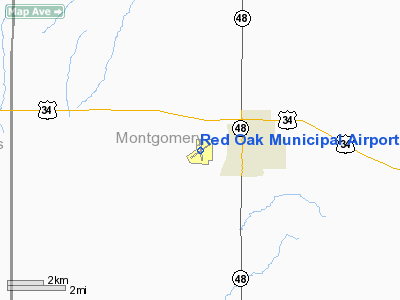
Red Oak Municipal Airport |
|
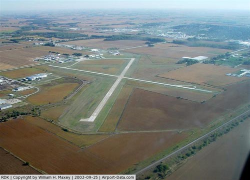 |
(Click on the photo to enlarge) |
Location & QuickFacts
|
FAA Information Effective: |
2007-07-05 |
|
Airport Identifier: |
RDK |
|
Airport Status: |
Operational |
|
Longitude/Latitude: |
095-15-35.5000W/41-00-37.9000N
-95.259861/41.010528 (Estimated) |
|
Elevation: |
1044 ft / 318.21 m (Surveyed) |
|
Land: |
202 acres |
|
From nearest city: |
2 nautical miles W of Red Oak, IA |
|
Location: |
Montgomery County, IA |
|
Magnetic Variation: |
05E (1995) |
Owner & Manager
|
Ownership: |
Publicly owned |
|
Owner: |
City Of Red Oak
JOHN SWANSON - CHMN - (712) 623-2283. |
|
Address: |
601 6th St
Red Oak, IA 51566 |
|
Phone
number: |
712-623-6523 |
|
Manager: |
Howard Viner |
|
Address: |
1674 200th St
Red Oak, IA 51566 |
|
Phone number: |
712-623-6523 |
Airport Operations and Facilities
|
Airport
Use: |
Open to public |
|
Wind
indicator: |
Yes |
|
Segmented Circle: |
Yes |
|
Control
Tower: |
No |
|
Lighting
Schedule: |
DUSK-DAWN
ACTVT MIRL RYS 17/35 & 05/23; PLASI RYS 05 & 23 AND REIL RYS 05 & 23
AND SAVASI RYS 17 & 35 - CTAF. |
|
Beacon
Color: |
Clear-Green (lighted land airport) |
|
Landing
fee charge: |
No |
|
Sectional chart: |
Omaha |
|
Region: |
ACE - Central |
|
Boundary
ARTCC: |
ZMP - Minneapolis |
|
Tie-in
FSS: |
FOD - Fort Dodge |
|
FSS on
Airport: |
No |
|
FSS
Phone: |
515-955-8114 |
|
FSS Toll
Free: |
1-800-WX-BRIEF |
|
NOTAMs
Facility: |
RDK (NOTAM-d service avaliable) |
|
Federal Agreements: |
NGY |
Airport Communications
|
CTAF: |
122.800 |
|
Unicom: |
122.800 |
Airport Services
|
Fuel
available: |
100LLA |
|
Airframe
Repair: |
MAJOR |
|
Power
Plant Repair: |
MAJOR |
|
Bottled
Oxygen: |
NONE |
|
Bulk
Oxygen: |
NONE |
|
Runway Information
Runway 05/23
|
Dimension: |
4100 x 75 ft / 1249.7 x 22.9 m |
|
Surface: |
CONC, Good Condition |
|
Edge Lights: |
Medium |
|
|
Runway 05
|
Runway 23
|
|
Longitude: |
095-16-00.1740W |
095-15-14.8770W |
|
Latitude: |
41-00-25.3330N |
41-00-46.8640N |
|
Elevation: |
1042.00 ft |
1043.00 ft |
|
Alignment: |
58 |
127 |
|
Traffic
Pattern: |
Left |
Left |
|
Markings: |
Non-precision instrument, Good Condition |
Non-precision instrument, Good Condition |
|
Crossing
Height: |
40.00 ft |
38.00 ft |
|
VASI: |
pulsating/steady burning on left side |
pulsating/steady burning on left side |
|
Visual
Glide Angle: |
3.00° |
3.00° |
|
Runway End
Identifier: |
Yes |
Yes |
|
Obstruction: |
81 ft trees, 1647.0 ft from runway, 33 ft right of
centerline, 17:1 slope to clear |
19 ft road, 610.0 ft from runway, 170 ft left of
centerline, 21:1 slope to clear |
|
Runway 13/31
|
Dimension: |
2035 x 210 ft / 620.3 x 64.0 m |
|
Surface: |
TURF, Fair Condition |
|
|
Runway 13
|
Runway 31
|
|
Traffic
Pattern: |
Left |
Left |
|
Obstruction: |
27 ft road, 900.0 ft from runway, 33:1 slope to clear |
51 ft pole, 1210.0 ft from runway, 23:1 slope to clear |
|
Runway 17/35
|
Dimension: |
2901 x 60 ft / 884.2 x 18.3 m |
|
Surface: |
CONC, Fair Condition |
|
Weight Limit: |
Single wheel: 25000 lbs. |
|
Edge Lights: |
Medium |
|
|
Runway 17
|
Runway 35
|
|
Longitude: |
095-15-38.0480W |
095-15-34.3630W |
|
Latitude: |
41-00-51.4690N |
41-00-22.9460N |
|
Elevation: |
1044.00 ft |
1038.00 ft |
|
Alignment: |
127 |
127 |
|
Traffic
Pattern: |
Left |
Left |
|
Markings: |
Non-precision instrument, Good Condition |
Non-precision instrument, Good Condition |
|
VASI: |
2-box SAVASI on left side |
2-box SAVASI on left side |
|
Obstruction: |
23 ft road, 680.0 ft from runway, 20:1 slope to clear |
38 ft pline, 1140.0 ft from runway, 24:1 slope to clear |
|
Radio Navigation Aids
|
ID |
Type |
Name |
Ch |
Freq |
Var |
Dist |
|
RDK |
NDB |
Red Oak |
|
230.00 |
04E |
0.4 nm |
|
SDA |
NDB |
Shenandoah |
|
411.00 |
05E |
16.9 nm |
|
ICL |
NDB |
Clarinda |
|
353.00 |
04E |
20.1 nm |
|
CRZ |
NDB |
Corning |
|
278.00 |
04E |
22.8 nm |
|
AIO |
NDB |
Atlantic |
|
365.00 |
04E |
25.5 nm |
|
PMV |
NDB |
Plattsmouth |
|
329.00 |
06E |
29.9 nm |
|
HNR |
NDB |
Harlan |
|
272.00 |
05E |
34.4 nm |
|
AFK |
NDB |
Nebraska City |
|
347.00 |
05E |
36.6 nm |
|
OM |
NDB |
Gerfi |
|
320.00 |
05E |
38.1 nm |
|
MLE |
NDB |
Millard |
|
371.00 |
06E |
40.2 nm |
|
GFZ |
NDB |
Greenfield |
|
338.00 |
04E |
41.5 nm |
|
UNE |
NDB |
Union County |
|
379.00 |
04E |
41.5 nm |
|
AYB |
NDB |
Auburn |
|
430.00 |
05E |
42.6 nm |
|
EVU |
NDB |
Emville |
|
317.00 |
05E |
42.8 nm |
|
ADU |
NDB |
Audubon |
|
266.00 |
04E |
43.8 nm |
|
OFF |
TACAN |
Offutt |
054X |
|
05E |
29.7 nm |
|
OVR |
VORTAC |
Omaha |
110X |
116.30 |
08E |
23.6 nm |
|
OMA |
VOT |
Omaha |
|
109.00 |
|
33.1 nm |
Remarks
-
CTN: ULTRALIGHTS
ON & INVOF ARPT.
-
+44' P/POLES AT
1650' RY 35.
-
GCO AVBL ON FREQ
121.725 SIX TIMES FOR FOD AFSS CLNC DLVY.
-
RY 23 IS CALM
WIND RY.
Based
Aircraft
|
Aircraft based
on field: |
26 |
|
Single Engine
Airplanes: |
23 |
|
Ultralights: |
3 |
Operational Statistics
Time Period:
2003-08-06 -
2004-08-04
|
Aircraft
Operations: |
117/Week |
|
General
Aviation Local: |
70.0% |
|
General
Aviation Itinerant: |
30.0% |
Red Oak Municipal Airport
Address:
Montgomery County, IA
Tel:
712-623-6523
Images
and information placed above are from
http://www.airport-data.com/airport/RDK/
We
thank them for the data!
|
General Info |
| Country |
United
States |
| State |
IOWA
|
| FAA ID |
RDK
|
| Latitude |
41-00-37.900N |
|
Longitude |
095-15-35.500W |
|
Elevation |
1044
feet |
| Near
City |
RED OAK
|
We don't guarantee the information is fresh and accurate. The data may
be wrong or outdated.
For more up-to-date information please refer to other sources.
|
|


