 |
|
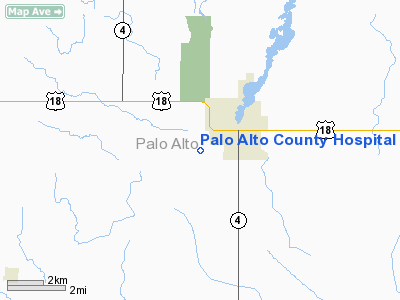
Palo Alto County Hospital Heliport |
Location &
QuickFacts
|
FAA
Information Effective: |
2007-07-05 |
|
Airport
Identifier: |
IA79 |
|
Airport
Status: |
Operational |
|
Longitude/Latitude: |
094-42-16.9300W/43-06-06.8700N
-94.704703/43.101908 (Estimated) |
|
Elevation: |
1210 ft / 368.81 m () |
|
Land: |
0 acres |
|
From
nearest city: |
0 nautical miles N of Emmetsburg, IA |
|
Location: |
Palo Alto County, IA |
|
Magnetic Variation: |
03E (2000) |
Owner & Manager
|
Ownership: |
Privately owned |
|
Owner: |
Palo Alto County Hospital |
|
Address: |
3201 1st Street
Emmetsburg, IA 50536 |
|
Manager: |
Darrell Vondrak |
|
Address: |
3201 1st Street
Emmetsburg, IA 50536 |
|
Phone number: |
712-852-5500 |
Airport
Operations and Facilities
|
Airport
Use: |
Private |
|
Segmented Circle: |
No |
|
Control
Tower: |
No |
|
Sectional chart: |
Omaha |
|
Region: |
ACE - Central |
|
Boundary
ARTCC: |
ZMP - Minneapolis |
|
Tie-in
FSS: |
FOD - Fort Dodge |
|
FSS
Phone: |
515-955-8114 |
|
FSS Toll
Free: |
1-800-WX-BRIEF |
|
Runway Information
Helipad H1
|
Dimension: |
60 x 60 ft / 18.3 x 18.3 m |
|
Surface: |
CONC, |
|
|
Runway H1
|
Runway
|
|
Traffic
Pattern: |
Left |
Left |
|
Radio Navigation Aids
|
ID |
Type |
Name |
Ch |
Freq |
Var |
Dist |
|
EGQ |
NDB |
Emmetsburg |
|
410.00 |
04E |
0.1 nm |
|
PUF |
NDB |
Puff |
|
345.00 |
04E |
15.1 nm |
|
LTU |
NDB |
Little Sioux |
|
326.00 |
05E |
18.8 nm |
|
AXA |
NDB |
Algona |
|
403.00 |
03E |
19.0 nm |
|
POH |
NDB |
Pocahontas |
|
428.00 |
06E |
21.5 nm |
|
MJQ |
NDB |
Jackson |
|
353.00 |
04E |
35.0 nm |
|
SLB |
NDB |
Storm Lake |
|
434.00 |
04E |
38.4 nm |
|
SBU |
NDB |
Blue Earth |
|
332.00 |
04E |
39.9 nm |
|
EAG |
NDB |
Eagle Grove |
|
302.00 |
03E |
42.2 nm |
|
CKP |
NDB |
Pilot Rock |
|
423.00 |
05E |
43.5 nm |
|
SKI |
NDB |
Sac City |
|
356.00 |
04E |
45.1 nm |
|
CAV |
NDB |
Clarion |
|
387.00 |
03E |
46.8 nm |
|
FXY |
NDB |
Forest City |
|
359.00 |
05E |
48.2 nm |
|
ISB |
NDB |
Sibley |
|
269.00 |
05E |
48.6 nm |
|
SHL |
NDB |
Sheldon |
|
338.00 |
05E |
50.0 nm |
|
EST |
VOR |
Estherville |
|
110.40 |
07E |
18.6 nm |
|
SPW |
VOR/DME |
Spencer |
037X |
110.00 |
05E |
22.1 nm |
|
FRM |
VOR/DME |
Fairmont |
039X |
110.20 |
07E |
34.9 nm |
|
DDL |
VOR/DME |
Sheldon |
023X |
108.60 |
05E |
50.0 nm |
|
FOD |
VORTAC |
Fort Dodge |
082X |
113.50 |
07E |
34.6 nm |
Remarks
-
PRVDD CLEAR OF
OBSTRUCTIONS; TREES LOCATED ' NW' TO 'N' AND TREE 'E' OF PAD REMOVED AND BLDGS
'SE, 'S' & 'SW' OF PAD LGTD; CONTROL PUBIC ACCESS; AND ADEQUACY FIRE
EQUIPMENT.
Palo Alto County Hospital Heliport
Address:
Palo Alto County, IA
Tel:
712-852-5500
Images
and information placed above are from
http://www.airport-data.com/airport/IA79/
We
thank them for the data!
|
General Info |
| Country |
United
States |
| State |
IOWA
|
| FAA ID |
IA79
|
| Latitude |
43-06-06.870N |
|
Longitude |
094-42-16.930W |
|
Elevation |
1210
feet |
| Near
City |
EMMETSBURG |
We don't guarantee the information is fresh and accurate. The data may
be wrong or outdated.
For more up-to-date information please refer to other sources.
|
|


