 |
|
|
|
|
|
Location &
QuickFacts
|
FAA
Information Effective: |
2007-07-05 |
|
Airport
Identifier: |
OOA |
|
Airport
Status: |
Operational |
|
Longitude/Latitude: |
092-29-37.9780W/41-13-34.1380N
-92.493883/41.226149 (Estimated) |
|
Elevation: |
840 ft / 256.03 m (Surveyed) |
|
Land: |
620 acres |
|
From
nearest city: |
9 nautical miles SE of Oskaloosa, IA |
|
Location: |
Mahaska County, IA |
|
Magnetic Variation: |
03E (1985) |
Owner & Manager
|
Ownership: |
Publicly owned |
|
Owner: |
City Of Oskaloosa |
|
Address: |
220 South Market
Oskaloosa, IA 52577 |
|
Phone number: |
641-673-9431 |
|
Manager: |
John Berens |
|
Address: |
2973 Urbana Avenue
Oskaloosa, IA 52577 |
|
Phone number: |
641-933-4316 |
Airport
Operations and Facilities
|
Airport
Use: |
Open to public |
|
Wind
indicator: |
Yes |
|
Segmented Circle: |
No |
|
Control
Tower: |
No |
|
Lighting
Schedule: |
DUSK-DAWN
ACTVT MIRL RY 13/31; REIL RYS 13 & 31 - CTAF. |
|
Beacon
Color: |
Clear-Green (lighted land airport) |
|
Landing
fee charge: |
No |
|
Sectional chart: |
Chicago |
|
Region: |
ACE - Central |
|
Boundary
ARTCC: |
ZAU - Chicago |
|
Tie-in
FSS: |
FOD - Fort Dodge |
|
FSS on
Airport: |
No |
|
FSS
Phone: |
515-955-8114 |
|
FSS Toll
Free: |
1-800-WX-BRIEF |
|
NOTAMs
Facility: |
OOA (NOTAM-d service avaliable) |
|
Federal Agreements: |
NGPY |
Airport Communications
|
CTAF: |
122.800 |
|
Unicom: |
122.800 |
Airport Services
|
Fuel
available: |
A |
|
Airframe
Repair: |
MAJOR |
|
Power
Plant Repair: |
MAJOR |
|
Bottled
Oxygen: |
HIGH |
|
Bulk
Oxygen: |
NONE |
|
Runway Information
Runway 04/22
|
Dimension: |
1925 x 75 ft / 586.7 x 22.9 m |
|
Surface: |
CONC, Fair Condition
PAVEMENT SPALLING AND JOINTS ARE UNEVEN. |
|
Weight Limit: |
Single wheel: 25000 lbs. |
|
|
Runway 04
|
Runway 22
|
|
Longitude: |
092-29-47.1100W |
092-29-29.4200W |
|
Latitude: |
41-13-36.4600N |
41-13-50.0200N |
|
Elevation: |
837.00 ft |
840.00 ft |
|
Alignment: |
45 |
127 |
|
Traffic
Pattern: |
Left |
Left |
|
Markings: |
Non-precision instrument, Fair Condition |
Non-precision instrument, Fair Condition |
|
Runway 13/31
|
Dimension: |
4003 x 75 ft / 1220.1 x 22.9 m |
|
Surface: |
CONC, Good Condition
PAVEMENT SPALLING AND JOINTS ARE UNEVEN. |
|
Weight Limit: |
Single wheel: 25000 lbs. |
|
Edge Lights: |
Medium |
|
|
Runway 13
|
Runway 31
|
|
Longitude: |
092-29-56.4400W |
092-29-19.1100W |
|
Latitude: |
41-13-43.4000N |
41-13-15.6500N |
|
Elevation: |
837.00 ft |
835.00 ft |
|
Alignment: |
127 |
127 |
|
Traffic
Pattern: |
Left |
Left |
|
Markings: |
Non-precision instrument, Good Condition |
Non-precision instrument, Good Condition |
|
VASI: |
2-light PAPI on left side |
2-light PAPI on left side |
|
Runway End
Identifier: |
Yes |
Yes |
|
Radio Navigation Aids
|
ID |
Type |
Name |
Ch |
Freq |
Var |
Dist |
|
OOA |
NDB |
Oskaloosa |
|
414.00 |
03E |
0.3 nm |
|
PEA |
NDB |
Pella |
|
257.00 |
02E |
23.0 nm |
|
FFL |
NDB |
Fairfield |
|
332.00 |
03E |
26.3 nm |
|
OXV |
NDB |
Knoxville |
|
284.00 |
03E |
28.3 nm |
|
BEX |
NDB |
Bloomfield |
|
269.00 |
02E |
29.1 nm |
|
GGI |
NDB |
Grinnell |
|
248.00 |
02E |
30.9 nm |
|
AWG |
NDB |
Washington |
|
219.00 |
02E |
37.3 nm |
|
TVK |
NDB |
Centerville |
|
290.00 |
04E |
37.3 nm |
|
TZT |
NDB |
Belle Plaine |
|
371.00 |
02E |
40.8 nm |
|
CNC |
NDB |
Chariton |
|
335.00 |
05E |
41.3 nm |
|
MPZ |
NDB |
Mount Pleasant |
|
212.00 |
02E |
47.7 nm |
|
OTM |
VOR/DME |
Ottumwa |
053X |
111.60 |
06E |
14.1 nm |
|
TNU |
VOR/DME |
Newton |
072X |
112.50 |
03E |
43.5 nm |
|
IOW |
VORTAC |
Iowa City |
109X |
116.20 |
05E |
43.4 nm |
Remarks
-
RADIO CTL MODEL
ACFT INVOF ARPT.
Based
Aircraft
|
Aircraft based
on field: |
37 |
|
Single Engine
Airplanes: |
29 |
|
Multi Engine
Airplanes: |
7 |
|
Jet Engine
Airplanes: |
1 |
Operational Statistics
Time Period: 2004-11-15 - 2005-11-14
|
Aircraft
Operations: |
149/Week |
|
Air Taxi: |
6.5% |
|
General
Aviation Local: |
51.8% |
|
General
Aviation Itinerant: |
41.7% |
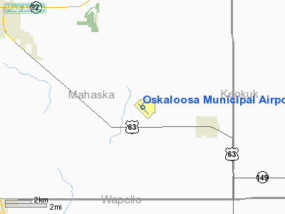
Oskaloosa Municipal Airport
Address:
Mahaska County, IA
Tel:
641-673-9431, 641-933-4316
Images
and information placed above are from
http://www.airport-data.com/airport/OOA/
We
thank them for the data!
|
General Info |
| Country |
United
States |
| State |
IOWA
|
| FAA ID |
OOA
|
| Latitude |
41-13-34.138N |
|
Longitude |
092-29-37.978W |
|
Elevation |
840 feet
|
| Near
City |
OSKALOOSA |
We don't guarantee the information is fresh and accurate. The data may
be wrong or outdated.
For more up-to-date information please refer to other sources.
|
|


