 |
|
Oelwein Municipal Airport |
|
|
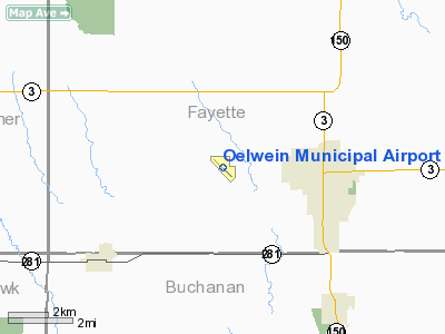
Location &
QuickFacts
|
FAA
Information Effective: |
2007-07-05 |
|
Airport
Identifier: |
OLZ |
|
Airport
Status: |
Operational |
|
Longitude/Latitude: |
091-58-28.1220W/42-40-51.0410N
-91.974478/42.680845 (Estimated) |
|
Elevation: |
1076 ft / 327.96 m (Surveyed) |
|
Land: |
300 acres |
|
From
nearest city: |
3 nautical miles W of Oelwein, IA |
|
Location: |
Fayette County, IA |
|
Magnetic Variation: |
02E (1985) |
Owner & Manager
|
Ownership: |
Publicly owned |
|
Owner: |
City Of Oelwein |
|
Address: |
20 2nd Ave Sw
Oelwein, IA 50662 |
|
Phone number: |
563-283-5440 |
|
Manager: |
Steven Kendall |
|
Address: |
19623 40th St
Oelwein, IA 50662 |
|
Phone number: |
563-283-5440 |
Airport
Operations and Facilities
|
Airport
Use: |
Open to public |
|
Wind
indicator: |
Yes |
|
Segmented Circle: |
No |
|
Control
Tower: |
No |
|
Lighting
Schedule: |
DUSK-DAWN
ACTVT MIRL RY 13/31 & REIL RY 13 - CTAF. |
|
Beacon
Color: |
Clear-Green (lighted land airport) |
|
Landing
fee charge: |
No |
|
Sectional chart: |
Chicago |
|
Region: |
ACE - Central |
|
Boundary
ARTCC: |
ZAU - Chicago |
|
Tie-in
FSS: |
FOD - Fort Dodge |
|
FSS on
Airport: |
No |
|
FSS
Phone: |
515-955-8114 |
|
FSS Toll
Free: |
1-800-WX-BRIEF |
|
NOTAMs
Facility: |
OLZ (NOTAM-d service avaliable) |
|
Federal Agreements: |
NGY |
Airport Communications
|
CTAF: |
122.800 |
|
Unicom: |
122.800 |
Airport Services
|
Fuel
available: |
100LLA |
|
Airframe
Repair: |
MAJOR |
|
Power
Plant Repair: |
MAJOR |
|
Bottled
Oxygen: |
NONE |
|
Bulk
Oxygen: |
NONE |
|
Runway Information
Runway 13/31
|
Dimension: |
4001 x 75 ft / 1219.5 x 22.9 m |
|
Surface: |
CONC, Good Condition |
|
Surface
Treatment: |
Wire Comb or Wire Tine |
|
Weight Limit: |
Single wheel: 12000 lbs. |
|
Edge Lights: |
Medium |
|
|
Runway 13
|
Runway 31
|
|
Longitude: |
091-58-48.1156W |
091-58-09.9250W |
|
Latitude: |
42-41-02.8593N |
42-40-35.1527N |
|
Elevation: |
1076.00 ft |
1059.00 ft |
|
Alignment: |
127 |
127 |
|
Traffic
Pattern: |
Left |
Left |
|
Markings: |
Non-precision instrument, Good Condition |
Non-precision instrument, Good Condition |
|
Runway End
Identifier: |
Yes |
|
|
Obstruction: |
17 ft road, 480.0 ft from runway, 290 ft right of
centerline, 16:1 slope to clear |
, 50:1 slope to clear |
|
Runway 18/36
|
Dimension: |
1800 x 85 ft / 548.6 x 25.9 m |
|
Surface: |
TURF, Fair Condition |
|
|
Runway 18
|
Runway 36
|
|
Longitude: |
091-58-25.6220W |
091-58-26.6220W |
|
Latitude: |
42-41-03.9410N |
42-40-46.9410N |
|
Alignment: |
127 |
2 |
|
Traffic
Pattern: |
Left |
Left |
|
Obstruction: |
10 ft road, 390.0 ft from runway, 39:1 slope to clear |
, 50:1 slope to clear |
|
Radio Navigation Aids
|
ID |
Type |
Name |
Ch |
Freq |
Var |
Dist |
|
OLZ |
NDB |
Oelwein |
|
260.00 |
02E |
0.2 nm |
|
IIB |
NDB |
Wapsie |
|
206.00 |
02E |
13.8 nm |
|
XWY |
NDB |
West Union |
|
278.00 |
02E |
17.9 nm |
|
VTI |
NDB |
Garrison |
|
338.00 |
03E |
27.7 nm |
|
CCY |
NDB |
Charles City |
|
375.00 |
03E |
36.4 nm |
|
DEH |
NDB |
Decorah |
|
236.00 |
01E |
37.3 nm |
|
CJJ |
NDB |
Cresco |
|
293.00 |
02E |
41.8 nm |
|
IY |
NDB |
Chukk |
|
417.00 |
03E |
42.9 nm |
|
MXO |
NDB |
Monticello |
|
397.00 |
01E |
47.0 nm |
|
TZT |
NDB |
Belle Plaine |
|
371.00 |
02E |
49.7 nm |
|
CID |
VOR/DME |
Cedar Rapids |
088X |
114.10 |
05E |
48.4 nm |
|
ALO |
VORTAC |
Waterloo |
059X |
112.20 |
06E |
20.2 nm |
|
UKN |
VORTAC |
Waukon |
113X |
116.60 |
05E |
40.8 nm |
Remarks
-
RY 18/36 CLSD
AFTER FIRST SNOWFALL.
Based
Aircraft
|
Aircraft based
on field: |
14 |
|
Single Engine
Airplanes: |
13 |
|
Ultralights: |
1 |
Operational Statistics
Time Period:
2003-06-23 -
2004-06-21
|
Aircraft
Operations: |
83/Week |
|
General
Aviation Local: |
44.0% |
|
General
Aviation Itinerant: |
56.0% |
Oelwein Municipal Airport
Address:
Fayette County, IA
Tel:
563-283-5440
Images
and information placed above are from
http://www.airport-data.com/airport/OLZ/
We
thank them for the data!
|
General Info |
| Country |
United
States |
| State |
IOWA
|
| FAA ID |
OLZ
|
| Latitude |
42-40-51.041N |
|
Longitude |
091-58-28.122W |
|
Elevation |
1076
feet |
| Near
City |
OELWEIN
|
We don't guarantee the information is fresh and accurate. The data may
be wrong or outdated.
For more up-to-date information please refer to other sources.
|
|


