 |
|
| Newton Municipal Airport |
| IATA: TNU â ICAO: KTNU â FAA LID: TNU |
| Summary |
| Airport type |
Public |
| Owner |
City of Newton |
| Serves |
Newton, Iowa |
| Elevation AMSL |
953 ft / 290 m |
| Coordinates |
41°40â²28â³N 093°01â²18â³W / 41.67444°N 93.02167°W / 41.67444; -93.02167 |
| Runways |
| Direction |
Length |
Surface |
| ft |
m |
| 14/32 |
5,599 |
1,707 |
Asphalt |
| Statistics (2007) |
| Aircraft operations |
9,000 |
| Based aircraft |
21 |
| Source: Federal Aviation Administration |
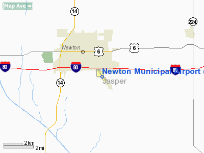
Newton Municipal Airport (IATA: TNU, ICAO: KTNU, FAA LID: TNU) is a city-owned public-use airport located two miles (3 km) southeast of the central business district of Newton, a city in Jasper County, Iowa, United States.
Facilities and aircraft
Newton Municipal Airport covers an area of 304 acres (123 ha) which contains one runway designated 14/32 with a 5,599 x 100 ft (1,707 x 30 m) asphalt surface. For the 12-month period ending September 12, 2007, the airport had 9,000 aircraft operations, an average of 24 per day: 93% general aviation and 7% air taxi. At that time there were 21 aircraft based at this airport: 90% single-engine and 10% multi-engine.
The above content comes from Wikipedia and is published under free licenses – click here to read more.
Location &
QuickFacts
|
FAA
Information Effective: |
2007-07-05 |
|
Airport
Identifier: |
TNU |
|
Airport
Status: |
Operational |
|
Longitude/Latitude: |
093-01-18.2250W/41-40-27.9470N
-93.021729/41.674430 (Estimated) |
|
Elevation: |
953 ft / 290.47 m (Estimated) |
|
Land: |
304 acres |
|
From
nearest city: |
2 nautical miles SE of Newton, IA |
|
Location: |
Jasper County, IA |
|
Magnetic Variation: |
03E (1995) |
Owner & Manager
|
Ownership: |
Publicly owned |
|
Owner: |
City Of Newton |
|
Address: |
115 N. 2nd Ave E. Po Box 399
Newton, IA 50208 |
|
Phone
number: |
641-792-2787 |
|
Manager: |
Ethan Nasalroad |
|
Address: |
Box 986-2901 Rusty Wallace Drive
Newton, IA 50208 |
|
Phone number: |
641-792-1292 |
Airport Operations and Facilities
|
Airport
Use: |
Open to public |
|
Wind
indicator: |
Yes |
|
Segmented Circle: |
No |
|
Control
Tower: |
No |
|
Lighting
Schedule: |
DUSK-DAWN
MIRL RY 14/32 PRESET LOW INTST; TO INCR INTST & ACTVT VASI RYS 14 &
32; REIL RY 14 AND MALSR RY 32 - CTAF. |
|
Beacon
Color: |
Clear-Green (lighted land airport) |
|
Landing
fee charge: |
No |
|
Sectional chart: |
Omaha |
|
Region: |
ACE - Central |
|
Boundary
ARTCC: |
ZAU - Chicago |
|
Responsible ARTCC: |
ZMP - Minneapolis |
|
Tie-in
FSS: |
FOD - Fort Dodge |
|
FSS on
Airport: |
No |
|
FSS
Phone: |
515-955-8114 |
|
FSS Toll
Free: |
1-800-WX-BRIEF |
|
NOTAMs
Facility: |
TNU (NOTAM-d service avaliable) |
|
Federal Agreements: |
NGY |
Airport Communications
|
CTAF: |
122.800 |
|
Unicom: |
122.800 |
Airport Services
|
Fuel
available: |
100LLA |
|
Airframe
Repair: |
MAJOR |
|
Power
Plant Repair: |
MAJOR |
|
Bottled
Oxygen: |
NONE |
|
Bulk
Oxygen: |
NONE |
|
Runway Information
Runway 14/32
|
Dimension: |
5599 x 100 ft / 1706.6 x 30.5 m |
|
Surface: |
ASPH, Good Condition |
|
Weight Limit: |
Single wheel: 22000 lbs.
Dual wheel: 30000 lbs. |
|
Edge Lights: |
Medium |
|
|
Runway 14
|
Runway 32
|
|
Longitude: |
093-01-41.3330W |
093-00-55.1220W |
|
Latitude: |
41-40-49.5070N |
41-40-06.3860N |
|
Elevation: |
952.00 ft |
946.00 ft |
|
Alignment: |
127 |
127 |
|
ILS Type: |
|
ILS |
|
Traffic
Pattern: |
Left |
Left |
|
Markings: |
Precision instrument, Fair Condition |
Precision instrument, Fair Condition |
|
Crossing
Height: |
39.00 ft |
40.00 ft |
|
VASI: |
4-box on left side |
4-box on left side
VASI UNUSBL BYD 9 DEGS LEFT OF COURSE. |
|
Visual
Glide Angle: |
3.00° |
3.00° |
|
Approach
lights: |
|
MALSR |
|
Runway End
Identifier: |
Yes |
|
|
Obstruction: |
18 ft road, 860.0 ft from runway, 350 ft left of
centerline, 36:1 slope to clear |
, 50:1 slope to clear |
|
Radio Navigation Aids
|
ID |
Type |
Name |
Ch |
Freq |
Var |
Dist |
|
GGI |
NDB |
Grinnell |
|
248.00 |
02E |
13.3 nm |
|
PEA |
NDB |
Pella |
|
257.00 |
02E |
16.6 nm |
|
OXV |
NDB |
Knoxville |
|
284.00 |
03E |
23.1 nm |
|
IKV |
NDB |
Ankeny |
|
275.00 |
03E |
24.4 nm |
|
MIW |
NDB |
Marshalltown |
|
239.00 |
03E |
26.6 nm |
|
TZT |
NDB |
Belle Plaine |
|
371.00 |
02E |
35.5 nm |
|
OOA |
NDB |
Oskaloosa |
|
414.00 |
03E |
36.2 nm |
|
CNC |
NDB |
Chariton |
|
335.00 |
05E |
42.4 nm |
|
BNW |
NDB |
Boone |
|
407.00 |
03E |
43.7 nm |
|
IFA |
NDB |
Iowa Falls |
|
368.00 |
03E |
49.4 nm |
|
TNU |
VOR/DME |
Newton |
072X |
112.50 |
03E |
7.7 nm |
|
JWJ |
VOR/DME |
Elmwood |
031X |
109.40 |
03E |
26.7 nm |
|
OTM |
VOR/DME |
Ottumwa |
053X |
111.60 |
06E |
49.9 nm |
|
DSM |
VORTAC |
Des Moines |
122X |
117.50 |
07E |
31.6 nm |
|
DSM |
VOT |
Des Moines |
|
109.20 |
|
30.4 nm |
Remarks
Based
Aircraft
|
Aircraft based
on field: |
23 |
|
Single Engine
Airplanes: |
19 |
|
Multi Engine
Airplanes: |
2 |
|
Jet Engine
Airplanes: |
2 |
Operational Statistics
Time Period:
2003-12-05 -
2004-12-03
|
Aircraft
Operations: |
259/Week |
|
Air Taxi: |
7.4% |
|
General
Aviation Local: |
54.4% |
|
General
Aviation Itinerant: |
38.2% |
Newton Municipal Airport
Address:
Jasper County, IA
Tel:
641-792-2787,
641-792-1292
Images
and information placed above are from
http://www.airport-data.com/airport/TNU/
We
thank them for the data!
|
General Info |
| Country |
United
States |
| State |
IOWA
|
| FAA ID |
TNU
|
| Latitude |
41-40-27.947N |
|
Longitude |
093-01-18.225W |
|
Elevation |
953 feet
|
| Near
City |
NEWTON
|
We don't guarantee the information is fresh and accurate. The data may
be wrong or outdated.
For more up-to-date information please refer to other sources.
|
|


