 |
|
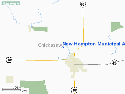
New Hampton Municipal Airport |
|
|
Location &
QuickFacts
|
FAA
Information Effective: |
2007-07-05 |
|
Airport
Identifier: |
1Y5 |
|
Airport
Status: |
Operational |
|
Longitude/Latitude: |
092-20-35.6370W/43-05-13.9050N
-92.343232/43.087196 (Estimated) |
|
Elevation: |
1173 ft / 357.53 m (Surveyed) |
|
Land: |
197 acres |
|
From
nearest city: |
2 nautical miles NW of New Hampton, IA |
|
Location: |
Chickasaw County, IA |
|
Magnetic Variation: |
03E (1985) |
Owner & Manager
|
Ownership: |
Publicly owned |
|
Owner: |
City Of New Hampton |
|
Address: |
112 East Spring
New Hampton, IA 50659 |
|
Phone
number: |
641-394-5906 |
|
Manager: |
Richard Grote
ARPT COMM. |
|
Address: |
515 Garfield Street
New Hampton, IA 50659 |
|
Phone number: |
641-394-3188 |
Airport Operations and Facilities
|
Airport
Use: |
Open to public |
|
Wind
indicator: |
Yes |
|
Segmented Circle: |
No |
|
Control
Tower: |
No |
|
Lighting
Schedule: |
DUSK-DAWN |
|
Beacon
Color: |
Clear-Green (lighted land airport) |
|
Landing
fee charge: |
No |
|
Sectional chart: |
Chicago |
|
Region: |
ACE - Central |
|
Boundary
ARTCC: |
ZMP - Minneapolis |
|
Responsible ARTCC: |
ZAU - Chicago |
|
Tie-in
FSS: |
FOD - Fort Dodge |
|
FSS on
Airport: |
No |
|
FSS
Phone: |
515-955-8114 |
|
FSS Toll
Free: |
1-800-WX-BRIEF |
|
NOTAMs
Facility: |
FOD (NOTAM-d service avaliable) |
|
Federal Agreements: |
Y1 |
Airport Communications
Airport Services
|
Airframe
Repair: |
NONE |
|
Power
Plant Repair: |
NONE |
|
Bottled
Oxygen: |
NONE |
|
Bulk
Oxygen: |
NONE |
|
Runway Information
Runway 04/22
|
Dimension: |
2300 x 105 ft / 701.0 x 32.0 m |
|
Surface: |
TURF, Fair Condition |
|
|
Runway 04
|
Runway 22
|
|
Traffic
Pattern: |
Left |
Left |
|
Obstruction: |
20 ft pole, 520.0 ft from runway, 20 ft right of
centerline, 26:1 slope to clear |
15 ft road, 550.0 ft from runway, 36:1 slope to clear |
|
Runway 17/35
|
Dimension: |
2900 x 75 ft / 883.9 x 22.9 m |
|
Surface: |
ASPH, Fair Condition |
|
Weight Limit: |
Single wheel: 16000 lbs. |
|
Edge Lights: |
Low |
|
|
Runway 17
|
Runway 35
|
|
Elevation: |
1173.00 ft |
1167.00 ft |
|
Traffic
Pattern: |
Left |
Left |
|
Markings: |
Basic, Good Condition |
Basic, Good Condition |
|
Obstruction: |
25 ft tree, 685.0 ft from runway, 165 ft right of
centerline, 19:1 slope to clear |
10 ft road, 500.0 ft from runway, 30:1 slope to clear |
|
Radio Navigation Aids
|
ID |
Type |
Name |
Ch |
Freq |
Var |
Dist |
|
CCY |
NDB |
Charles City |
|
375.00 |
03E |
11.7 nm |
|
IY |
NDB |
Chukk |
|
417.00 |
03E |
17.1 nm |
|
CJJ |
NDB |
Cresco |
|
293.00 |
02E |
19.2 nm |
|
XWY |
NDB |
West Union |
|
278.00 |
02E |
26.1 nm |
|
DEH |
NDB |
Decorah |
|
236.00 |
01E |
28.9 nm |
|
OLZ |
NDB |
Oelwein |
|
260.00 |
02E |
29.1 nm |
|
IIB |
NDB |
Wapsie |
|
206.00 |
02E |
41.9 nm |
|
HPT |
NDB |
Hampton |
|
230.00 |
03E |
44.5 nm |
|
CHU |
NDB |
Caledonia |
|
209.00 |
03E |
47.9 nm |
|
JAY |
VOR/DME |
Austin |
019X |
108.20 |
03E |
38.7 nm |
|
RST |
VOR/DME |
Rochester |
057X |
112.00 |
05E |
43.3 nm |
|
ALO |
VORTAC |
Waterloo |
059X |
112.20 |
06E |
32.0 nm |
|
UKN |
VORTAC |
Waukon |
113X |
116.60 |
05E |
37.2 nm |
|
MCW |
VORTAC |
Mason City |
096X |
114.90 |
06E |
43.3 nm |
Remarks
-
RC ACFT OPNS IN
AREA.
-
RY 17 IS CALM
WIND RY.
Operational
Statistics
Time Period:
2003-01-07 -
2004-01-06
|
Aircraft
Operations: |
49/Week |
|
General
Aviation Local: |
70.0% |
|
General
Aviation Itinerant: |
30.0% |
New Hampton Municipal Airport
Address:
Chickasaw County, IA
Tel:
641-394-5906,
641-394-3188
Images
and information placed above are from
http://www.airport-data.com/airport/1Y5/
We
thank them for the data!
|
General Info |
| Country |
United
States |
| State |
IOWA
|
| FAA ID |
1Y5
|
| Latitude |
43-05-13.905N |
|
Longitude |
092-20-35.637W |
|
Elevation |
1173
feet |
| Near
City |
NEW
HAMPTON |
We don't guarantee the information is fresh and accurate. The data may
be wrong or outdated.
For more up-to-date information please refer to other sources.
|
|


