 |
|
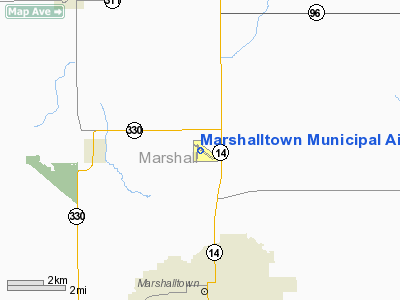
Marshalltown Municipal Airport |
|
|
Location &
QuickFacts
|
FAA
Information Effective: |
2007-07-05 |
|
Airport
Identifier: |
MIW |
|
Airport
Status: |
Operational |
|
Longitude/Latitude: |
092-55-04.0360W/42-06-45.8150N
-92.917788/42.112726 (Estimated) |
|
Elevation: |
974 ft / 296.88 m (Surveyed) |
|
Land: |
259 acres |
|
From
nearest city: |
3 nautical miles N of Marshalltown, IA |
|
Location: |
Marshall County, IA |
|
Magnetic Variation: |
03E (1995) |
Owner & Manager
|
Ownership: |
Publicly owned |
|
Owner: |
City Of Marshalltown |
|
Address: |
Po Box 757
Marshalltown, IA 50158 |
|
Phone number: |
641-754-0012 |
|
Manager: |
William Smothers
BILL |
|
Address: |
2651 170th St
Marshalltown, IA 50158 |
|
Phone number: |
641-752-0012 |
Airport
Operations and Facilities
|
Airport
Use: |
Open to public |
|
Wind
indicator: |
Yes |
|
Segmented Circle: |
No |
|
Control
Tower: |
No |
|
Lighting
Schedule: |
DUSK-DAWN
MIRL RY 12/30 PRESET ON LOW INTST; TO INCR INTST & ACTVT REIL & VASI
RY 12 & 30 - CTAF.
MIRL RY
18/36 OPRS DUSK-DAWN. |
|
Beacon
Color: |
Clear-Green (lighted land airport) |
|
Landing
fee charge: |
No |
|
Sectional chart: |
Chicago |
|
Region: |
ACE - Central |
|
Boundary
ARTCC: |
ZAU - Chicago |
|
Tie-in
FSS: |
FOD - Fort Dodge |
|
FSS on
Airport: |
No |
|
FSS
Phone: |
515-955-8114 |
|
FSS Toll
Free: |
1-800-WX-BRIEF |
|
NOTAMs
Facility: |
MIW (NOTAM-d service avaliable) |
|
Federal Agreements: |
NGY |
Airport Communications
|
CTAF: |
122.800 |
|
Unicom: |
122.800 |
Airport Services
|
Fuel
available: |
100LLA |
|
Airframe
Repair: |
MAJOR |
|
Power
Plant Repair: |
MAJOR |
|
Bottled
Oxygen: |
LOW |
|
Runway Information
Runway 12/30
|
Dimension: |
5006 x 100 ft / 1525.8 x 30.5 m |
|
Surface: |
ASPH, Good Condition |
|
Weight Limit: |
Single wheel: 35000 lbs.
Dual wheel: 42000 lbs. |
|
Edge Lights: |
Medium |
|
|
Runway 12
|
Runway 30
|
|
Longitude: |
092-55-26.4780W |
092-54-33.4850W |
|
Latitude: |
42-07-01.2470N |
42-06-31.4380N |
|
Elevation: |
974.00 ft |
971.00 ft |
|
Alignment: |
127 |
127 |
|
Traffic
Pattern: |
Left |
Left |
|
Markings: |
Non-precision instrument, Good Condition |
Non-precision instrument, Good Condition |
|
Crossing
Height: |
42.00 ft |
37.00 ft |
|
VASI: |
4-box on left side |
4-box on left side |
|
Visual
Glide Angle: |
3.00° |
3.00° |
|
Runway End
Identifier: |
Yes |
Yes |
|
Obstruction: |
8 ft gnd, 411.0 ft from runway, 26:1 slope to clear |
19 ft road, 570.0 ft from runway, 305 ft left of
centerline, 19:1 slope to clear |
|
Runway 18/36
|
Dimension: |
2806 x 50 ft / 855.3 x 15.2 m |
|
Surface: |
ASPH, Good Condition |
|
Weight Limit: |
Single wheel: 15000 lbs. |
|
Edge Lights: |
Medium |
|
|
Runway 18
|
Runway 36
|
|
Longitude: |
092-55-10.1130W |
092-55-12.4320W |
|
Latitude: |
42-06-58.7070N |
42-06-31.0390N |
|
Elevation: |
971.00 ft |
968.00 ft |
|
Alignment: |
127 |
4 |
|
Traffic
Pattern: |
Left |
Left |
|
Markings: |
Basic, Fair Condition |
Basic, Fair Condition |
|
Obstruction: |
16 ft trees, 630.0 ft from runway, 180 ft right of
centerline, 26:1 slope to clear |
20 ft road, 545.0 ft from runway, 17:1 slope to clear |
|
Radio Navigation Aids
|
ID |
Type |
Name |
Ch |
Freq |
Var |
Dist |
|
MIW |
NDB |
Marshalltown |
|
239.00 |
03E |
0.2 nm |
|
GGI |
NDB |
Grinnell |
|
248.00 |
02E |
25.6 nm |
|
IFA |
NDB |
Iowa Falls |
|
368.00 |
03E |
26.8 nm |
|
TZT |
NDB |
Belle Plaine |
|
371.00 |
02E |
31.5 nm |
|
IKV |
NDB |
Ankeny |
|
275.00 |
03E |
38.1 nm |
|
HPT |
NDB |
Hampton |
|
230.00 |
03E |
39.3 nm |
|
VTI |
NDB |
Garrison |
|
338.00 |
03E |
40.5 nm |
|
BNW |
NDB |
Boone |
|
407.00 |
03E |
41.9 nm |
|
PEA |
NDB |
Pella |
|
257.00 |
02E |
42.5 nm |
|
EBS |
NDB |
Webster City |
|
323.00 |
03E |
46.7 nm |
|
IIB |
NDB |
Wapsie |
|
206.00 |
02E |
47.6 nm |
|
OXV |
NDB |
Knoxville |
|
284.00 |
03E |
49.9 nm |
|
JWJ |
VOR/DME |
Elmwood |
031X |
109.40 |
03E |
0.4 nm |
|
TNU |
VOR/DME |
Newton |
072X |
112.50 |
03E |
21.5 nm |
|
ALO |
VORTAC |
Waterloo |
059X |
112.20 |
06E |
35.3 nm |
|
DSM |
VOT |
Des Moines |
|
109.20 |
|
48.3 nm |
Based Aircraft
|
Aircraft based
on field: |
36 |
|
Single Engine
Airplanes: |
30 |
|
Multi Engine
Airplanes: |
6 |
Operational Statistics
Time Period:
2005-06-27 -
2006-06-26
|
Aircraft
Operations: |
52/Day |
|
Air Taxi: |
5.9% |
|
General
Aviation Local: |
40.6% |
|
General
Aviation Itinerant: |
53.5% |
Marshalltown Municipal Airport
Address:
Marshall County, IA
Tel:
641-754-0012
Images
and information placed above are from
http://www.airport-data.com/airport/MIW/
We
thank them for the data!
|
General Info |
| Country |
United
States |
| State |
IOWA
|
| FAA ID |
MIW
|
| Latitude |
42-06-45.815N |
|
Longitude |
092-55-04.036W |
|
Elevation |
974 feet
|
| Near
City |
MARSHALLTOWN |
We don't guarantee the information is fresh and accurate. The data may
be wrong or outdated.
For more up-to-date information please refer to other sources.
|
|


