 |
|
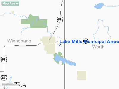
Lake Mills Municipal Airport |
|
|
Location &
QuickFacts
|
FAA
Information Effective: |
2007-07-05 |
|
Airport
Identifier: |
0Y6 |
|
Airport
Status: |
Operational |
|
Longitude/Latitude: |
093-30-30.7600W/43-24-59.8360N
-93.508544/43.416621 (Estimated) |
|
Elevation: |
1260 ft / 384.05 m (Surveyed) |
|
Land: |
40 acres |
|
From
nearest city: |
1 nautical miles E of Lake Mills, IA |
|
Location: |
Winnebago County, IA |
|
Magnetic Variation: |
04E (1985) |
Owner & Manager
|
Ownership: |
Publicly owned |
|
Owner: |
City Of Lake Mills |
|
Address: |
105 W. Main
Lake Mills, IA 50450 |
|
Phone
number: |
641-592-3251 |
|
Manager: |
Leo Russell |
|
Address: |
105 W. Main
Lake Mills, IA 50450 |
|
Phone number: |
641-592-3251 |
Airport Operations and Facilities
|
Airport
Use: |
Open to public |
|
Wind
indicator: |
Yes |
|
Segmented Circle: |
No |
|
Control
Tower: |
No |
|
Lighting
Schedule: |
DUSK-DAWN |
|
Beacon
Color: |
Clear-Green (lighted land airport) |
|
Landing
fee charge: |
No |
|
Sectional chart: |
Omaha |
|
Region: |
ACE - Central |
|
Boundary
ARTCC: |
ZMP - Minneapolis |
|
Tie-in
FSS: |
FOD - Fort Dodge |
|
FSS on
Airport: |
No |
|
FSS
Phone: |
515-955-8114 |
|
FSS Toll
Free: |
1-800-WX-BRIEF |
|
NOTAMs
Facility: |
FOD (NOTAM-d service avaliable) |
Airport Communications
Airport Services
|
Airframe
Repair: |
NONE |
|
Power
Plant Repair: |
NONE |
|
Bottled
Oxygen: |
NONE |
|
Bulk
Oxygen: |
NONE |
|
Runway Information
Runway 18/36
|
Dimension: |
3380 x 100 ft / 1030.2 x 30.5 m |
|
Surface: |
TURF, Good Condition |
|
Edge Lights: |
Low |
|
|
Runway 18
|
Runway 36
|
|
Traffic
Pattern: |
Left |
Left |
|
Displaced
threshold: |
0.00 ft |
190.00 ft |
|
Obstruction: |
49 ft tree, 1645.0 ft from runway, 200 ft right of
centerline, 33:1 slope to clear |
99 ft trees, 1700.0 ft from runway, 110 ft right of
centerline, 17:1 slope to clear
APCH RATIO 19:1 TO DSPLCD THLD. |
|
Radio Navigation Aids
|
ID |
Type |
Name |
Ch |
Freq |
Var |
Dist |
|
FXY |
NDB |
Forest City |
|
359.00 |
05E |
12.0 nm |
|
SBU |
NDB |
Blue Earth |
|
332.00 |
04E |
27.8 nm |
|
IY |
NDB |
Chukk |
|
417.00 |
03E |
38.1 nm |
|
AXA |
NDB |
Algona |
|
403.00 |
03E |
39.0 nm |
|
ACQ |
NDB |
Waseca |
|
371.00 |
02E |
39.3 nm |
|
CAV |
NDB |
Clarion |
|
387.00 |
03E |
41.8 nm |
|
HPT |
NDB |
Hampton |
|
230.00 |
03E |
43.4 nm |
|
CCY |
NDB |
Charles City |
|
375.00 |
03E |
44.6 nm |
|
EAG |
NDB |
Eagle Grove |
|
302.00 |
03E |
46.1 nm |
|
AEL |
VOR/DME |
Albert Lea |
035X |
109.80 |
05E |
17.0 nm |
|
JAY |
VOR/DME |
Austin |
019X |
108.20 |
03E |
27.4 nm |
|
FRM |
VOR/DME |
Fairmont |
039X |
110.20 |
07E |
42.1 nm |
|
RST |
VOR/DME |
Rochester |
057X |
112.00 |
05E |
45.4 nm |
|
FOW |
VOR/DME |
Halfway |
049X |
111.20 |
02E |
47.7 nm |
|
MCW |
VORTAC |
Mason City |
096X |
114.90 |
06E |
20.9 nm |
Remarks
-
ARPT CLSD DEC-MAR.
-
TELEPHONE IN
HANGAR - LOCAL CALLS ONLY.
-
PROVIDED APCH TO
EACH RWY IS MAINTAINED FOR A MIN 20:1 GLIDE SLOPE AND THE TRANSITIONAL SURFACE
BE MAINTAINED FOR A 7:1 SLOPE.
Based Aircraft
|
Aircraft based
on field: |
4 |
|
Single Engine
Airplanes: |
3 |
|
Ultralights: |
1 |
Operational Statistics
Time Period:
2005-07-27 -
2006-07-26
|
Aircraft
Operations: |
29/Week |
|
General
Aviation Local: |
43.2% |
|
General
Aviation Itinerant: |
56.8% |
Lake Mills Municipal Airport
Address:
Winnebago County, IA
Tel:
641-592-3251
Images
and information placed above are from
http://www.airport-data.com/airport/0Y6/
We
thank them for the data!
|
General Info |
| Country |
United
States |
| State |
IOWA
|
| FAA ID |
0Y6
|
| Latitude |
43-24-59.836N |
|
Longitude |
093-30-30.760W |
|
Elevation |
1260
feet |
| Near
City |
LAKE
MILLS |
We don't guarantee the information is fresh and accurate. The data may
be wrong or outdated.
For more up-to-date information please refer to other sources.
|
|


