 |
|
|
|
Location &
QuickFacts
|
FAA
Information Effective: |
2007-07-05 |
|
Airport
Identifier: |
24IA |
|
Airport
Status: |
Operational |
|
Longitude/Latitude: |
092-31-11.3200W/42-30-56.9000N
-92.519811/42.515806 (Estimated) |
|
Elevation: |
982 ft / 299.31 m (Estimated) |
|
Land: |
9 acres |
|
From
nearest city: |
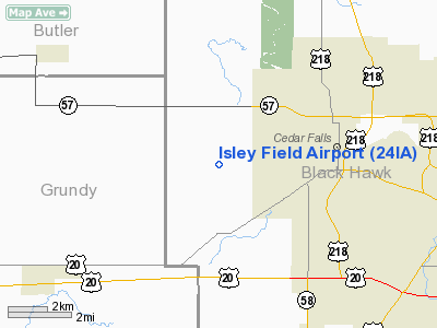
3 nautical miles W of Cedar Falls, IA |
|
Location: |
Black Hawk County, IA |
|
Magnetic Variation: |
03E (1985) |
Owner & Manager
|
Ownership: |
Privately owned |
|
Owner: |
Isley Farm, Inc. |
|
Address: |
Rt 4, 204 Jepsen Road
Cedar Falls, IA 50613 |
|
Phone
number: |
319-266-7982 |
|
Manager: |
Gaylon Isley |
|
Address: |
Rt 4, 204 Jepsen Road
Cedar Falls, IA 50613 |
|
Phone number: |
319-266-7982 |
Airport Operations and Facilities
|
Airport Use: |
Private |
|
Wind indicator: |
Yes |
|
Segmented Circle: |
No |
|
Control Tower: |
No |
|
Landing fee charge: |
No |
|
Sectional chart: |
Chicago |
|
Region: |
ACE - Central |
|
Boundary ARTCC: |
ZAU - Chicago |
|
Tie-in FSS: |
FOD - Fort Dodge |
|
FSS on Airport: |
No |
|
FSS Phone: |
515-955-8114 |
|
FSS Toll Free: |
1-800-WX-BRIEF |
Airport Services
|
Airframe
Repair: |
NONE |
|
Power
Plant Repair: |
NONE |
|
Runway Information
Runway 08/26
|
Dimension: |
2600 x 190 ft / 792.5 x 57.9 m |
|
Surface: |
TURF, |
|
|
Runway 08
|
Runway 26
|
|
Longitude: |
092-31-28.6800W |
092-30-53.9600W |
|
Latitude: |
42-30-56.9400N |
42-30-56.9400N |
|
Elevation: |
970.00 ft |
982.00 ft |
|
Traffic
Pattern: |
Left |
Left |
|
Radio Navigation Aids
|
ID |
Type |
Name |
Ch |
Freq |
Var |
Dist |
|
IIB |
NDB |
Wapsie |
|
206.00 |
02E |
25.5 nm |
|
OLZ |
NDB |
Oelwein |
|
260.00 |
02E |
26.1 nm |
|
VTI |
NDB |
Garrison |
|
338.00 |
03E |
28.4 nm |
|
MIW |
NDB |
Marshalltown |
|
239.00 |
03E |
30.1 nm |
|
IFA |
NDB |
Iowa Falls |
|
368.00 |
03E |
33.1 nm |
|
CCY |
NDB |
Charles City |
|
375.00 |
03E |
33.4 nm |
|
HPT |
NDB |
Hampton |
|
230.00 |
03E |
33.6 nm |
|
IY |
NDB |
Chukk |
|
417.00 |
03E |
38.3 nm |
|
TZT |
NDB |
Belle Plaine |
|
371.00 |
02E |
39.3 nm |
|
XWY |
NDB |
West Union |
|
278.00 |
02E |
41.5 nm |
|
GGI |
NDB |
Grinnell |
|
248.00 |
02E |
49.3 nm |
|
JWJ |
VOR/DME |
Elmwood |
031X |
109.40 |
03E |
29.8 nm |
|
CID |
VOR/DME |
Cedar Rapids |
088X |
114.10 |
05E |
49.9 nm |
|
ALO |
VORTAC |
Waterloo |
059X |
112.20 |
06E |
5.9 nm |
|
MCW |
VORTAC |
Mason City |
096X |
114.90 |
06E |
49.9 nm |
Remarks
-
ARPT NORMALLY
CLSD IN WINTER SNOW MONTHS.
-
CONDITIONAL--PROVIDED APPROACH TO EACH RWY IS MAINTAINED FOR A MINIMUM 20:1
GLIDE SLOPE & THE TRANSITIONAL SURFACE BE MAINTAINED FOR A 7-1 SLOPE.
Based
Aircraft
|
Aircraft based
on field: |
1 |
|
Single Engine
Airplanes: |
1 |
Operational Statistics
|
Aircraft
Operations: |
47/Week |
|
General
Aviation Local: |
58.3% |
|
General
Aviation Itinerant: |
41.7% |
Isley Field Airport
Address:
Black Hawk County, IA
Tel:
319-266-7982
Images
and information placed above are from
http://www.airport-data.com/airport/24IA/
We
thank them for the data!
|
General Info |
| Country |
United
States |
| State |
IOWA
|
| FAA ID |
24IA
|
| Latitude |
42-31-14.940N |
|
Longitude |
092-31-09.683W |
|
Elevation |
982 feet
|
| Near
City |
CEDAR
FALLS |
We don't guarantee the information is fresh and accurate. The data may
be wrong or outdated.
For more up-to-date information please refer to other sources.
|
|


