 |
|
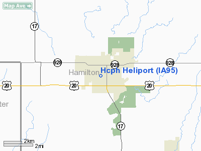
Hamilton County Public Hospital Heliport |
Location &
QuickFacts
|
FAA
Information Effective: |
2007-07-05 |
|
Airport
Identifier: |
IA95 |
|
Airport
Status: |
Operational |
|
Longitude/Latitude: |
093-49-25.7960W/42-27-31.9060N
-93.823832/42.458863 (Estimated) |
|
Elevation: |
1080 ft / 329.18 m (Estimated) |
|
Land: |
0 acres |
|
From
nearest city: |
0 nautical miles N of Webster City, IA |
|
Location: |
Hamilton County, IA |
|
Magnetic Variation: |
04E (1985) |
Owner & Manager
|
Ownership: |
Publicly owned |
|
Owner: |
Hamilton Co Public Hospital |
|
Address: |
800 Ohio St
Webster City, IA 50595 |
|
Phone
number: |
515-832-9400 |
|
Manager: |
Hamilton Co Public Hospital |
|
Address: |
800 Ohio St
Webster City, IA 50595 |
|
Phone number: |
515-832-9400 |
Airport Operations and Facilities
|
Airport
Use: |
Private
MEDICAL USE. |
|
Segmented Circle: |
No |
|
Control
Tower: |
No |
|
Sectional chart: |
Omaha |
|
Region: |
ACE - Central |
|
Boundary
ARTCC: |
ZMP - Minneapolis |
|
Tie-in
FSS: |
FOD - Fort Dodge |
|
FSS
Phone: |
515-955-8114 |
|
FSS Toll
Free: |
1-800-WX-BRIEF |
|
Runway Information
Helipad H1
|
Dimension: |
30 x 30 ft / 9.1 x 9.1 m |
|
Surface: |
CONC, |
|
|
Runway H1
|
Runway
|
|
Traffic
Pattern: |
Left |
Left |
|
Radio Navigation Aids
|
ID |
Type |
Name |
Ch |
Freq |
Var |
Dist |
|
EBS |
NDB |
Webster City |
|
323.00 |
03E |
2.3 nm |
|
EAG |
NDB |
Eagle Grove |
|
302.00 |
03E |
15.5 nm |
|
CAV |
NDB |
Clarion |
|
387.00 |
03E |
17.5 nm |
|
BNW |
NDB |
Boone |
|
407.00 |
03E |
24.4 nm |
|
IFA |
NDB |
Iowa Falls |
|
368.00 |
03E |
24.8 nm |
|
HPT |
NDB |
Hampton |
|
230.00 |
03E |
31.0 nm |
|
EFW |
NDB |
Jefferson |
|
391.00 |
03E |
35.4 nm |
|
POH |
NDB |
Pocahontas |
|
428.00 |
06E |
40.4 nm |
|
PRO |
NDB |
Perry |
|
251.00 |
06E |
40.6 nm |
|
AXA |
NDB |
Algona |
|
403.00 |
03E |
42.3 nm |
|
MIW |
NDB |
Marshalltown |
|
239.00 |
03E |
45.5 nm |
|
IKV |
NDB |
Ankeny |
|
275.00 |
03E |
47.1 nm |
|
FXY |
NDB |
Forest City |
|
359.00 |
05E |
47.5 nm |
|
CIN |
NDB |
Carroll |
|
397.00 |
04E |
49.5 nm |
|
JWJ |
VOR/DME |
Elmwood |
031X |
109.40 |
03E |
45.7 nm |
|
FOD |
VORTAC |
Fort Dodge |
082X |
113.50 |
07E |
22.8 nm |
|
MCW |
VORTAC |
Mason City |
096X |
114.90 |
06E |
44.0 nm |
Remarks
-
OWNER DESIRES
ARPT NOT BE CHARTED.
-
PRVDD CLEAR APCH/DEP
PATHS FOR AN 8:1 GLIDE SLOPE & TRANSITIONAL SURFACE FOR A 2:1 SLOPE ARE
MAINTAINED.
Hamilton County Public Hospital Heliport
Address:
Hamilton County, IA
Tel:
515-832-9400
Images
and information placed above are from
http://www.airport-data.com/airport/IA95/
We
thank them for the data!
|
General Info |
| Country |
United
States |
| State |
IOWA
|
| FAA ID |
IA95
|
| Latitude |
42-27-31.906N |
|
Longitude |
093-49-25.796W |
|
Elevation |
1080
feet |
| Near
City |
WEBSTER
CITY |
We don't guarantee the information is fresh and accurate. The data may
be wrong or outdated.
For more up-to-date information please refer to other sources.
|
|


