|
|
|
 |
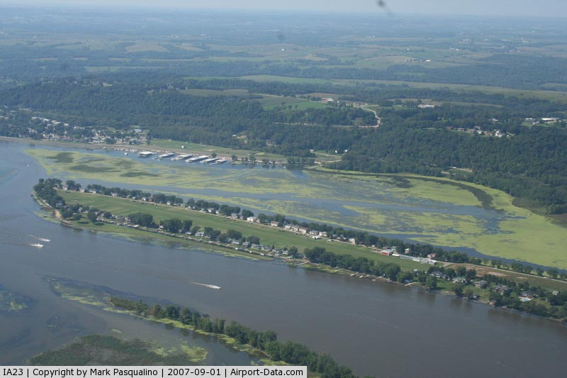
(Click on the photo to enlarge) |
|
 |
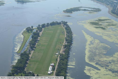
(Click on the photo to enlarge) |
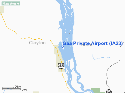
Location &
QuickFacts
|
FAA
Information Effective: |
2007-07-05 |
|
Airport
Identifier: |
IA23 |
|
Airport
Status: |
Operational |
|
Longitude/Latitude: |
091-05-53.4640W/42-48-31.9610N
-91.098184/42.808878 (Estimated) |
|
Elevation: |
620 ft / 188.98 m (Estimated) |
|
Land: |
10 acres |
|
From
nearest city: |
2 nautical miles N of Guttenberg, IA |
|
Location: |
Clayton County, IA |
|
Magnetic Variation: |
01E (1985) |
Owner & Manager
|
Ownership: |
Privately owned |
|
Owner: |
Guttenberg Island Assn |
|
Address: |
Guttenberg, IA 52052 |
|
Manager: |
Guttenberg Aviation |
|
Address: |
Po Box 654
Guttenberg, IA 52052 |
|
Phone number: |
319-252-2050 |
Airport Operations and Facilities
|
Airport Use: |
Private |
|
Wind indicator: |
Yes |
|
Segmented Circle: |
No |
|
Control Tower: |
No |
|
Lighting Schedule: |
DUSK-DAWN |
|
Landing fee charge: |
No |
|
Sectional chart: |
Chicago |
|
Region: |
ACE - Central |
|
Boundary ARTCC: |
ZAU - Chicago |
|
Tie-in FSS: |
FOD - Fort Dodge |
|
FSS on Airport: |
No |
|
FSS Phone: |
515-955-8114 |
|
FSS Toll Free: |
1-800-WX-BRIEF |
Airport Services
|
Airframe
Repair: |
NONE |
|
Power
Plant Repair: |
NONE |
|
Bottled
Oxygen: |
NONE |
|
Bulk
Oxygen: |
NONE |
|
Runway Information
Runway 16/34
|
Dimension: |
2540 x 160 ft / 774.2 x 48.8 m |
|
Surface: |
TURF, Poor Condition |
|
Edge Lights: |
Low |
|
|
Runway 16
|
Runway 34
|
|
Traffic
Pattern: |
Left |
Left |
|
Runway End
Identifier: |
No |
No |
|
Centerline
Lights: |
No |
No |
|
Touchdown
Lights: |
No |
No |
|
Obstruction: |
10 ft road, 10.0 ft from runway |
60 ft trees, 263.0 ft from runway |
|
Radio Navigation Aids
|
ID |
Type |
Name |
Ch |
Freq |
Var |
Dist |
|
PVB |
NDB |
Platteville |
|
203.00 |
01E |
30.1 nm |
|
XWY |
NDB |
West Union |
|
278.00 |
02E |
31.2 nm |
|
MXO |
NDB |
Monticello |
|
397.00 |
01E |
36.6 nm |
|
MRJ |
NDB |
Mineral Point |
|
365.00 |
00W |
38.7 nm |
|
OLZ |
NDB |
Oelwein |
|
260.00 |
02E |
39.5 nm |
|
DEH |
NDB |
Decorah |
|
236.00 |
01E |
39.7 nm |
|
IIB |
NDB |
Wapsie |
|
206.00 |
02E |
43.4 nm |
|
OQW |
NDB |
Maquoketa |
|
386.00 |
02E |
48.2 nm |
|
CHU |
NDB |
Caledonia |
|
209.00 |
03E |
49.8 nm |
|
DBQ |
VORTAC |
Dubuque |
105X |
115.80 |
04E |
29.9 nm |
|
UKN |
VORTAC |
Waukon |
113X |
116.60 |
05E |
34.3 nm |
Remarks
Based Aircraft
|
Aircraft based
on field: |
7 |
|
Single Engine
Airplanes: |
4 |
|
Helicopters: |
1 |
|
Ultralights: |
2 |
Operational Statistics
Time Period: 1985-07-04 - 1986-07-03
|
Aircraft
Operations: |
49/Week |
|
General
Aviation Local: |
60.0% |
|
General
Aviation Itinerant: |
40.0% |
Gaa Private Airport
Address:
Clayton County, IA
Tel:
319-252-2050
Images
and information placed above are from
http://www.airport-data.com/airport/IA23/
We
thank them for the data!
|
General Info |
| Country |
United
States |
| State |
IOWA
|
| FAA ID |
IA23
|
| Latitude |
42-48-31.961N |
|
Longitude |
091-05-53.464W |
|
Elevation |
620 feet
|
| Near
City |
GUTTENBERG |
We don't guarantee the information is fresh and accurate. The data may
be wrong or outdated.
For more up-to-date information please refer to other sources.
|
|