 |
|
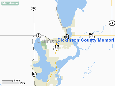
Dickinson County Memorial Hospital Heliport |
Location &
QuickFacts
|
FAA
Information Effective: |
2007-07-05 |
|
Airport
Identifier: |
IA99 |
|
Airport
Status: |
Operational |
|
Longitude/Latitude: |
095-07-25.9820W/43-25-02.8640N
-95.123884/43.417462 (Estimated) |
|
Elevation: |
1455 ft / 443.48 m (Estimated) |
|
Land: |
0 acres |
|
From
nearest city: |
1 nautical miles SW of Spirit Lake, IA |
|
Location: |
Dickinson County, IA |
|
Magnetic Variation: |
05E (1985) |
Owner & Manager
|
Ownership: |
Privately owned |
|
Owner: |
Dickinson County Meml Hosp. |
|
Address: |
Po Box Ab Hwy 71 South
Spirit Lake, IA 51360 |
|
Phone
number: |
712-336-1230 |
|
Manager: |
Michael L Hall |
|
Address: |
Po Box Ab Hwy 71 South
Spirit Lake, IA 51360 |
|
Phone number: |
712-336-1230 |
Airport Operations and Facilities
|
Airport
Use: |
Private
MEDICAL USE. |
|
Wind
indicator: |
Yes |
|
Segmented Circle: |
No |
|
Control
Tower: |
No |
|
Sectional chart: |
Omaha |
|
Region: |
ACE - Central |
|
Boundary
ARTCC: |
ZMP - Minneapolis |
|
Tie-in
FSS: |
FOD - Fort Dodge |
|
FSS on
Airport: |
No |
|
FSS
Phone: |
515-955-8114 |
|
FSS Toll
Free: |
1-800-WX-BRIEF |
|
Runway Information
Helipad H1
|
Dimension: |
40 x 40 ft / 12.2 x 12.2 m |
|
Surface: |
CONC, |
|
|
Runway H1
|
Runway
|
|
Traffic
Pattern: |
Left |
Left |
|
Radio Navigation Aids
|
ID |
Type |
Name |
Ch |
Freq |
Var |
Dist |
|
MJQ |
NDB |
Jackson |
|
353.00 |
04E |
15.1 nm |
|
PUF |
NDB |
Puff |
|
345.00 |
04E |
17.3 nm |
|
LTU |
NDB |
Little Sioux |
|
326.00 |
05E |
17.5 nm |
|
EGQ |
NDB |
Emmetsburg |
|
410.00 |
04E |
26.4 nm |
|
ISB |
NDB |
Sibley |
|
269.00 |
05E |
27.6 nm |
|
MWM |
NDB |
Windom |
|
203.00 |
03E |
29.6 nm |
|
SHL |
NDB |
Sheldon |
|
338.00 |
05E |
33.4 nm |
|
JYG |
NDB |
St James |
|
260.00 |
04E |
42.2 nm |
|
AXA |
NDB |
Algona |
|
403.00 |
03E |
42.4 nm |
|
CKP |
NDB |
Pilot Rock |
|
423.00 |
05E |
45.3 nm |
|
POH |
NDB |
Pocahontas |
|
428.00 |
06E |
45.4 nm |
|
SBU |
NDB |
Blue Earth |
|
332.00 |
04E |
46.1 nm |
|
ORC |
NDB |
Orange City |
|
521.00 |
05E |
48.4 nm |
|
SLB |
NDB |
Storm Lake |
|
434.00 |
04E |
49.4 nm |
|
SOY |
NDB |
Sioux Center |
|
368.00 |
06E |
49.7 nm |
|
EST |
VOR |
Estherville |
|
110.40 |
07E |
16.6 nm |
|
SPW |
VOR/DME |
Spencer |
037X |
110.00 |
05E |
15.7 nm |
|
OTG |
VOR/DME |
Worthington |
043X |
110.60 |
08E |
24.3 nm |
|
DDL |
VOR/DME |
Sheldon |
023X |
108.60 |
05E |
33.4 nm |
|
FRM |
VOR/DME |
Fairmont |
039X |
110.20 |
07E |
33.5 nm |
Remarks
-
PROVIDED APP/DEP
ARE CLEAR FOR AN 8:1 SLOPE; TRANSITIONAL SURFACE IS CLEAR FOR A 2:1 SLOPE.
Dickinson County Memorial Hospital Heliport
Address:
Dickinson County, IA
Tel:
712-336-1230
Images
and information placed above are from
http://www.airport-data.com/airport/IA99/
We
thank them for the data!
|
General Info |
| Country |
United
States |
| State |
IOWA
|
| FAA ID |
IA99
|
| Latitude |
43-25-02.864N |
|
Longitude |
095-07-25.982W |
|
Elevation |
1455
feet |
| Near
City |
SPIRIT
LAKE |
We don't guarantee the information is fresh and accurate. The data may
be wrong or outdated.
For more up-to-date information please refer to other sources.
|
|


