 |
|
Decorah Municipal Airport |
| Decorah Municipal Airport |
| IATA: DEH â ICAO: KDEH â FAA LID: DEH |
| Summary |
| Airport type |
Public |
| Owner |
City of Decorah |
| Serves |
Decorah, Iowa |
| Elevation AMSL |
1,158 ft / 353 m |
| Coordinates |
43°16â²32â³N 091°44â²22â³W / 43.27556°N 91.73944°W / 43.27556; -91.73944 |
| Runways |
| Direction |
Length |
Surface |
| ft |
m |
| 11/29 |
4,001 |
1,220 |
Concrete |
| Statistics (2007) |
| Aircraft operations |
9,100 |
| Based aircraft |
25 |
| Source: Federal Aviation Administration |
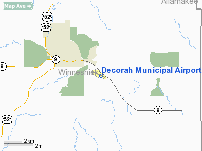
Decorah Municipal Airport (IATA: DEH, ICAO: KDEH, FAA LID: DEH) is a city-owned public-use airport located two nautical miles (3.7 km) southeast of the central business district of Decorah, in Winneshiek County, Iowa, United States.
Facilities and aircraft
Decorah Municipal Airport covers an area of 154 acres (62 ha) at an elevation of 1,158 feet (353 m) above mean sea level. It has one runway designated 11/29 with a concrete surface measuring 4,001 by 75 feet (1,220 x 23 m).
For the 12-month period ending July 19, 2007, the airport had 9,100 general aviation aircraft operations, an average of 24 per day. At that time there were 25 aircraft based at this airport: 96% single-engine and 4% ultralight.
The above content comes from Wikipedia and is published under free licenses – click here to read more.
Location &
QuickFacts
|
FAA
Information Effective: |
2007-07-05 |
|
Airport
Identifier: |
DEH |
|
Airport
Status: |
Operational |
|
Longitude/Latitude: |
091-44-21.7460W/43-16-31.8050N
-91.739374/43.275501 (Estimated) |
|
Elevation: |
1157 ft / 352.65 m (Surveyed) |
|
Land: |
154 acres |
|
From
nearest city: |
2 nautical miles SE of Decorah, IA |
|
Location: |
Winneshiek County, IA |
|
Magnetic Variation: |
01E (1995) |
Owner & Manager
|
Ownership: |
Publicly owned |
|
Owner: |
City Of Decorah
DAVE BACCAM ARPT COMM 319-382-2230 |
|
Address: |
400 Clayborne Dr. Po Box 138
Decorah, IA 52101 |
|
Phone number: |
563-382-3651 |
|
Manager: |
Mike Connell |
|
Address: |
1705 Highway 9
Decorah, IA 52101 |
|
Phone number: |
563-382-8338 |
Airport
Operations and Facilities
|
Airport
Use: |
Open to public |
|
Wind
indicator: |
Yes |
|
Segmented Circle: |
No |
|
Control
Tower: |
No |
|
Lighting
Schedule: |
DUSK-DAWN
MIRL RY 11/29 PRESET ON LOW INTST; TO INCR INTST AND ACTVT VASI RY 29
AND REIL RYS 11 & 29 - CTAF. |
|
Beacon
Color: |
Clear-Green (lighted land airport) |
|
Landing
fee charge: |
No |
|
Sectional chart: |
Chicago |
|
Region: |
ACE - Central |
|
Boundary
ARTCC: |
ZMP - Minneapolis |
|
Tie-in
FSS: |
FOD - Fort Dodge |
|
FSS on
Airport: |
No |
|
FSS
Phone: |
515-955-8114 |
|
FSS Toll
Free: |
1-800-WX-BRIEF |
|
NOTAMs
Facility: |
DEH (NOTAM-d service avaliable) |
|
Federal Agreements: |
NGY |
Airport Communications
|
CTAF: |
122.800 |
|
Unicom: |
122.800 |
Airport Services
|
Fuel
available: |
100LLA |
|
Airframe
Repair: |
MAJOR |
|
Power
Plant Repair: |
MAJOR |
|
Bottled
Oxygen: |
NONE |
|
Bulk
Oxygen: |
NONE |
|
Runway Information
Runway 11/29
|
Dimension: |
4001 x 75 ft / 1219.5 x 22.9 m |
|
Surface: |
CONC, Good Condition |
|
Weight Limit: |
Single wheel: 28000 lbs. |
|
Edge Lights: |
Medium |
|
|
Runway 11
|
Runway 29
|
|
Longitude: |
091-44-46.3180W |
091-43-57.1730W |
|
Latitude: |
43-16-40.0800N |
43-16-23.5910N |
|
Elevation: |
1145.00 ft |
1157.00 ft |
|
Alignment: |
115 |
127 |
|
Traffic
Pattern: |
Left |
Left |
|
Markings: |
Non-precision instrument, Fair Condition |
Non-precision instrument, Fair Condition |
|
Crossing
Height: |
0.00 ft |
47.00 ft |
|
VASI: |
|
4-box on left side |
|
Visual
Glide Angle: |
0.00° |
3.50° |
|
Runway End
Identifier: |
Yes |
Yes |
|
Obstruction: |
, 50:1 slope to clear |
68 ft trees, 1869.0 ft from runway, 315 ft left of
centerline, 24:1 slope to clear |
|
Radio Navigation Aids
|
ID |
Type |
Name |
Ch |
Freq |
Var |
Dist |
|
DEH |
NDB |
Decorah |
|
236.00 |
01E |
0.1 nm |
|
CJJ |
NDB |
Cresco |
|
293.00 |
02E |
18.0 nm |
|
XWY |
NDB |
West Union |
|
278.00 |
02E |
20.0 nm |
|
CHU |
NDB |
Caledonia |
|
209.00 |
03E |
21.6 nm |
|
OLZ |
NDB |
Oelwein |
|
260.00 |
02E |
37.0 nm |
|
CCY |
NDB |
Charles City |
|
375.00 |
03E |
40.1 nm |
|
IY |
NDB |
Chukk |
|
417.00 |
03E |
44.2 nm |
|
LSE |
VOR/DME |
La Crosse |
021X |
108.40 |
02E |
41.8 nm |
|
ONA |
VOR/DME |
Winona |
051X |
111.40 |
01E |
48.2 nm |
|
RST |
VOR/DME |
Rochester |
057X |
112.00 |
05E |
48.2 nm |
|
UKN |
VORTAC |
Waukon |
113X |
116.60 |
05E |
8.8 nm |
|
ODI |
VORTAC |
Nodine |
126X |
117.90 |
01E |
40.1 nm |
Remarks
-
HAZARD MARKERS AT
EDGE OF RY 11/29 SAFETY AREA DEFINE START OF DROPOFF.
Based
Aircraft
|
Aircraft based
on field: |
28 |
|
Single Engine
Airplanes: |
26 |
|
Helicopters: |
1 |
|
Ultralights: |
1 |
Operational Statistics
Time Period:
2002-10-02 -
2003-10-01
|
Aircraft
Operations: |
133/Week |
|
General
Aviation Local: |
55.3% |
|
General
Aviation Itinerant: |
44.7% |
Decorah Municipal Airport
Address:
Winneshiek County, IA
Tel:
563-382-3651, 563-382-8338
Images
and information placed above are from
http://www.airport-data.com/airport/DEH/
We
thank them for the data!
|
General Info |
| Country |
United
States |
| State |
IOWA
|
| FAA ID |
DEH
|
| Latitude |
43-16-31.805N |
|
Longitude |
091-44-21.746W |
|
Elevation |
1157
feet |
| Near
City |
DECORAH
|
We don't guarantee the information is fresh and accurate. The data may
be wrong or outdated.
For more up-to-date information please refer to other sources.
|
|


