 |
|
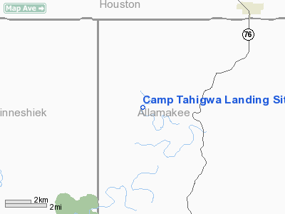
Camp Tahigwa Landing Site Heliport |
Location
& QuickFacts
|
FAA Information Effective: |
2007-07-05 |
|
Airport
Identifier: |
1IA2 |
|
Airport
Status: |
Operational |
|
Longitude/Latitude: |
091-34-02.5150W/43-26-19.8980N
-91.567365/43.438861 (Estimated) |
|
Elevation: |
760 ft / 231.65 m (Estimated) |
|
Land: |
0
acres |
|
From
nearest city: |
3 nautical miles SW of Dorchester, IA |
|
Location: |
Allamakee County, IA |
|
Magnetic Variation: |
02E (1985) |
Owner
& Manager
|
Ownership: |
Army owned |
|
Owner: |
U.s.army Reserve |
|
Address: |
404 W.heivly St.
Decorah, IA 52101 |
|
Phone
number: |
319-382-9684 |
|
Manager: |
Scott A Vandenbos, 1lt |
|
Address: |
404 W.heivly St.
Decorah, IA 52101 |
|
Phone number: |
319-382-9684 |
Airport
Operations and Facilities
|
Airport Use: |
Private |
|
Wind
indicator: |
No |
|
Segmented
Circle: |
No |
|
Control
Tower: |
No |
|
Landing
fee charge: |
No |
|
Sectional
chart: |
Chicago |
|
Region: |
ACE - Central |
|
Boundary
ARTCC: |
ZMP - Minneapolis |
|
Tie-in
FSS: |
FOD - Fort Dodge |
|
FSS
on Airport: |
No |
|
FSS
Phone: |
515-955-8114 |
|
FSS
Toll Free: |
1-800-WX-BRIEF |
|
Runway Information
Helipad H1
|
Dimension: |
100 x 100 ft / 30.5 x 30.5 m |
|
Surface: |
TURF, |
|
|
Runway H1 |
Runway |
|
Traffic
Pattern: |
Left |
Left |
|
Radio Navigation
Aids
|
ID |
Type |
Name |
Ch |
Freq |
Var |
Dist |
|
CHU |
NDB |
Caledonia |
|
209.00 |
03E |
9.5 nm |
|
DEH |
NDB |
Decorah |
|
236.00 |
01E |
12.3 nm |
|
CJJ |
NDB |
Cresco |
|
293.00 |
02E |
25.0 nm |
|
XWY |
NDB |
West Union |
|
278.00 |
02E |
31.2 nm |
|
OLZ |
NDB |
Oelwein |
|
260.00 |
02E |
48.8 nm |
|
LSE |
VOR/DME |
La Crosse |
021X |
108.40 |
02E |
29.6 nm |
|
ONA |
VOR/DME |
Winona |
051X |
111.40 |
01E |
38.8 nm |
|
RST |
VOR/DME |
Rochester |
057X |
112.00 |
05E |
49.3 nm |
|
UKN |
VORTAC |
Waukon |
113X |
116.60 |
05E |
9.6 nm |
|
ODI |
VORTAC |
Nodine |
126X |
117.90 |
01E |
28.8 nm |
Remarks
- CONDITIONAL
- PROVIDED APCH/DEPT PATHS TO LANDING AREA ARE MAINTAINED FOR A MINIMUM
8:1 GLIDE SLOPE AND THE TRANSITIONAL AREA BE MAINTAINED FOR A 2:1 SLOPE.
Camp Tahigwa Landing Site Heliport
Address:
Allamakee County, IA
Tel:
319-382-9684
Images
and information placed above are from
http://www.airport-data.com/airport/1IA2/
We
thank them for the data!
| General
Info |
| Country |
United
States |
| State |
IOWA
|
| FAA ID |
1IA2
|
| Latitude |
43-26-19.898N
|
| Longitude |
091-34-02.515W
|
| Elevation |
760 feet
|
| Near City |
DORCHESTER
|
We don't guarantee the information is fresh and accurate. The data may
be wrong or outdated.
For more up-to-date information please refer to other sources.
|
|


