 |
|
|
|
|
|
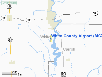
Location & QuickFacts
|
FAA
Information Effective: |
2008-06-05 |
|
Airport
Identifier: |
MCX |
| Airport
Status: |
Operational |
|
Longitude/Latitude: |
086-46-00.3410W/40-42-31.7390N
-86.766761/40.708816 (Estimated) |
|
Elevation: |
676
ft / 206.04 m (Surveyed) |
|
Land: |
51 acres |
| From
nearest city: |
3
nautical miles S of Monticello, IN |
|
Location: |
White County, IN |
|
Magnetic Variation: |
03W
(1995) |
Owner
& Manager
|
Ownership: |
Publicly
owned |
|
Owner: |
White
County Boac |
|
Address: |
2222 Airport Rd
Monticello,
IN 47960 |
|
Phone number: |
574-583-9900 |
|
Manager: |
John Townsend |
|
Address: |
2222
Airport Rd
Monticello,
IN 47960 |
|
Phone
number: |
574-583-9900 |
Airport Operations and Facilities
|
Airport
Use: |
Open
to public |
|
Wind indicator: |
Yes |
|
Segmented
Circle: |
No |
|
Control
Tower: |
No |
|
Lighting
Schedule: |
DUSK-DAWN |
|
Beacon Color: |
Clear-Green
(lighted land airport) |
|
Landing
fee charge: |
No |
|
Sectional
chart: |
Chicago |
|
Region: |
AGL - Great Lakes |
|
Boundary
ARTCC: |
ZAU - Chicago |
|
Tie-in FSS: |
HUF - Terre Haute |
|
FSS on Airport: |
No |
|
FSS Toll
Free: |
1-800-WX-BRIEF |
|
NOTAMs Facility: |
HUF (NOTAM-d
service avaliable) |
|
Federal
Agreements: |
NGY |
Airport
Communications
|
CTAF: |
122.800 |
|
Unicom: |
122.800
|
Airport Services
|
Fuel
available: |
100LLA
FOR SVC AFT HRS CALL 574-583-5888. |
|
Airframe
Repair: |
MAJOR |
|
Power
Plant Repair: |
MAJOR |
|
Runway Information
Runway 18/36
|
Dimension: |
4002 x 60 ft
/ 1219.8 x 18.3 m |
|
Surface: |
ASPH, Good Condition |
| Weight
Limit: |
Single
wheel: 22000 lbs. |
|
Edge Lights: |
Medium |
|
|
Runway 18 |
Runway 36 |
| Longitude: |
086-46-00.9020W |
086-45-59.7600W |
|
Latitude: |
40-42-51.5430N |
40-42-12.0070N |
| Elevation: |
676.00
ft |
670.00
ft |
|
Alignment: |
127 |
127 |
| Traffic
Pattern: |
Left |
Left |
|
Markings: |
Non-precision instrument, Fair Condition |
Non-precision instrument, Fair Condition |
| Crossing
Height: |
21.00
ft |
24.00
ft |
|
VASI: |
2-box on left side |
2-box on left side |
| Visual
Glide Angle: |
3.00° |
4.00° |
|
Runway End
Identifier: |
Yes |
Yes |
| Centerline
Lights: |
No |
No |
|
Touchdown
Lights: |
No |
No |
|
Obstruction: |
15
ft road, 275.0 ft from runway, 5:1 slope to clear |
21
ft trees, 325.0 ft from runway, 220 ft left of centerline,
5:1 slope to clear
DRAINAGE DITCH 100-125'L OF CL -10'. +25'TREES
& +10'BRUSH 205'L OF CL 50-100'FM RWY END. |
|
Radio Navigation Aids
|
ID |
Type |
Name |
Ch |
Freq |
Var |
Dist |
| MCX |
NDB |
White
County |
|
377.00 |
03W |
0.2
nm |
|
GGP |
NDB |
Logansport |
|
263.00 |
01W |
17.9 nm |
| RZL |
NDB |
Rensselaer |
|
362.00 |
02W |
23.8
nm |
|
RWN |
NDB |
Winamac/dcmsnd |
|
335.00 |
00W |
24.3 nm |
| FKR |
NDB |
Frankfort |
|
278.00 |
02W |
27.9
nm |
|
RCR |
NDB |
Rochester |
|
216.00 |
03W |
33.8 nm |
| CPB |
NDB |
Culver |
|
391.00 |
01W |
35.1
nm |
|
IWH |
NDB |
Wabash |
|
329.00 |
03W |
44.3 nm |
| CFJ |
NDB |
Crawfordsville |
|
388.00 |
02W |
44.3
nm |
|
VP |
NDB |
Sedly |
|
212.00 |
02W |
44.9 nm |
| IUL |
NDB |
La
Porte |
|
356.00 |
03W |
47.5
nm |
|
OXI |
VOR/DME |
Knox |
103X |
115.60 |
00E |
37.2 nm |
| BVT |
VORTAC |
Boiler |
098X |
115.10 |
01E |
16.6
nm |
|
GUS |
VORTAC |
Grissom |
21Y |
108.45 |
02W |
28.3 nm |
| OKK |
VORTAC |
Kokomo |
082X |
113.50 |
00E |
34.1
nm |
|
DNV |
VORTAC |
Danville |
047X |
111.00 |
02E |
43.9 nm |
Remarks
- TWY
EDGE MARKED WITH 2' YELLOW CYLINDER REFLECTORS.
- DEER
INVOF ARPT.
- FREQUENT
GLIDER TFC 1000 - SUNSET DAILY DURING APRIL - MID NOVEMBER.
Based Aircraft
|
Aircraft
based on field: |
22 |
|
Single Engine Airplanes: |
18 |
| Multi
Engine Airplanes: |
2 |
|
Gliders: |
2 |
Operational Statistics
Time
Period: 2005-05-23 - 2006-05-22
|
Aircraft
Operations: |
272/Week |
|
Air Taxi: |
13.0% |
| General
Aviation Local: |
60.0% |
|
General Aviation
Itinerant: |
27.0% |
White County Airport
Address:
White County, IN
Tel:
574-583-9900
Images
and information placed above are from
http://www.airport-data.com/airport/MCX/
We
thank them for the data!
| General
Info |
| Country |
United
States |
| State |
INDIANA
|
| FAA ID |
MCX |
| Latitude |
40-42-31.739N
|
| Longitude |
086-46-00.341W
|
| Elevation |
676 feet
|
| Near City |
MONTICELLO
|
We don't guarantee the information is fresh and accurate. The data may
be wrong or outdated.
For more up-to-date information please refer to other sources.
|
|


