|
|
| Westfield Airport |
| IATA: none – ICAO: none – FAA LID: I72 |
| Summary |
| Airport type |
Public |
| Owner |
Leslie Wheeler |
| Serves |
Westfield, Indiana |
| Elevation AMSL |
932 ft / 284 m |
| Coordinates |
40°02′56″N 086°09′28″W / 40.04889°N 86.15778°W / 40.04889; -86.15778 |
| Runways |
| Direction |
Length |
Surface |
| ft |
m |
| 18/36 |
3,000 |
914 |
Turf |
| Statistics (2006) |
| Aircraft operations |
8,075 |
| Based aircraft |
17 |
| Source: Federal Aviation Administration |
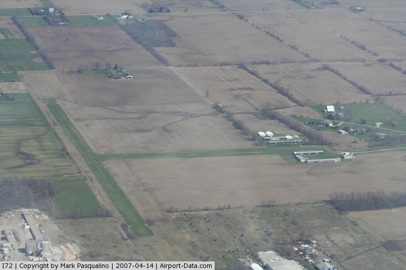
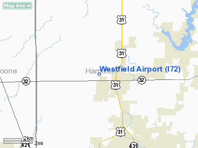
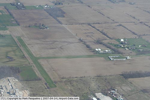
Westfield Airport (FAA LID: I72) is a public use airport located two nautical miles (4 km) west of the central business district of Westfield, a city in Hamilton County, Indiana, United States. It is privately owned by Leslie Wheeler.
The Indy Flyers Light Aircraft Association holds meetings at this airport on the second Wednesday of each month.
Facilities and aircraft
Westfield Airport covers an area of 115 acres (47 ha) at an elevation of 932 feet (284 m) above mean sea level. It has one runway designated 18/36 with a turf surface measuring 3,000 by 100 feet (914 x 30 m). For the 12-month period ending December 31, 2006, the airport had 8,075 general aviation aircraft operations, an average of 22 per day. At that time there were 17 aircraft based at this airport: 59% ultralight and 41% single-engine.
The above content comes from Wikipedia and is published under free licenses – click here to read more.
|
 |
(Click on the photo to enlarge) |
Location & QuickFacts
|
FAA
Information Effective: |
2008-06-05 |
|
Airport
Identifier: |
I72 |
| Airport
Status: |
Operational |
|
Longitude/Latitude: |
086-09-27.9630W/40-02-56.1350N
-86.157767/40.048926 (Estimated) |
|
Elevation: |
932
ft / 284.07 m (Estimated) |
|
Land: |
115 acres |
| From
nearest city: |
2
nautical miles W of Westfield, IN |
|
Location: |
Hamilton County, IN |
|
Magnetic Variation: |
02W
(1985) |
Owner
& Manager
|
Ownership: |
Privately
owned |
|
Owner: |
Leslie
Wheeler |
|
Address: |
18206 Kinsey Ave.
Westfield,
IN 46074 |
|
Phone number: |
317-846-6060 |
|
Manager: |
Andy Wheeler |
|
Address: |
18206
Kinsey Ave
Westfield,
IN 46074 |
|
Phone
number: |
317-896-5521 |
Airport Operations and Facilities
|
Airport
Use: |
Open
to public |
|
Wind indicator: |
Yes |
|
Segmented Circle: |
No |
|
Control
Tower: |
No |
| Landing
fee charge: |
No |
|
Sectional
chart: |
Chicago |
| Region: |
AGL
- Great Lakes |
|
Boundary
ARTCC: |
ZAU - Chicago |
|
Responsible ARTCC: |
ZID
- Indianapolis |
|
Tie-in FSS: |
HUF - Terre Haute |
| FSS
on Airport: |
No |
|
FSS Toll
Free: |
1-800-WX-BRIEF |
| NOTAMs
Facility: |
HUF
(NOTAM-d service avaliable) |
Airport
Communications
Airport
Services
|
Airframe
Repair: |
NONE |
|
Power
Plant Repair: |
NONE |
| Bottled
Oxygen: |
NONE |
|
Bulk Oxygen: |
NONE |
|
Runway Information
Runway 18/36
|
Dimension: |
3000 x 100
ft / 914.4 x 30.5 m
RY 18/36 S 200 FT CLSD INDEFLY. |
|
Surface: |
TURF, Good Condition |
|
|
Runway 18 |
Runway 36 |
| Longitude: |
086-09-36.9600W |
086-09-37.6000W |
|
Latitude: |
40-03-12.1300N |
40-02-42.4800N |
| Elevation: |
930.00
ft |
930.00
ft |
|
Traffic Pattern: |
Left |
Left |
| Runway
End Identifier: |
No |
No |
|
Centerline
Lights: |
No |
No |
| Touchdown
Lights: |
No |
No |
|
Obstruction: |
10 ft crops, 200.0 ft from runway, 20:1 slope
to clear |
40 ft trees, 1600.0 ft from runway, 40:1 slope
to clear |
|
Radio Navigation Aids
|
ID |
Type |
Name |
Ch |
Freq |
Var |
Dist |
| HZP |
NDB |
Zionsville |
|
248.00 |
03W |
7.8
nm |
|
UMP |
NDB |
Metropolitan |
|
338.00 |
03W |
8.3 nm |
| FKR |
NDB |
Frankfort |
|
278.00 |
02W |
22.9
nm |
|
HFY |
NDB |
Greenwood |
|
398.00 |
02W |
25.2 nm |
| AI |
NDB |
Video |
|
371.00 |
03W |
29.8
nm |
|
CFJ |
NDB |
Crawfordsville |
|
388.00 |
02W |
35.1 nm |
| TVX |
NDB |
Greencastle |
|
521.00 |
03W |
36.0
nm |
|
UWL |
NDB |
New Castle |
|
385.00 |
02W |
40.0 nm |
| GGP |
NDB |
Logansport |
|
263.00 |
01W |
40.9
nm |
|
IWH |
NDB |
Wabash |
|
329.00 |
03W |
46.0 nm |
| BA |
NDB |
Clifs |
|
410.00 |
03W |
46.4
nm |
|
MCX |
NDB |
White County |
|
377.00 |
03W |
48.4 nm |
| MZZ |
VOR/DME |
Marion |
023X |
108.60 |
03W |
34.6
nm |
|
MIE |
VOR/DME |
Muncie |
091X |
114.40 |
03W |
36.9 nm |
| VHP |
VORTAC |
Brickyard |
110X |
116.30 |
01E |
17.1
nm |
|
OKK |
VORTAC |
Kokomo |
082X |
113.50 |
00E |
29.1 nm |
| SHB |
VORTAC |
Shelbyville |
057X |
112.00 |
01E |
29.4
nm |
|
GUS |
VORTAC |
Grissom |
21Y |
108.45 |
02W |
35.8 nm |
| IND |
VOT |
Indianapolis
Intl |
|
109.60 |
|
20.3
nm |
Remarks
- NO
SNOW REMOVAL DURING WINTER MONTHS.
- SEASONAL
CROPS 50 FT EACH SIDE OF CNTRLN ENTIRE LENGTH OF FIELD.
- TREES
& BUSHES 100 FT WEST OF CNTRLN PENETRATE PRIM SFC AREA.
- TREES;
BRUSH & FENCE 100 FT WEST OF RY CNTRLN.
- EXISTED
PRIOR TO 1959.
Based Aircraft
|
Aircraft
based on field: |
17 |
|
Single Engine Airplanes: |
7 |
| Ultralights: |
10 |
Operational Statistics
Time
Period: 2006-01-01 - 2006-12-31
|
Aircraft
Operations: |
156/Week |
| General
Aviation Local: |
74.8% |
|
General Aviation
Itinerant: |
25.2% |
Westfield Airport
Address:
Hamilton County, IN
Tel:
317-846-6060,
317-896-5521
Images
and information placed above are from
http://www.airport-data.com/airport/I72/
We
thank them for the data!
| General
Info |
| Country |
United
States |
| State |
INDIANA
|
| FAA ID |
I72 |
| Latitude |
40-02-56.135N
|
| Longitude |
086-09-27.963W
|
| Elevation |
932 feet
|
| Near City |
WESTFIELD
|
We don't guarantee the information is fresh and accurate. The data may
be wrong or outdated.
For more up-to-date information please refer to other sources.
|
|