 |
|
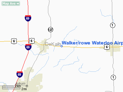
Walker/rowe Waterloo Airport |
|
 |
(Click on the photo to enlarge) |
Location & QuickFacts
|
FAA
Information Effective: |
2008-06-05 |
|
Airport
Identifier: |
4C2 |
| Airport
Status: |
Operational |
|
Longitude/Latitude: |
084-58-53.8740W/41-25-52.1810N
-84.981632/41.431161 (Estimated) |
|
Elevation: |
900
ft / 274.32 m (Estimated) |
|
Land: |
25 acres |
| From
nearest city: |
3
nautical miles E of Waterloo, IN |
|
Location: |
De Kalb County, IN |
|
Magnetic Variation: |
04W
(1985) |
Owner
& Manager
|
Ownership: |
Privately
owned |
|
Owner: |
Richard
D. Rowe |
|
Address: |
4597 Us 6
Waterloo, IN 46793 |
|
Phone number: |
260-837-4403 |
|
Manager: |
Richard D Rowe |
|
Address: |
5584
County Road 40
Butler, IN 46721 |
|
Phone
number: |
260-925-3657 |
Airport Operations and Facilities
|
Airport
Use: |
Open
to public |
|
Wind indicator: |
Yes |
|
Segmented Circle: |
No |
|
Control
Tower: |
No |
| Landing
fee charge: |
No |
|
Sectional
chart: |
Detroit |
| Region: |
AGL
- Great Lakes |
|
Traffic
Pattern Alt: |
800 ft |
| Boundary
ARTCC: |
ZOB
- Cleveland |
|
Tie-in FSS: |
HUF - Terre Haute |
| FSS
on Airport: |
No |
|
FSS Toll
Free: |
1-800-WX-BRIEF |
| NOTAMs
Facility: |
HUF
(NOTAM-d service avaliable) |
Airport
Communications
|
CTAF: |
122.800 |
|
Unicom: |
122.800
|
Airport
Services
|
Fuel
available: |
100LLMOGAS |
|
Power
Plant Repair: |
MINOR
FOR SCHEDULED MAINT CALL 260-837-4403 OR 260-908-3275. |
|
Bottled
Oxygen: |
NONE |
| Bulk
Oxygen: |
NONE |
|
Runway Information
Runway 09/27
|
Dimension: |
2340 x 100 ft
/ 713.2 x 30.5 m |
| Surface: |
TURF,
Fair Condition |
|
|
Runway 09 |
Runway 27 |
|
Longitude: |
084-59-07.3500W |
084-58-36.6500W |
| Latitude: |
41-25-52.4000N |
41-25-51.6000N |
|
Elevation: |
900.00 ft |
900.00 ft |
| Traffic
Pattern: |
Left |
Left |
|
Displaced
threshold: |
300.00 ft |
320.00 ft |
| Runway
End Identifier: |
No |
No |
|
Centerline
Lights: |
No |
No |
| Touchdown
Lights: |
No |
No |
|
Obstruction: |
10 ft road
RY 09 APCH RATIO 30:1 AT DSPLCD THLD. |
10 ft road, 0.0 ft from runway
RY 27 APCH RATIO 32:1 AT DSPLCD THLD. |
|
Radio Navigation Aids
|
ID |
Type |
Name |
Ch |
Freq |
Var |
Dist |
| ANQ |
NDB |
Angola |
|
347.00 |
05W |
13.4
nm |
|
BYN |
NDB |
Bryan |
|
260.00 |
04W |
23.4 nm |
| DFI |
NDB |
Defiance |
|
246.00 |
05W |
25.7
nm |
|
IRS |
NDB |
Sturgis |
|
382.00 |
04W |
30.7 nm |
| VFU |
NDB |
Stanley |
|
411.00 |
05W |
38.0
nm |
|
USE |
NDB |
Fulton |
|
375.00 |
05W |
39.7 nm |
| HHG |
NDB |
Huntington |
|
417.00 |
03W |
40.9
nm |
|
HAI |
NDB |
Three Rivers |
|
407.00 |
02W |
41.9 nm |
| ADG |
NDB |
Adrian |
|
278.00 |
06W |
48.4
nm |
|
OLK |
VOR |
Wolf Lake |
|
110.40 |
03W |
25.8 nm |
| LFD |
VOR/DME |
Litchfield |
049X |
111.20 |
05W |
39.2
nm |
|
FWA |
VORTAC |
Fort Wayne |
125X |
117.80 |
00E |
28.7 nm |
| GSH |
VORTAC |
Goshen |
084X |
113.70 |
00E |
47.5
nm |
|
FWA |
VOT |
Fort Wayne Baer |
|
111.00 |
|
28.8 nm |
Remarks
- RY
09 38 FT TREES 780 FT FROM RY END.
- RY
27 60 FT TREES 1405 FT FROM RY END & 160 FT FACTORY SILOS 1990 FT
FROM RY END & 400 FT SOUTH.
- FOR
FUEL CALL 260-837-4403.
- PRVDD
OBSTRUCTION LOWERED/REMOVED TO PRVD CLEAR 20:1 AREA 125 FT EITHER SIDE
& 240 FT OFF ENDS HAS NO HAZARD.
Based Aircraft
|
Aircraft
based on field: |
11 |
|
Single Engine Airplanes: |
5 |
| Ultralights: |
6 |
Operational Statistics
Time
Period: 2006-01-01 - 2006-12-31
|
Aircraft
Operations: |
53/Week |
| General
Aviation Local: |
90.9% |
|
General Aviation
Itinerant: |
9.1% |
Walker/rowe Waterloo Airport
Address:
De Kalb County, IN
Tel:
260-837-4403,
260-925-3657
Images
and information placed above are from
http://www.airport-data.com/airport/4C2/
We
thank them for the data!
| General
Info |
| Country |
United
States |
| State |
INDIANA
|
| FAA ID |
4C2 |
| Latitude |
41-25-52.181N
|
| Longitude |
084-58-53.874W
|
| Elevation |
900 feet
|
| Near City |
WATERLOO
|
We don't guarantee the information is fresh and accurate. The data may
be wrong or outdated.
For more up-to-date information please refer to other sources.
|
|


