 |
|
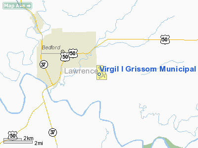
Virgil I Grissom Municipal Airport |
| Virgil I. Grissom Municipal Airport |
| IATA: BFR â ICAO: KBFR â FAA LID: BFR |
| Summary |
| Airport type |
Public |
| Owner |
Lawrence County BOAC |
| Serves |
Bedford, Indiana |
| Elevation AMSL |
728 ft / 222 m |
| Coordinates |
38°50â²24â³N 086°26â²43â³W / 38.84°N 86.44528°W / 38.84; -86.44528 |
| Runways |
| Direction |
Length |
Surface |
| ft |
m |
| 13/31 |
4,501 |
1,372 |
Asphalt |
| 6/24 |
3,089 |
942 |
Asphalt |
| Statistics (2007) |
| Aircraft operations |
5,110 |
| Based aircraft |
35 |
| Source: Federal Aviation Administration |
Virgil I. Grissom Municipal Airport (IATA: BFR, ICAO: KBFR, FAA LID: BFR) is a public use airport located three nautical miles (6 km) southeast of the central business district of Bedford, a city in Lawrence County, Indiana, United States.
The airport is named in honor of Virgil I. Grissom (1926-1967), an Indiana native and U.S. Air Force pilot who was one of the original NASA Project Mercury astronauts.
Facilities and aircraft
Virgil I. Grissom Municipal Airport covers an area of 145 acres (59 ha) at an elevation of 728 feet (222 m) above mean sea level. It has two asphalt paved runways: 13/31 is 4,501 by 100 feet (1,372 x 30 m) and 6/24 is 3,089 by 70 feet (942 x 21 m).
For the 12-month period ending December 30, 2007, the airport had 5,110 aircraft operations, an average of 14 per day: 93% general aviation, 4% air taxi and 3% military. At that time there were 35 aircraft based at this airport: 97% single-engine and 3% multi-engine.
The above content comes from Wikipedia and is published under free licenses – click here to read more.
Location & QuickFacts
|
FAA
Information Effective: |
2008-06-05 |
|
Airport
Identifier: |
BFR |
| Airport
Status: |
Operational |
|
Longitude/Latitude: |
086-26-43.3090W/38-50-24.1190N
-86.445364/38.840033 (Estimated) |
|
Elevation: |
728
ft / 221.89 m (Surveyed) |
|
Land: |
130 acres |
| From
nearest city: |
3
nautical miles SE of Bedford, IN |
|
Location: |
Lawrence County, IN |
|
Magnetic Variation: |
02W
(1995) |
Owner
& Manager
|
Ownership: |
Publicly
owned |
|
Owner: |
Lawrence
County Boac |
|
Address: |
3213 Tunnelton Rd.
Bedford,
IN 47421 |
|
Phone number: |
812-275-0491 |
|
Manager: |
Steve Cummings |
|
Address: |
3213
Tunnelton Rd.
Bedford,
IN 47421 |
|
Phone
number: |
812-275-0491 |
Airport Operations and Facilities
|
Airport
Use: |
Open
to public |
|
Wind indicator: |
Yes |
|
Segmented Circle: |
No |
|
Control
Tower: |
No |
| Lighting
Schedule: |
DUSK-DAWN
MIRL 13/31 PRESET LOW INTST, TO INCR INTST & ACTVT REILS
13/31 - 122.8. |
|
Beacon Color: |
Clear-Green (lighted land airport) |
| Landing
fee charge: |
No |
|
Sectional
chart: |
St Louis |
| Region: |
AGL
- Great Lakes |
|
Traffic
Pattern Alt: |
800 ft |
| Boundary
ARTCC: |
ZID
- Indianapolis |
|
Tie-in FSS: |
HUF - Terre Haute |
| FSS
on Airport: |
No |
|
FSS Toll
Free: |
1-800-WX-BRIEF |
| NOTAMs
Facility: |
HUF
(NOTAM-d service avaliable) |
|
Federal
Agreements: |
NGY |
Airport
Communications
|
CTAF: |
122.800 |
|
Unicom: |
122.800
|
Airport Services
|
Fuel
available: |
100LLA |
|
Airframe
Repair: |
MAJOR |
|
Power
Plant Repair: |
MAJOR |
|
Runway Information
Runway 06/24
|
Dimension: |
3089 x 70 ft
/ 941.5 x 21.3 m |
| Surface: |
ASPH,
Good Condition |
|
Weight Limit: |
Single wheel: 4000 lbs. |
|
|
Runway 06 |
Runway 24 |
| Longitude: |
086-26-53.1980W |
086-26-20.2670W |
|
Latitude: |
38-50-07.3400N |
38-50-23.7360N |
| Elevation: |
714.00
ft |
723.00
ft |
|
Alignment: |
58 |
127 |
| Traffic
Pattern: |
Left |
Left |
|
Markings: |
Basic, Fair Condition |
Basic, Fair Condition |
| Runway
End Identifier: |
No |
No |
|
Centerline
Lights: |
No |
No |
| Touchdown
Lights: |
No |
No |
|
Obstruction: |
15 ft road, 220.0 ft from runway, 1:1 slope
to clear
5' DITCH 20' WIDE 120' FRM THR. ALSO
BRUSH 145' FROM THR. |
47 ft trees, 600.0 ft from runway, 8:1 slope
to clear
-10' DWNSLP TERRAIN AND BRUSH 100-200' FRM RWY END. |
|
Runway 13/31
|
Dimension: |
4501 x 100 ft
/ 1371.9 x 30.5 m |
|
Surface: |
ASPH, Good Condition |
| Weight
Limit: |
Single wheel: 25000 lbs.
Dual wheel: 30000 lbs. |
|
Edge Lights: |
Medium |
|
|
Runway 13 |
Runway 31 |
| Longitude: |
086-27-09.8280W |
086-26-25.8230W |
|
Latitude: |
38-50-44.1010N |
38-50-15.9050N |
| Elevation: |
713.00
ft |
724.00
ft |
|
Alignment: |
127 |
127 |
| Traffic
Pattern: |
Left |
Left |
|
Markings: |
Non-precision instrument, Good Condition |
Non-precision instrument, Good Condition |
| Crossing
Height: |
0.00
ft |
31.00
ft |
|
VASI: |
|
2-box on left side |
| Visual
Glide Angle: |
0.00° |
3.00° |
|
Runway End
Identifier: |
Yes |
Yes |
| Centerline
Lights: |
No |
No |
|
Touchdown
Lights: |
No |
No |
|
Obstruction: |
15
ft trees, 201.0 ft from runway, 200 ft right of centerline
+10'TREES 0-160'FM THR &190'R OF CL; SLOPING TERRAIN 0-6'BGNG
100'FM RWY END TO 200'. |
85
ft tree, 1950.0 ft from runway, 280 ft left of centerline,
20:1 slope to clear
15' DROPOFF 160' FRM THR ON CNTRLN. |
|
Radio Navigation Aids
|
ID |
Type |
Name |
Ch |
Freq |
Var |
Dist |
| BFR |
NDB |
Bedford |
|
344.00 |
02W |
0.4
nm |
|
BM |
NDB |
Claye |
|
382.00 |
02W |
14.9 nm |
| RRJ |
NDB |
Oranj |
|
368.00 |
02W |
19.2
nm |
|
EQZ |
NDB |
Captain |
|
308.00 |
02W |
22.2 nm |
| DCY |
NDB |
Washington |
|
212.00 |
03W |
33.3
nm |
|
FNZ |
NDB |
Ferdinand |
|
239.00 |
00E |
40.0 nm |
| BA |
NDB |
Clifs |
|
410.00 |
03W |
41.2
nm |
|
OVO |
NDB |
North Vernon |
|
374.00 |
02W |
41.4 nm |
| IMS |
NDB |
Madison |
|
404.00 |
03W |
46.4
nm |
|
SIV |
NDB |
Sullivan |
|
326.00 |
02W |
49.6 nm |
| HNB |
VOR/DME |
Huntingburg |
029X |
109.20 |
00E |
42.8
nm |
|
OOM |
VORTAC |
Hoosier |
039X |
110.20 |
02W |
19.9 nm |
| ABB |
VORTAC |
Nabb |
071X |
112.40 |
01E |
40.9
nm |
Remarks
- RY
13/31 HAS SMALL TREES AND BRUSH 200 FT L & R OF CNTRLN ENTIRE RY
LENGTH.
- RWY
13: -10 TO -20'DWNSLP TERRAIN AT THR 190'R OF CL.
- CTN:
LINE OF SIGHT RSTRNS TO VSBY.
- DEER
ON & INVOF ARPT.
Based Aircraft
|
Aircraft
based on field: |
30 |
|
Single Engine Airplanes: |
26 |
| Multi
Engine Airplanes: |
1 |
|
Jet Engine Airplanes: |
1 |
| Helicopters: |
1 |
|
Ultralights: |
1 |
Operational Statistics
Time
Period: 2004-01-01 - 2004-12-30
|
Aircraft
Operations: |
60/Day |
|
Air Taxi: |
3.8% |
| General
Aviation Local: |
43.7% |
|
General Aviation
Itinerant: |
49.1% |
| Military: |
3.4% |
Virgil I Grissom Municipal Airport
Address:
Lawrence County, IN
Tel:
812-275-0491
Images
and information placed above are from
http://www.airport-data.com/airport/BFR/
We
thank them for the data!
| General
Info |
| Country |
United
States |
| State |
INDIANA
|
| FAA ID |
BFR |
| Latitude |
38-50-24.119N
|
| Longitude |
086-26-43.309W
|
| Elevation |
728 feet
|
| Near City |
BEDFORD
|
We don't guarantee the information is fresh and accurate. The data may
be wrong or outdated.
For more up-to-date information please refer to other sources.
|
|


