 |
|
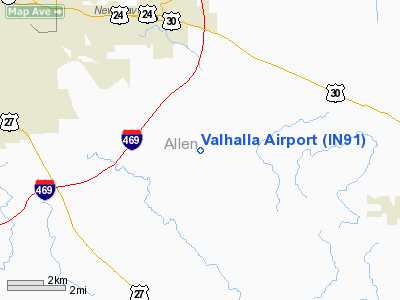
Location & QuickFacts
|
FAA
Information Effective: |
2008-06-05 |
|
Airport
Identifier: |
IN91 |
| Airport
Status: |
Operational |
|
Longitude/Latitude: |
084-59-30.8820W/41-00-08.1730N
-84.991912/41.002270 (Estimated) |
|
Elevation: |
810
ft / 246.89 m (Estimated) |
|
Land: |
20 acres |
| From
nearest city: |
2
nautical miles SW of Maples, IN |
|
Location: |
Allen County, IN |
|
Magnetic Variation: |
04W
(1985) |
Owner & Manager
|
Ownership: |
Privately
owned |
| Owner: |
Lester
Zehr
CO-OWNER DICK RITTER |
|
Address: |
11127 Rohrbach Rd
Fort
Wayne, IN 48616 |
| Phone
number: |
260-639-6521 |
|
Manager: |
Lester Zehr |
| Address: |
11127
Rohrbach Rd
Fort
Wayne, IN 48616 |
|
Phone
number: |
260-639-6521 |
Airport
Operations and Facilities
|
Airport
Use: |
Private |
|
Wind indicator: |
Yes |
|
Segmented Circle: |
No |
|
Control
Tower: |
No |
| Landing
fee charge: |
No |
|
Sectional
chart: |
Chicago |
| Region: |
AGL
- Great Lakes |
|
Boundary
ARTCC: |
ZAU - Chicago |
| Tie-in
FSS: |
HUF
- Terre Haute |
|
FSS on Airport: |
No |
| FSS
Toll Free: |
1-800-WX-BRIEF |
|
Runway Information
Runway N/S
|
Dimension: |
2400 x 130 ft
/ 731.5 x 39.6 m |
| Surface: |
TURF,
|
|
|
Runway N |
Runway S |
|
Traffic Pattern: |
Right |
Left |
|
Radio Navigation Aids
|
ID |
Type |
Name |
Ch |
Freq |
Var |
Dist |
| VFU |
NDB |
Stanley |
|
411.00 |
05W |
19.1
nm |
|
HHG |
NDB |
Huntington |
|
417.00 |
03W |
23.2 nm |
| DFI |
NDB |
Defiance |
|
246.00 |
05W |
32.4
nm |
|
PLD |
NDB |
Portland |
|
257.00 |
03W |
33.0 nm |
| CQA |
NDB |
Lakefield |
|
205.00 |
04W |
36.8
nm |
|
BYN |
NDB |
Bryan |
|
260.00 |
04W |
37.3 nm |
| ANQ |
NDB |
Angola |
|
347.00 |
05W |
38.6
nm |
|
IWH |
NDB |
Wabash |
|
329.00 |
03W |
39.3 nm |
| PDR |
NDB |
Ottawa |
|
233.00 |
05W |
46.1
nm |
|
LYL |
NDB |
Lima |
|
362.00 |
04W |
47.5 nm |
| OLK |
VOR |
Wolf
Lake |
|
110.40 |
03W |
27.2
nm |
|
AOH |
VOR |
Allen County |
|
108.40 |
04W |
49.8 nm |
| MZZ |
VOR/DME |
Marion |
023X |
108.60 |
03W |
43.8
nm |
|
MIE |
VOR/DME |
Muncie |
091X |
114.40 |
03W |
49.5 nm |
| FWA |
VORTAC |
Fort
Wayne |
125X |
117.80 |
00E |
9.0
nm |
|
FWA |
VOT |
Fort Wayne Baer |
|
111.00 |
|
9.2 nm |
Remarks
- PROVIDED
ALL OPNS ARE CONDUCTED ON WEST SIDE OF N/S RWY.
Based Aircraft
|
Aircraft
based on field: |
3 |
|
Single Engine Airplanes: |
3 |
Valhalla Airport
Address:
Allen County, IN
Tel:
260-639-6521
Images
and information placed above are from
http://www.airport-data.com/airport/IN91/
We
thank them for the data!
| General
Info |
| Country |
United
States |
| State |
INDIANA
|
| FAA ID |
IN91 |
| Latitude |
41-00-08.173N
|
| Longitude |
084-59-30.882W
|
| Elevation |
810 feet
|
| Near City |
MAPLES
|
We don't guarantee the information is fresh and accurate. The data may
be wrong or outdated.
For more up-to-date information please refer to other sources.
|
|


