 |
|
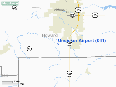
Location & QuickFacts
|
FAA
Information Effective: |
2008-06-05 |
|
Airport
Identifier: |
0II1 |
| Airport
Status: |
Operational |
|
Longitude/Latitude: |
086-09-11.9720W/40-25-41.1360N
-86.153326/40.428093 (Estimated) |
|
Elevation: |
816
ft / 248.72 m (Estimated) |
|
Land: |
0 acres |
| From
nearest city: |
1
nautical miles NW of Bremen, IN |
|
Location: |
Marshall County, IN |
|
Magnetic Variation: |
02W
(1985) |
Owner
& Manager
|
Ownership: |
Privately
owned |
|
Owner: |
Robert
Unsicker |
|
Address: |
Rt 1, 3310 Fir
Bremen, IN 46506 |
|
Phone number: |
219-546-2789 |
|
Manager: |
Robert Unsicker |
|
Address: |
Rt
1, 3310 Fir
Bremen, IN 46506 |
|
Phone
number: |
219-546-2789 |
Airport Operations and Facilities
|
Airport
Use: |
Private |
|
Wind indicator: |
Yes |
|
Segmented Circle: |
No |
|
Control
Tower: |
No |
|
Sectional chart: |
Chicago |
|
Region: |
AGL - Great Lakes |
| Boundary
ARTCC: |
ZAU
- Chicago |
|
Tie-in FSS: |
HUF - Terre Haute |
| FSS
on Airport: |
No |
|
FSS Toll
Free: |
1-800-WX-BRIEF |
|
Runway Information
Runway 09/27
|
Dimension: |
1300 x 60 ft
/ 396.2 x 18.3 m |
|
Surface: |
TURF, |
|
|
Runway 09 |
Runway 27 |
| Traffic
Pattern: |
Left |
Left |
|
Radio Navigation Aids
|
ID |
Type |
Name |
Ch |
Freq |
Var |
Dist |
| GGP |
NDB |
Logansport |
|
263.00 |
01W |
19.7
nm |
|
FKR |
NDB |
Frankfort |
|
278.00 |
02W |
21.0 nm |
| IWH |
NDB |
Wabash |
|
329.00 |
03W |
25.9
nm |
|
HZP |
NDB |
Zionsville |
|
248.00 |
03W |
29.7 nm |
| UMP |
NDB |
Metropolitan |
|
338.00 |
03W |
29.9
nm |
|
MCX |
NDB |
White County |
|
377.00 |
03W |
32.6 nm |
| AI |
NDB |
Video |
|
371.00 |
03W |
36.5
nm |
|
RCR |
NDB |
Rochester |
|
216.00 |
03W |
38.3 nm |
| HHG |
NDB |
Huntington |
|
417.00 |
03W |
40.6
nm |
|
CFJ |
NDB |
Crawfordsville |
|
388.00 |
02W |
44.1 nm |
| RWN |
NDB |
Winamac/dcmsnd |
|
335.00 |
00W |
45.0
nm |
|
HFY |
NDB |
Greenwood |
|
398.00 |
02W |
47.9 nm |
| CPB |
NDB |
Culver |
|
391.00 |
01W |
48.6
nm |
|
MZZ |
VOR/DME |
Marion |
023X |
108.60 |
03W |
22.0 nm |
| MIE |
VOR/DME |
Muncie |
091X |
114.40 |
03W |
36.6
nm |
|
OKK |
VORTAC |
Kokomo |
082X |
113.50 |
00E |
7.4 nm |
| GUS |
VORTAC |
Grissom |
21Y |
108.45 |
02W |
13.0
nm |
|
VHP |
VORTAC |
Brickyard |
110X |
116.30 |
01E |
38.2 nm |
| BVT |
VORTAC |
Boiler |
098X |
115.10 |
01E |
42.6
nm |
|
IND |
VOT |
Indianapolis Intl |
|
109.60 |
|
42.7 nm |
Based Aircraft
|
Aircraft
based on field: |
1 |
|
Single Engine Airplanes: |
1 |
Unsicker Airport
Address:
Marshall County, IN
Tel:
219-546-2789
Images
and information placed above are from
http://www.airport-data.com/airport/0II1/
We
thank them for the data!
| General
Info |
| Country |
United
States |
| State |
INDIANA
|
| FAA ID |
0II1 |
| Latitude |
40-25-41.136N
|
| Longitude |
086-09-11.972W
|
| Elevation |
816 feet
|
| Near City |
BREMEN
|
We don't guarantee the information is fresh and accurate. The data may
be wrong or outdated.
For more up-to-date information please refer to other sources.
|
|


