 |
|
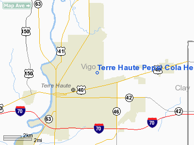
Terre Haute Pepsi Cola Heliport |
Location & QuickFacts
|
FAA
Information Effective: |
2008-06-05 |
|
Airport
Identifier: |
6II3 |
| Airport
Status: |
Operational |
|
Longitude/Latitude: |
087-21-33.0690W/39-29-19.1330N
-87.359186/39.488648 (Estimated) |
|
Elevation: |
502
ft / 153.01 m (Estimated) |
|
Land: |
0 acres |
| From
nearest city: |
0
nautical miles N of Terre Haute, IN |
|
Location: |
Vigo County, IN |
|
Magnetic Variation: |
01W
(1985) |
Owner & Manager
|
Ownership: |
Privately
owned |
| Owner: |
Terre
Haute Pepsi Cola Co |
|
Address: |
1025 N Fruitridge Ave
Terre
Haute, IN 47884 |
| Phone
number: |
217-522-6321 |
|
Manager: |
Jon D. Vecchie |
| Address: |
P.o.
Box 2704
Tallahassee,
FL 32312 |
|
Phone
number: |
904-574-0281 |
Airport
Operations and Facilities
|
Airport
Use: |
Private |
|
Wind indicator: |
Yes |
|
Segmented Circle: |
No |
|
Control
Tower: |
No |
|
Sectional chart: |
St
Louis |
|
Region: |
AGL - Great Lakes |
| Boundary
ARTCC: |
ZID
- Indianapolis |
|
Tie-in FSS: |
HUF - Terre Haute |
| FSS
Toll Free: |
1-800-WX-BRIEF |
|
Runway Information
Helipad H1
|
Dimension: |
15 x 15 ft /
4.6 x 4.6 m |
| Surface: |
CONC,
|
|
|
Runway H1 |
Runway |
|
Traffic Pattern: |
Left |
Left |
|
Radio Navigation Aids
|
ID |
Type |
Name |
Ch |
Freq |
Var |
Dist |
| HU |
NDB |
Yinno |
|
245.00 |
02W |
6.3
nm |
|
PRG |
NDB |
Paris |
|
341.00 |
01E |
19.3 nm |
| SIV |
NDB |
Sullivan |
|
326.00 |
02W |
22.9
nm |
|
TVX |
NDB |
Greencastle |
|
521.00 |
03W |
29.0 nm |
| PLX |
NDB |
Palestine |
|
391.00 |
00W |
31.4
nm |
|
CZB |
NDB |
Casey |
|
359.00 |
00E |
31.8 nm |
| CFJ |
NDB |
Crawfordsville |
|
388.00 |
02W |
36.0
nm |
|
MT |
NDB |
Zebre |
|
347.00 |
00E |
37.9 nm |
| HMJ |
NDB |
Homer |
|
281.00 |
01E |
42.4
nm |
|
BM |
NDB |
Claye |
|
382.00 |
02W |
43.9 nm |
| OEA |
NDB |
Vincennes |
|
251.00 |
00E |
48.8
nm |
|
DCY |
NDB |
Washington |
|
212.00 |
03W |
48.8 nm |
| RSV |
VOR/DME |
Robinson |
021X |
108.40 |
02E |
31.3
nm |
|
MTO |
VOR/DME |
Mattoon |
031X |
109.40 |
03E |
43.0 nm |
| LWV |
VOR/DME |
Lawrenceville |
025X |
108.80 |
01W |
44.7
nm |
|
TTH |
VORTAC |
Terre Haute |
100X |
115.30 |
02E |
5.1 nm |
| OOM |
VORTAC |
Hoosier |
039X |
110.20 |
02W |
40.4
nm |
|
DNV |
VORTAC |
Danville |
047X |
111.00 |
02E |
49.2 nm |
| VHP |
VORTAC |
Brickyard |
110X |
116.30 |
01E |
49.9
nm |
Remarks
- PRVDD
ALL APCH/DEP ROUTES 350-270 DEGS; TAKEOFF/LDG AREA APPROPRIATELY MKD;
NON-OBSTRUCTING WIND INDICATOR MAINTAINED; LETTER OF AGREEMENT WITH
TERRE HAUTE TWR.
Terre Haute Pepsi Cola Heliport
Address:
Vigo County, IN
Tel:
217-522-6321,
904-574-0281
Images
and information placed above are from
http://www.airport-data.com/airport/6II3/
We
thank them for the data!
| General
Info |
| Country |
United
States |
| State |
INDIANA
|
| FAA ID |
6II3 |
| Latitude |
39-29-19.133N
|
| Longitude |
087-21-33.069W
|
| Elevation |
502 feet
|
| Near City |
TERRE
HAUTE |
We don't guarantee the information is fresh and accurate. The data may
be wrong or outdated.
For more up-to-date information please refer to other sources.
|
|


