|
|
Terre Haute International Airport
Hulman Field |
 |
| IATA: HUF â ICAO: KHUF â FAA LID: HUF |
| Summary |
| Airport type |
Public |
| Owner |
Terre Haute International Airport Authority |
| Location |
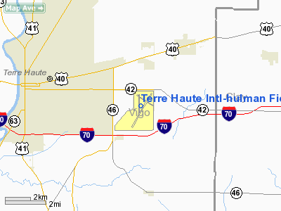
Terre Haute, Indiana |
| Elevation AMSL |
589 ft / 180 m |
| Coordinates |
39°27â²05â³N 087°18â²27â³W / 39.45139°N 87.3075°W / 39.45139; -87.3075 |
| Runways |
| Direction |
Length |
Surface |
| ft |
m |
| 5/23 |
9,020 |
2,749 |
Asphalt |
| 14/32 |
7,200 |
2,195 |
Asphalt/Concrete |
| 18/36 |
4,001 |
1,220 |
Asphalt/Concrete |
| Source: Federal Aviation Administration |
Terre Haute International Airport (IATA: HUF, ICAO: KHUF, FAA LID: HUF) is a public airport located five miles (8 km) east of the central business district of Terre Haute, a city in Vigo County, Indiana, United States.
Originally called Hulman Field, the airport dates back to 1943 when ground was broken on a 638-acre (2.58 km) site donated to the city of Terre Haute by businessman Anton "Tony" Hulman, Jr. The airport was dedicated on October 3, 1944 and consisted of three runways, taxiways, apron area, and a terminal building. In 1953, a new terminal building and control tower was completed and the apron area expanded. Since 1954, the 181st Intelligence Wing of the Indiana Air National Guard has been stationed at the airport.
In 1976, the city of Terre Haute and Vigo County jointly formed an authority to manage the airport. The Terre Haute International Airport Authority has six members, with three members appointed by the Mayor of Terre Haute and three members appointed by the Vigo County Commissioners. The terminal building was expanded in 1977 and 1981. In 1998, the Airport's name was changed from Hulman Regional Airport to Terre Haute International Airport - Hulman Field.
Since 2002, Hulman Field has been host to the Terre Haute Air Fair. Distinguished performers at the fair have included the USAF Thunderbirds, the Red Baron Pizza Squadron, and Michael Hunter, the world's only insulin-dependent aerobatics pilot. The Air Fair is run almost entirely by volunteers, but also by community and school organizations looking for fundraising opportunities. Airlines and destinations
There are currently no commercial airlines offering service to Terre Haute. Branson Air Express announced service in February 2010, but later canceled plans to do so citing weak demand.
Facilities
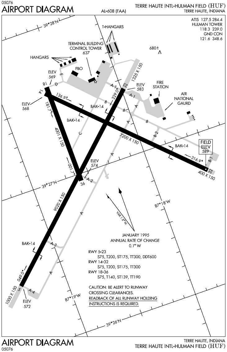
Terre Haute International Airport covers an area of 1,475 acres (597 ha) and contains three runways:
- Runway 5/23: 9,020 x 150 ft (2,749 x 46 m), Surface: Asphalt
- Runway 14/32: 7,200 x 150 ft (2,195 x 46 m), Surface: Asphalt/Concrete
- Runway 18/36: 4,001 x 150 ft (1,220 x 46 m), Surface: Asphalt/Concrete
Hulman Field provided "puddle jumper" passenger service up until after 1975 and is today used by the Federal DOC in support of the Terre Haute Federal Penitentiary using 737 and MD 81 sized aircraft. Indiana State University currently uses Hulman Field for their aviation program. The USAF uses Hulman Field for worldwide command and control of remote control surveillance aircraft. Hulman Field can also support the F-16 and larger military aircraft on an âas neededâ basis.â
The above content comes from Wikipedia and is published under free licenses – click here to read more.
|
 |
(Click on the photo to enlarge) |
Location & QuickFacts
|
FAA
Information Effective: |
2008-06-05 |
|
Airport
Identifier: |
HUF |
| Airport
Status: |
Operational |
|
Longitude/Latitude: |
087-18-27.2200W/39-27-05.2690N
-87.307561/39.451464 (Estimated) |
|
Elevation: |
589
ft / 179.53 m (Surveyed) |
|
Land: |
1475 acres |
| From
nearest city: |
5
nautical miles E of Terre Haute, IN |
|
Location: |
Vigo County, IN |
|
Magnetic Variation: |
02W
(2000) |
Owner & Manager
|
Ownership: |
Publicly
owned |
| Owner: |
Terre
Haute Intl Arpt Auth |
|
Address: |
581 S. Airport St.
Terre
Haute, IN 47803 |
| Phone
number: |
812-877-2524 |
|
Manager: |
Dennis J. Dunbar |
| Address: |
581
S. Airport St.
Terre
Haute, IN 47803 |
|
Phone
number: |
812-877-2524 |
Airport
Operations and Facilities
|
Airport
Use: |
Open
to public |
|
Wind indicator: |
Yes |
|
Segmented Circle: |
No |
|
Control
Tower: |
Yes |
| Lighting
Schedule: |
DUSK-DAWN |
|
Beacon Color: |
Clear-Green (lighted land airport) |
| Landing
fee charge: |
Yes
LNDG FEE FOR CIVILIAN ACFT OVER 10000 LBS. |
|
Sectional
chart: |
St Louis |
| Region: |
AGL
- Great Lakes |
|
Boundary
ARTCC: |
ZID - Indianapolis |
| Tie-in
FSS: |
HUF
- Terre Haute |
|
FSS on Airport: |
No |
| FSS
Toll Free: |
1-800-WX-BRIEF |
|
NOTAMs Facility: |
HUF (NOTAM-d service avaliable) |
|
Certification type/date: |
IV
A U 05/197
ARFF INDEX 'D' AVBL ON REQUEST WITH PPR, CTC AMGR 812-877-2252.
RY 18/36 REMAINS CLSD TO ACR OPNS WITH MORE THAN 30 PSGR
SEATS. |
|
Federal
Agreements: |
NGY3 |
Airport
Communications
Airport Services
|
Fuel
available: |
100LLA |
|
Airframe
Repair: |
MAJOR |
|
Power
Plant Repair: |
MAJOR |
| Bottled
Oxygen: |
NONE |
|
Runway Information
Runway 05/23
|
Dimension: |
9020 x 150
ft / 2749.3 x 45.7 m
1000 FT PAVED BLAST PAD SW END & 1325 FT PAVED BLAST PAD NE
END; RY 32 400 FT BY 150 FT BLAST PAD; NOT AVBL FOR ASDA. |
| Surface: |
ASPH,
Fair Condition |
|
Surface Treatment: |
Saw-cut or plastic Grooved |
| Weight
Limit: |
Single wheel: 75000 lbs.
Dual wheel: 200000 lbs.
Dual tandem wheel: 300000 lbs.
Dual dual tandem wheel: 600000 lbs. |
|
Edge Lights: |
High |
|
|
Runway 05 |
Runway 23 |
| Longitude: |
087-19-23.3620W |
087-17-58.9770W |
|
Latitude: |
39-26-25.8910N |
39-27-26.4480N |
| Elevation: |
572.00
ft |
583.00
ft |
|
Alignment: |
47 |
127 |
| ILS
Type: |
ILS
|
|
|
Traffic Pattern: |
Left |
Left |
| Markings: |
Precision
instrument, Fair Condition |
Precision
instrument, Fair Condition |
|
Arresting: |
BAK14 |
BAK14 |
| Crossing
Height: |
39.00
ft |
31.00
ft |
|
VASI: |
4-light PAPI on left side |
4-box on left side |
| Visual
Glide Angle: |
3.00° |
3.00° |
|
RVR Equipment: |
touchdown |
|
| Approach
lights: |
MALSR |
|
|
Runway End
Identifier: |
No |
Yes |
| Centerline
Lights: |
No |
No |
|
Touchdown
Lights: |
No |
No |
|
Obstruction: |
54
ft stack, 2841.0 ft from runway, 412 ft left of centerline,
48:1 slope to clear |
71
ft tree, 2297.0 ft from runway, 535 ft right of centerline,
29:1 slope to clear |
|
Runway 14/32
|
Dimension: |
7200 x 150
ft / 2194.6 x 45.7 m
1000 FT PAVED BLAST PAD SW END & 1325 FT PAVED BLAST PAD NE
END; RY 32 400 FT BY 150 FT BLAST PAD; NOT AVBL FOR ASDA. |
| Surface: |
ASPH-CONC,
Fair Condition |
|
Surface Treatment: |
Saw-cut or plastic Grooved |
| Weight
Limit: |
Single wheel: 75000 lbs.
Dual wheel: 200000 lbs.
Dual
tandem wheel: 300000 lbs. |
|
Edge Lights: |
High |
|
|
Runway 14 |
Runway 32 |
| Longitude: |
087-18-37.5200W |
087-17-32.5100W |
|
Latitude: |
39-27-34.9300N |
39-26-44.7000N |
| Elevation: |
568.00
ft |
589.00
ft |
|
Alignment: |
127 |
127 |
| Traffic
Pattern: |
Left |
Left |
|
Markings: |
Non-precision instrument, Good Condition |
Non-precision instrument, Good Condition |
| Arresting: |
BAK14 |
BAK14 |
|
Crossing Height: |
55.00 ft |
50.00 ft |
| VASI: |
4-light
PAPI on left side |
4-light
PAPI on left side |
|
Visual Glide
Angle: |
2.75° |
3.00° |
| Runway
End Identifier: |
Yes |
Yes |
|
Centerline
Lights: |
No |
No |
| Touchdown
Lights: |
No |
No |
|
Obstruction: |
105 ft tree, 2597.0 ft from runway, 341 ft
left of centerline, 22:1 slope to clear |
, 50:1 slope to clear |
|
Runway 18/36
|
Dimension: |
4001 x 150
ft / 1219.5 x 45.7 m
1000 FT PAVED BLAST PAD SW END & 1325 FT PAVED BLAST PAD NE
END; RY 32 400 FT BY 150 FT BLAST PAD; NOT AVBL FOR ASDA. |
|
Surface: |
ASPH-CONC, Fair Condition |
| Weight
Limit: |
Single wheel: 75000 lbs.
Dual wheel: 140000 lbs.
Dual
tandem wheel: 190000 lbs. |
|
Edge Lights: |
Medium |
|
|
Runway 18 |
Runway 36 |
| Longitude: |
087-18-35.7760W |
087-18-35.6850W |
|
Latitude: |
39-27-37.3690N |
39-26-57.8320N |
| Elevation: |
569.00
ft |
574.00
ft |
|
Alignment: |
127 |
127 |
| Traffic
Pattern: |
Left |
Left |
|
Markings: |
Basic, Good Condition |
Basic, Good Condition |
| Crossing
Height: |
54.00
ft |
0.00
ft |
|
VASI: |
2-light PAPI on left side |
|
| Visual
Glide Angle: |
3.00° |
0.00° |
|
Runway End
Identifier: |
Yes |
Yes |
| Centerline
Lights: |
No |
No |
|
Touchdown
Lights: |
No |
No |
|
Obstruction: |
83
ft trees, 1765.0 ft from runway, 208 ft left of centerline,
18:1 slope to clear |
87
ft tree, 3057.0 ft from runway, 193 ft right of centerline,
32:1 slope to clear |
|
Radio Navigation Aids
|
ID |
Type |
Name |
Ch |
Freq |
Var |
Dist |
| HU |
NDB |
Yinno |
|
245.00 |
02W |
5.7
nm |
|
SIV |
NDB |
Sullivan |
|
326.00 |
02W |
21.3 nm |
| PRG |
NDB |
Paris |
|
341.00 |
01E |
22.6
nm |
|
TVX |
NDB |
Greencastle |
|
521.00 |
03W |
28.1 nm |
| PLX |
NDB |
Palestine |
|
391.00 |
00W |
30.6
nm |
|
CZB |
NDB |
Casey |
|
359.00 |
00E |
33.4 nm |
| CFJ |
NDB |
Crawfordsville |
|
388.00 |
02W |
36.6
nm |
|
MT |
NDB |
Zebre |
|
347.00 |
00E |
40.2 nm |
| BM |
NDB |
Claye |
|
382.00 |
02W |
40.6
nm |
|
HMJ |
NDB |
Homer |
|
281.00 |
01E |
45.7 nm |
| DCY |
NDB |
Washington |
|
212.00 |
03W |
46.1
nm |
|
OEA |
NDB |
Vincennes |
|
251.00 |
00E |
47.1 nm |
| RSV |
VOR/DME |
Robinson |
021X |
108.40 |
02E |
30.5
nm |
|
LWV |
VOR/DME |
Lawrenceville |
025X |
108.80 |
01W |
43.2 nm |
| MTO |
VOR/DME |
Mattoon |
031X |
109.40 |
03E |
45.4
nm |
|
TTH |
VORTAC |
Terre Haute |
100X |
115.30 |
02E |
3.5 nm |
| OOM |
VORTAC |
Hoosier |
039X |
110.20 |
02W |
37.2
nm |
|
VHP |
VORTAC |
Brickyard |
110X |
116.30 |
01E |
48.7 nm |
Remarks
- DEER
& BIRDS ON & INVOF ARPT.
- CUSTOMS
AVBL 24 HR NOTICE 317-248-4060.
- FUEL:
J8 ( CONTRACT FUEL AVBL SUN-SAT 24 HRS CALL 812-877-7600).
- RY
18 & RY 14 APCH ENDS ARE CLOSELY ALIGNED. VERIFY CORRECT RY AND
COMPASS HEADING PRIOR TO DEP.
Based Aircraft
|
Aircraft
based on field: |
61 |
|
Single Engine Airplanes: |
44 |
| Multi
Engine Airplanes: |
7 |
|
Jet Engine Airplanes: |
3 |
| Military: |
7 |
Operational Statistics
Time
Period: 2006-01-02 - 2007-01-01
|
Aircraft
Operations: |
192/Day |
| Commerical: |
0.2% |
|
Air Taxi: |
1.6% |
| General
Aviation Local: |
48.4% |
|
General Aviation
Itinerant: |
41.5% |
| Military: |
8.2% |
Terre Haute International-hulman Field
Airport
Address:
Vigo County, IN
Tel:
812-877-2524
Images
and information placed above are from
http://www.airport-data.com/airport/HUF/
We
thank them for the data!
| General
Info |
| Country |
United
States |
| State |
INDIANA
|
| FAA ID |
HUF |
| Latitude |
39-27-05.269N
|
| Longitude |
087-18-27.220W
|
| Elevation |
589 feet
|
| Near City |
TERRE
HAUTE |
We don't guarantee the information is fresh and accurate. The data may
be wrong or outdated.
For more up-to-date information please refer to other sources.
|
|