 |
|
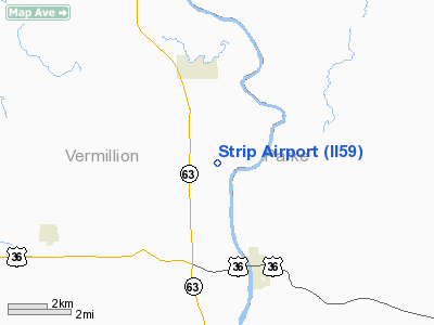
Location & QuickFacts
|
FAA
Information Effective: |
2008-06-05 |
|
Airport
Identifier: |
II59 |
| Airport
Status: |
Operational |
|
Longitude/Latitude: |
087-23-37.0580W/39-50-24.1370N
-87.393627/39.840038 (Estimated) |
|
Elevation: |
650
ft / 198.12 m (Estimated) |
|
Land: |
0 acres |
| From
nearest city: |
3
nautical miles N of Newport, IN |
|
Location: |
Vermillion County, IN |
|
Magnetic Variation: |
01W
(1985) |
Owner
& Manager
|
Ownership: |
Privately
owned |
|
Owner: |
Malcolm
H. Aukerman |
|
Address: |
Box 67
Newport,
IN 47966 |
|
Phone number: |
317-492-3350 |
|
Address: |
|
Airport Operations and Facilities
|
Airport
Use: |
Private |
|
Segmented
Circle: |
No |
| Control
Tower: |
No |
|
Sectional
chart: |
St Louis |
| Region: |
AGL
- Great Lakes |
|
Boundary
ARTCC: |
ZID - Indianapolis |
| Tie-in
FSS: |
HUF
- Terre Haute |
|
FSS Toll
Free: |
1-800-WX-BRIEF |
|
Runway Information
Runway 07/25
|
Dimension: |
1000 x 50 ft
/ 304.8 x 15.2 m |
|
Surface: |
TURF, |
|
|
Runway 07 |
Runway 25 |
| Traffic
Pattern: |
Left |
Left |
|
Obstruction: |
40 ft trees, 200.0 ft from runway |
40 ft trees, 200.0 ft from runway |
|
Radio Navigation Aids
|
ID |
Type |
Name |
Ch |
Freq |
Var |
Dist |
| PRG |
NDB |
Paris |
|
341.00 |
01E |
15.5
nm |
|
CFJ |
NDB |
Crawfordsville |
|
388.00 |
02W |
23.6 nm |
| HU |
NDB |
Yinno |
|
245.00 |
02W |
27.2
nm |
|
HMJ |
NDB |
Homer |
|
281.00 |
01E |
28.1 nm |
| TVX |
NDB |
Greencastle |
|
521.00 |
03W |
28.2
nm |
|
CZB |
NDB |
Casey |
|
359.00 |
00E |
42.8 nm |
| MT |
NDB |
Zebre |
|
347.00 |
00E |
43.3
nm |
|
SIV |
NDB |
Sullivan |
|
326.00 |
02W |
43.7 nm |
| FKR |
NDB |
Frankfort |
|
278.00 |
02W |
46.2
nm |
|
MTO |
VOR/DME |
Mattoon |
031X |
109.40 |
03E |
46.7 nm |
| TTH |
VORTAC |
Terre
Haute |
100X |
115.30 |
02E |
22.1
nm |
|
DNV |
VORTAC |
Danville |
047X |
111.00 |
02E |
28.3 nm |
| CMI |
VORTAC |
Champaign |
037X |
110.00 |
03E |
42.3
nm |
|
BVT |
VORTAC |
Boiler |
098X |
115.10 |
01E |
45.5 nm |
| VHP |
VORTAC |
Brickyard |
110X |
116.30 |
01E |
47.4
nm |
Remarks
- OWNER
DESIRES AIRPORT NOT TO BE CHARTED.
- FILED
FOR RECORD PURPOSES ONLY.
Based Aircraft
|
Aircraft
based on field: |
1 |
|
Single Engine Airplanes: |
1 |
Strip Airport
Address:
Vermillion County, IN
Tel:
317-492-3350
Images
and information placed above are from
http://www.airport-data.com/airport/II59/
We
thank them for the data!
| General
Info |
| Country |
United
States |
| State |
INDIANA
|
| FAA ID |
II59 |
| Latitude |
39-50-24.137N
|
| Longitude |
087-23-37.058W
|
| Elevation |
650 feet
|
| Near City |
NEWPORT
|
We don't guarantee the information is fresh and accurate. The data may
be wrong or outdated.
For more up-to-date information please refer to other sources.
|
|


