 |
|
|
|
|
|
Location & QuickFacts
|
FAA
Information Effective: |
2008-06-05 |
|
Airport
Identifier: |
OXI |
| Airport
Status: |
Operational |
|
Longitude/Latitude: |
086-39-53.3000W/41-19-48.7000N
-86.664806/41.330194 (Estimated) |
|
Elevation: |
685
ft / 208.79 m (Surveyed) |
|
Land: |
471 acres |
| From
nearest city: |
3
nautical miles NW of Knox, IN |
|
Location: |
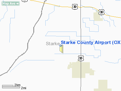
Starke County, IN |
|
Magnetic Variation: |
01W
(1980) |
Owner
& Manager
|
Ownership: |
Publicly
owned |
|
Owner: |
Starke
County Arpt Auth |
|
Address: |
1795 N. 200 E.
Knox, IN 46534 |
|
Phone number: |
574-772-5001 |
|
Manager: |
Pam Beharry |
|
Address: |
1795
N 200 E
Knox, IN 46534 |
|
Phone
number: |
574-772-5001 |
Airport Operations and Facilities
|
Airport
Use: |
Open
to public |
|
Wind indicator: |
Yes |
|
Segmented Circle: |
Yes |
|
Control
Tower: |
No |
| Lighting
Schedule: |
DUSK-DAWN |
|
Beacon Color: |
Clear-Green (lighted land airport) |
| Landing
fee charge: |
No |
|
Sectional
chart: |
Chicago |
| Region: |
AGL
- Great Lakes |
|
Boundary
ARTCC: |
ZAU - Chicago |
| Tie-in
FSS: |
HUF
- Terre Haute |
|
FSS on Airport: |
No |
| FSS
Toll Free: |
1-800-WX-BRIEF |
|
NOTAMs Facility: |
HUF (NOTAM-d service avaliable) |
|
Federal Agreements: |
NGY |
Airport
Communications
|
CTAF: |
122.800 |
|
Unicom: |
122.800
|
Airport Services
|
Fuel
available: |
100LL
100LL SELF SERVICE |
|
Airframe
Repair: |
MAJOR |
|
Power
Plant Repair: |
MAJOR
FOR MAINT CTC 574-772-7700. |
| Bottled
Oxygen: |
NONE |
|
Bulk Oxygen: |
NONE |
|
Runway Information
Runway 09/27
|
Dimension: |
3096 x 145 ft
/ 943.7 x 44.2 m |
|
Surface: |
TURF, Good Condition |
|
|
Runway 09 |
Runway 27 |
| Longitude: |
086-40-26.6420W |
086-39-46.0616W |
|
Latitude: |
41-19-47.7338N |
41-19-47.4884N |
| Elevation: |
680.00
ft |
682.00
ft |
|
Alignment: |
90 |
127 |
| Traffic
Pattern: |
Left |
Left |
|
Displaced
threshold: |
285.00 ft |
0.00 ft |
|
Obstruction: |
10
ft crops
RY 09 GLIDE PATH TO DISP THLD 29:1. |
30
ft pline, 985.0 ft from runway, 32:1 slope to clear |
|
Runway 18/36
|
Dimension: |
4401 x 75 ft
/ 1341.4 x 22.9 m |
| Surface: |
ASPH,
Good Condition |
|
Weight Limit: |
Single wheel: 30000 lbs. |
| Edge
Lights: |
Medium |
|
|
Runway 18 |
Runway 36 |
|
Longitude: |
086-39-44.0961W |
086-39-44.0654W |
| Latitude: |
41-20-11.2011N |
41-19-27.7219N |
|
Elevation: |
683.00 ft |
684.00 ft |
| Alignment: |
127 |
127 |
|
Traffic Pattern: |
Right |
Left |
| Markings: |
Non-precision
instrument, Good Condition |
Non-precision
instrument, Good Condition |
|
Crossing Height: |
24.00 ft |
24.00 ft |
| VASI: |
2-light
PAPI on left side |
2-light
PAPI on left side |
|
Visual Glide
Angle: |
3.00° |
3.00° |
| Runway
End Identifier: |
Yes |
Yes |
|
Obstruction: |
14 ft road, 850.0 ft from runway, 46:1 slope
to clear |
71 ft tree, 2250.0 ft from runway, 28:1 slope
to clear |
|
Radio Navigation Aids
|
ID |
Type |
Name |
Ch |
Freq |
Var |
Dist |
| IUL |
NDB |
La
Porte |
|
356.00 |
03W |
11.2
nm |
|
VP |
NDB |
Sedly |
|
212.00 |
02W |
12.0 nm |
| CPB |
NDB |
Culver |
|
391.00 |
01W |
14.4
nm |
|
RWN |
NDB |
Winamac/dcmsnd |
|
335.00 |
00W |
14.5 nm |
| MGC |
NDB |
Michigan
City |
|
203.00 |
01W |
23.7
nm |
|
RCR |
NDB |
Rochester |
|
216.00 |
03W |
26.7 nm |
| RZL |
NDB |
Rensselaer |
|
362.00 |
02W |
32.9
nm |
|
MCX |
NDB |
White County |
|
377.00 |
03W |
37.5 nm |
| GGP |
NDB |
Logansport |
|
263.00 |
01W |
39.6
nm |
|
OXI |
VOR/DME |
Knox |
103X |
115.60 |
00E |
0.9 nm |
| GIJ |
VORTAC |
Gipper |
101X |
115.40 |
00E |
30.6
nm |
|
GSH |
VORTAC |
Goshen |
084X |
113.70 |
00E |
31.0 nm |
| CGT |
VORTAC |
Chicago
Heights |
089X |
114.20 |
02E |
42.3
nm |
|
GUS |
VORTAC |
Grissom |
21Y |
108.45 |
02W |
47.3 nm |
Remarks
- PROVIDED
ALL TFC PAT OPERS ARE CONDUCTED ON THE W SIDE OF N/S RWY & ON THE
N SIDE OF E/W RWY.
Based Aircraft
|
Aircraft
based on field: |
17 |
|
Single Engine Airplanes: |
15 |
| Multi
Engine Airplanes: |
2 |
Operational Statistics
Time
Period: 2005-08-11 - 2006-08-10
|
Aircraft
Operations: |
294/Week |
| Air
Taxi: |
3.0% |
|
General Aviation
Local: |
34.0% |
| General
Aviation Itinerant: |
63.0% |
Starke County Airport
Address:
Starke County, IN
Tel:
574-772-5001
Images
and information placed above are from
http://www.airport-data.com/airport/OXI/
We
thank them for the data!
| General
Info |
| Country |
United
States |
| State |
INDIANA
|
| FAA ID |
OXI |
| Latitude |
41-19-48.675N
|
| Longitude |
086-39-53.035W
|
| Elevation |
684 feet
|
| Near City |
KNOX |
We don't guarantee the information is fresh and accurate. The data may
be wrong or outdated.
For more up-to-date information please refer to other sources.
|
|


