 |
|
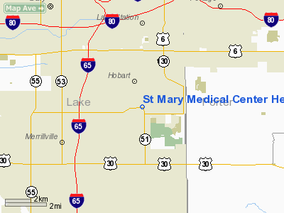
St Mary Medical Center Heliport |
Location & QuickFacts
|
FAA
Information Effective: |
2008-06-05 |
|
Airport
Identifier: |
00IN |
| Airport
Status: |
Operational |
|
Longitude/Latitude: |
087-15-38.0000W/41-30-41.0000N
-87.260556/41.511389 (Estimated) |
|
Elevation: |
634
ft / 193.24 m (Estimated) |
|
Land: |
0 acres |
| From
nearest city: |
2
nautical miles SW of Hobart, IN |
|
Location: |
Lake County, IN |
|
Magnetic Variation: |
02W
(1995) |
Owner & Manager
|
Ownership: |
Privately
owned |
| Owner: |
St
Marys Medical Center |
|
Address: |
1500 S Lake Park Ave
Hobart,
IN 46342 |
| Phone
number: |
219-942-0551 |
|
Manager: |
Ken Vanderhye |
| Address: |
St
Mary Medical Center, 1500 S Lake Park Ave
Hobart, IN 46342 |
|
Phone
number: |
219-942-0551 |
Airport
Operations and Facilities
|
Airport
Use: |
Private |
|
Wind indicator: |
Yes |
|
Segmented Circle: |
No |
|
Control
Tower: |
No |
| Lighting
Schedule: |
PHONE
REQ
FOR PERIMETER LGTS CALL 219-942-0551. |
|
Sectional
chart: |
Chicago |
| Region: |
AGL
- Great Lakes |
|
Boundary
ARTCC: |
ZAU - Chicago |
| Tie-in
FSS: |
HUF
- Terre Haute |
|
FSS Toll
Free: |
1-800-WX-BRIEF |
|
Runway Information
Helipad H1
|
Dimension: |
40 x 40 ft /
12.2 x 12.2 m |
|
Surface: |
MATS, |
|
|
Runway H1 |
Runway |
| Traffic
Pattern: |
Left |
Left |
|
Radio Navigation Aids
|
ID |
Type |
Name |
Ch |
Freq |
Var |
Dist |
| VP |
NDB |
Sedly |
|
212.00 |
02W |
17.6
nm |
|
IUL |
NDB |
La Porte |
|
356.00 |
03W |
22.0 nm |
| MGC |
NDB |
Michigan
City |
|
203.00 |
01W |
23.2
nm |
|
MX |
NDB |
Kedzi |
|
248.00 |
01W |
23.7 nm |
| HK |
NDB |
Ermin |
|
332.00 |
01W |
28.7
nm |
|
RZL |
NDB |
Rensselaer |
|
362.00 |
02W |
34.1 nm |
| RWN |
NDB |
Winamac/dcmsnd |
|
335.00 |
00W |
38.8
nm |
|
CPB |
NDB |
Culver |
|
391.00 |
01W |
43.3 nm |
| ME |
NDB |
Deana |
|
350.00 |
00E |
44.0
nm |
|
OXI |
VOR/DME |
Knox |
103X |
115.60 |
00E |
29.8 nm |
| IKK |
VOR/DME |
Kankakee |
053X |
111.60 |
00E |
37.4
nm |
|
ORD |
VOR/DME |
Chicago O'hare |
086X |
113.90 |
02E |
40.7 nm |
| CGT |
VORTAC |
Chicago
Heights |
089X |
114.20 |
02E |
14.0
nm |
|
EON |
VORTAC |
Peotone |
079X |
113.20 |
02E |
28.0 nm |
| GIJ |
VORTAC |
Gipper |
101X |
115.40 |
00E |
45.1
nm |
|
JOT |
VORTAC |
Joliet |
070X |
112.30 |
02E |
47.6 nm |
| MDW |
VOT |
Chicago
Midway |
|
111.00 |
|
27.6
nm |
|
ORD |
VOT |
Chicago O'hare Intl |
|
112.00 |
|
40.5 nm |
Remarks
- SEE
AIRSPACE CASE 99-AGL-491-NRA
St Mary Medical Center Heliport
Address:
Lake County, IN
Tel:
219-942-0551
Images
and information placed above are from
http://www.airport-data.com/airport/00IN/
We
thank them for the data!
| General
Info |
| Country |
United
States |
| State |
INDIANA
|
| FAA ID |
00IN |
| Latitude |
41-30-41.000N
|
| Longitude |
087-15-38.000W
|
| Elevation |
634 feet
|
| Near City |
HOBART
|
We don't guarantee the information is fresh and accurate. The data may
be wrong or outdated.
For more up-to-date information please refer to other sources.
|
|


