 |
|
|
|
|
|
Location & QuickFacts
|
FAA
Information Effective: |
2008-06-05 |
|
Airport
Identifier: |
2IN8 |
| Airport
Status: |
Operational |
|
Longitude/Latitude: |
087-22-08.0000W/41-23-40.0000N
-87.368889/41.394444 (Estimated) |
|
Elevation: |
758
ft / 231.04 m (Estimated) |
|
Land: |
0 acres |
| From
nearest city: |
0
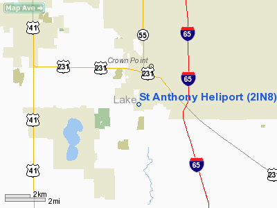
nautical miles S of Crown Point, IN |
|
Location: |
Lake County, IN |
|
Magnetic Variation: |
01W
(1985) |
Owner & Manager
|
Ownership: |
Privately
owned |
| Owner: |
St
Anthony Med Ctr Inc |
|
Address: |
Main At Franciscan Rd
Crown Point, IN 46307 |
| Phone
number: |
219-663-8120 |
|
Manager: |
Richard T. Maryonvich |
| Address: |
1201
South Main
Crown Point, IN 46307-8483 |
|
Phone
number: |
219-738-2100 |
Airport
Operations and Facilities
|
Airport
Use: |
Private
MEDICAL USE. |
|
Wind indicator: |
Yes |
|
Segmented Circle: |
No |
|
Control
Tower: |
No |
| Lighting
Schedule: |
PHONE
REQ
FOR ROTATING BEACON PHONE 219-738-2100 OR 219-663-8120. |
|
Beacon Color: |
Clear-Green-Yellow (heliport) |
|
Sectional chart: |
Chicago |
|
Region: |
AGL - Great Lakes |
| Boundary
ARTCC: |
ZAU
- Chicago |
|
Tie-in FSS: |
HUF - Terre Haute |
| FSS
on Airport: |
No |
|
FSS Toll
Free: |
1-800-WX-BRIEF |
|
Runway Information
Helipad H1
|
Dimension: |
50 x 50 ft
/ 15.2 x 15.2 m
HELIPAD WITHIN 140 FT X 140 FT LNDG/TKOF AREA. |
|
Surface: |
ASPH, |
|
|
Runway H1 |
Runway |
| Traffic
Pattern: |
Left |
Left |
|
Radio Navigation Aids
|
ID |
Type |
Name |
Ch |
Freq |
Var |
Dist |
| VP |
NDB |
Sedly |
|
212.00 |
02W |
22.4
nm |
|
MX |
NDB |
Kedzi |
|
248.00 |
01W |
25.4 nm |
| IUL |
NDB |
La
Porte |
|
356.00 |
03W |
27.6
nm |
|
RZL |
NDB |
Rensselaer |
|
362.00 |
02W |
28.2 nm |
| HK |
NDB |
Ermin |
|
332.00 |
01W |
28.7
nm |
|
MGC |
NDB |
Michigan City |
|
203.00 |
01W |
31.2 nm |
| RWN |
NDB |
Winamac/dcmsnd |
|
335.00 |
00W |
39.0
nm |
|
ME |
NDB |
Deana |
|
350.00 |
00E |
45.4 nm |
| CPB |
NDB |
Culver |
|
391.00 |
01W |
45.7
nm |
|
MCX |
NDB |
White County |
|
377.00 |
03W |
49.5 nm |
| IKK |
VOR/DME |
Kankakee |
053X |
111.60 |
00E |
29.0
nm |
|
OXI |
VOR/DME |
Knox |
103X |
115.60 |
00E |
32.8 nm |
| ORD |
VOR/DME |
Chicago
O'hare |
086X |
113.90 |
02E |
43.0
nm |
|
CGT |
VORTAC |
Chicago Heights |
089X |
114.20 |
02E |
11.5 nm |
| EON |
VORTAC |
Peotone |
079X |
113.20 |
02E |
20.5
nm |
|
JOT |
VORTAC |
Joliet |
070X |
112.30 |
02E |
43.7 nm |
| MDW |
VOT |
Chicago
Midway |
|
111.00 |
|
29.2
nm |
|
ORD |
VOT |
Chicago O'hare Intl |
|
112.00 |
|
42.8 nm |
Remarks
- APCH/DEP
082 CLKWS 215; AREA IS MARKED; WIND INDICATOR IS MAINTAINED; COMPLY
WITH FAR PART 91.126(B)(2); 6 LGT POLIES ARE REMOVED; LGTS INSTALLED
ON POLES AT 217 DEG; 260 DEGS; 328 DEGS; WIRES BETWEEN 217 DEGS &
328 DEGS ARE MKD WITH BALLS.
St Anthony Heliport
Address:
Lake County, IN
Tel:
219-663-8120,
219-738-2100
Images
and information placed above are from
http://www.airport-data.com/airport/2IN8/
We
thank them for the data!
| General
Info |
| Country |
United
States |
| State |
INDIANA
|
| FAA ID |
2IN8 |
| Latitude |
41-23-40.000N
|
| Longitude |
087-22-08.000W
|
| Elevation |
758 feet
|
| Near City |
CROWN
POINT |
We don't guarantee the information is fresh and accurate. The data may
be wrong or outdated.
For more up-to-date information please refer to other sources.
|
|


