 |
|
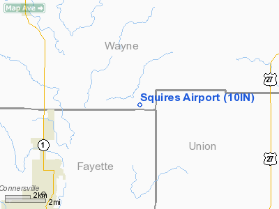
Location & QuickFacts
|
FAA
Information Effective: |
2008-06-05 |
|
Airport
Identifier: |
10IN |
| Airport
Status: |
Operational |
|
Longitude/Latitude: |
085-02-55.8660W/39-43-06.1690N
-85.048852/39.718380 (Estimated) |
|
Elevation: |
1000
ft / 304.80 m (Estimated) |
|
Land: |
0 acres |
| From
nearest city: |
6
nautical miles NE of Connersville, IN |
|
Location: |
Wayne County, IN |
|
Magnetic Variation: |
03W
(1985) |
Owner
& Manager
|
Ownership: |
Privately
owned |
|
Owner: |
Donald
Squires |
|
Address: |
Rr 1
Brownsville, IN 47325 |
|
Phone number: |
317-825-1243 |
|
Address: |
|
Airport
Operations and Facilities
|
Airport Use: |
Private |
|
Wind indicator: |
Yes |
|
Segmented Circle: |
No |
|
Control
Tower: |
No |
|
Landing fee charge: |
No |
|
Sectional
chart: |
St Louis |
|
Region: |
AGL
- Great Lakes |
|
Boundary
ARTCC: |
ZID - Indianapolis |
|
Tie-in FSS: |
HUF
- Terre Haute |
|
FSS on
Airport: |
No |
|
FSS Toll Free: |
1-800-WX-BRIEF |
Airport
Services
|
Airframe
Repair: |
NONE |
|
Power
Plant Repair: |
NONE |
|
Runway Information
Runway 18/36
|
Dimension: |
2600 x 100 ft
/ 792.5 x 30.5 m |
| Surface: |
TURF,
|
|
|
Runway 18 |
Runway 36 |
|
Traffic Pattern: |
Left |
Left |
|
Obstruction: |
|
50
ft pline |
|
Helipad H1
|
Dimension: |
40 x 20 ft /
12.2 x 6.1 m |
| Surface: |
CONC,
|
|
|
Runway H1 |
Runway |
|
Traffic Pattern: |
Left |
Left |
|
Radio Navigation Aids
|
ID |
Type |
Name |
Ch |
Freq |
Var |
Dist |
| UWL |
NDB |
New
Castle |
|
385.00 |
02W |
15.8
nm |
|
OXD |
NDB |
Oxford |
|
282.00 |
04W |
17.7 nm |
| HLB |
NDB |
Batesville |
|
254.00 |
02W |
24.2
nm |
|
AI |
NDB |
Video |
|
371.00 |
03W |
30.0 nm |
| HAO |
NDB |
Hamilton |
|
260.00 |
04W |
30.3
nm |
|
HKF |
NDB |
Hook Field |
|
239.00 |
04W |
30.8 nm |
| VES |
NDB |
Versailles |
|
356.00 |
04W |
38.0
nm |
|
ISZ |
NDB |
Cincinnati-blue Ash |
|
388.00 |
04W |
41.6 nm |
| UR |
NDB |
Burln |
|
321.00 |
04W |
42.4
nm |
|
BA |
NDB |
Clifs |
|
410.00 |
03W |
42.9 nm |
| MDE |
NDB |
Madeira |
|
379.00 |
04W |
43.9
nm |
|
PLD |
NDB |
Portland |
|
257.00 |
03W |
44.3 nm |
| LUK |
NDB |
Cincinnati |
|
335.00 |
04W |
47.0
nm |
|
OVO |
NDB |
North Vernon |
|
374.00 |
02W |
47.7 nm |
| UMP |
NDB |
Metropolitan |
|
338.00 |
03W |
48.1
nm |
|
HFY |
NDB |
Greenwood |
|
398.00 |
02W |
48.5 nm |
| FFO |
TACAN |
Patterson |
099X |
|
04W |
46.3
nm |
|
MIE |
VOR/DME |
Muncie |
091X |
114.40 |
03W |
35.0 nm |
| DQN |
VOR/DME |
Dayton |
092X |
114.50 |
01W |
35.0
nm |
|
RID |
VORTAC |
Richmond |
043X |
110.60 |
03W |
10.0 nm |
| SHB |
VORTAC |
Shelbyville |
057X |
112.00 |
01E |
36.2
nm |
|
CVG |
VORTAC |
Cincinnati |
120X |
117.30 |
04W |
45.2 nm |
| DAY |
VOT |
Dayton J M Cox-day |
|
111.00 |
|
39.8
nm |
|
LUK |
VOT |
Cincinnati Muni/lunken |
|
108.40 |
|
47.1 nm |
Remarks
- APP/DEP
RTES FM 360 DEG & 100-120 DEG, HELIPAD APRPLY MKD & WIND INDCR
MAINTD.
Based Aircraft
|
Aircraft
based on field: |
4 |
|
Single Engine Airplanes: |
3 |
| Helicopters: |
1 |
Squires Airport
Address:
Wayne County, IN
Tel:
317-825-1243
Images
and information placed above are from
http://www.airport-data.com/airport/10IN/
We
thank them for the data!
| General
Info |
| Country |
United
States |
| State |
INDIANA
|
| FAA ID |
10IN |
| Latitude |
39-43-06.169N
|
| Longitude |
085-02-55.866W
|
| Elevation |
1000 feet
|
| Near City |
CONNERSVILLE
|
We don't guarantee the information is fresh and accurate. The data may
be wrong or outdated.
For more up-to-date information please refer to other sources.
|
|


