|
|
South Bend Regional Airport |
| South Bend Regional Airport |
 |
 |
| IATA: SBN â ICAO: KSBN â FAA LID: SBN |
| Summary |
| Airport type |
Public |
| Owner |
St. Joseph County Airport Authority |
| Serves |
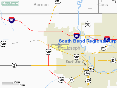
South Bend, Indiana, USA |
| Elevation AMSL |
799 ft / 244 m |
| Coordinates |
41°42â²30â³N 086°19â²02â³W / 41.70833°N 86.31722°W / 41.70833; -86.31722Coordinates: 41°42â²30â³N 086°19â²02â³W / 41.70833°N 86.31722°W / 41.70833; -86.31722 |
| Website |
www.SBNair.com |
| Runways |
| Direction |
Length |
Surface |
| ft |
m |
| 9L/27R |
4,300 |
1,311 |
Asphalt |
| 9R/27L |
8,414 |
2,565 |
Asphalt |
| 18/36 |
7,100 |
2,164 |
Asphalt |
| Statistics (2009) |
| Aircraft operations |
40,515 |
| Based aircraft |
46 |
| Passenger volume |
910,512 |
| Source: Federal Aviation Administration |
FAA diagram of South Bend Regional Airport (SBN) South Bend Regional Airport (IATA: SBN, ICAO: KSBN, FAA LID: SBN) is a public airport located three miles (5 km) northwest of the central business district of South Bend, a city in St. Joseph County, Indiana, United States. This airport is publicly owned by St. Joseph County Airport Authority. It is the state's second busiest airport in terms of commercial traffic after Indianapolis International Airport.
The airport has been known in the past as Bendix Field, St. Joseph County Airport and Michiana Regional Transportation Center. The airport was renamed South Bend Regional Airport to help identify the airport's location since many travelers were unaware of the meaning or location of Michiana (taken from MICHigan and IndIANA). Administration
South Bend Regional Airport is one of only a few multi-modal transportation facilities in America that provides air, interstate bus and interstate rail service from one multi-modal terminal facility. The St. Joseph County Airport Authority claims the airport was the first truly multi-modal airport in the country.
The St. Joseph County Airport Authority is the administrative body over the airport and also provides police, fire and medical protection to the airport and its occupants. The members of the airport safety department are cross-trained as State-certified law enforcement officers, State-certified paramedics/EMTs and State-certified firefighters. The airport has been directed by John C. Schalliol for more than 25 years.
Facilities
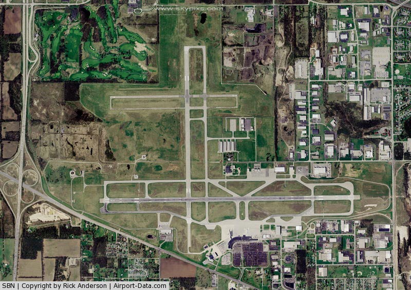
Runway 18/36 re-opened in 3rd quarter 2007 at a new length of 7,100 feet. Also, runway connector N3 was reopened after over a decade of being closed.
The terminal has two concourses, A and C. Concourse A has 6 gates, 3 of which have ground-level boarding bridges. Concourse C has 5 gates, one of which as a ground-level boarding bridge (currently being used by Allegiant Air). All boarding bridges are full-size and capable of accommodating most commercial aircraft today. Gate A-6 had a ground-level boarding bridge in the 1990s, but it has since been removed.
The airport's concourses have what are known as hold rooms. These vary slightly from some airports that have seating areas specific to a gate. Hold Room A serves all gate areas in Concourse A, and Hold Room C serves all gate areas in Concourse C.
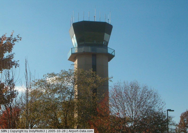
South Bend Regional Airport has an in-terminal viewing area with live air traffic control transmissions from South Bend Air Traffic Control Tower/TRACON. The viewing area is located on the second level of the terminal's atrium.
In a press release issued in March 2008 the St. Joseph County Airport Authority announced plans for a 2 story, 45,000 square foot, 11.8-million dollar expansion of Concourse A that will include 5 new jet bridges (bringing to total number of gates post-expansion to 9), a Dining Room, a concession area/lounge, gift shops, childrenâs play area as well as a business center. The Dining Room and Lounge will feature deli meals, snacks and drinks similar to the existing airport services as well as beverages and snacks already screened to take along on outbound flights. The current Concourse C will be demolished and all passenger screening will be consolidated into one location at the existing Concourse A. Construction on the expansion will begin in late 2009 with completion by 2011. When the expansion is complete each gate will have a jetway except A1 as well have its own dedicated seating area.
Airport operations
Within the state of Indiana, the airport is second only to Indianapolis by means of passenger movements and air carrier service. In fact, according to the airport authority, South Bend is ranked in the top 25 percent of small-to-medium sized airports in terms of air service. The airport falls to third place behind Indianapolis and Fort Wayne in cargo operations, and fifth in the state for overall take-offs and landings. Due to South Bend's proximity to Chicago, South Bend air traffic controllers work closely with Chicago Center and Chicago Approach Control to sequence aircraft into and out of Chicago's terminal airspace. These efforts make South Bend's Tower/TRACON the second busiest terminal air traffic facility in the state.
Air service
Allegiant Air announced in March 2008 interest in providing direct international service between South Bend and Cancun, Mexico. The airport authority told the public in a press release that now is the time to prepare for the service, not later, due to the amount of time it will take to get the customs facility operational, which could be a few years.
This is not the first time an airline has expressed interest in bringing international flights to South Bend. In the early 2000s Air Canada's Air Georgian announced plans for international (trans-border) service between South Bend and Toronto. That service never took off due to South Bend not being able to obtain a customs facility.
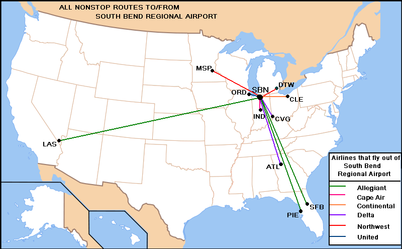
Airlines and destinations
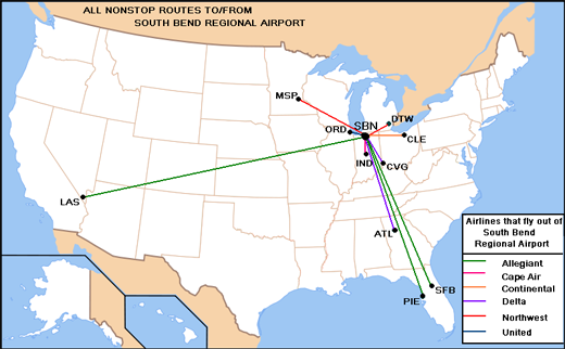 |
Airlines & Destinations served from
South Bend Regional Airport
(As of 2008)
|
| Airlines |
Destinations |
Concourse |
| Allegiant Air |
Las Vegas, Orlando-Sanford, Phoenix/Mesa, St. Petersburg/Clearwater |
C |
| Continental Connection operated by CommutAir |
Cleveland |
A |
| Delta Connection operated by Atlantic Southeast Airlines |
Atlanta |
A |
| Delta Connection operated by Chautauqua Airlines |
Cincinnati/Northern Kentucky |
A |
| Delta Connection operated by Pinnacle Airlines |
Detroit, Minneapolis/St. Paul |
A |
| Delta Connection operated by Mesaba Airlines |
Detroit |
A |
| United Express operated by Mesa Airlines |
Chicago-O'Hare |
A |
| United Express operated by SkyWest Airlines |
Chicago-O'Hare |
A |
| United Express operated by Trans States Airlines |
Chicago-O'Hare |
A |
Incidents
- On the evening of July 18, 2007, lightning struck the airfield, causing the runway lights to turn off. Planes en route to South Bend were diverted elsewhere, and all flights planned to take off to/from South Bend were canceled. Planes were still not able to take off in the morning of July 19 because the lights had not been fixed and it was still dark out. As a result, many flights were canceled, and passengers were put on different flights. Later that day, the lights were fixed, and flights resumed their normal schedules.
The above content comes from Wikipedia and is published under free licenses – click here to read more.
|
 |
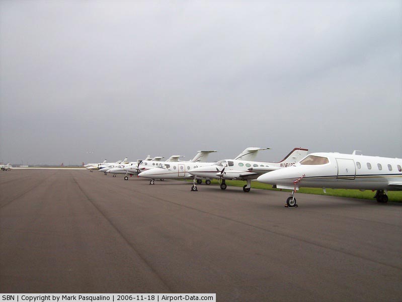
(Click on the photo to enlarge) |
|
 |
(Click on the photo to enlarge) |
|
 |
(Click on the photo to enlarge) |
|
 |
(Click on the photo to enlarge) |
Location & QuickFacts
|
FAA
Information Effective: |
2008-06-05 |
|
Airport
Identifier: |
SBN |
| Airport
Status: |
Operational |
|
Longitude/Latitude: |
086-19-02.4209W/41-42-29.6025N
-86.317339/41.708223 (Estimated) |
|
Elevation: |
799
ft / 243.54 m (Surveyed) |
|
Land: |
2200 acres |
| From
nearest city: |
3
nautical miles NW of South Bend, IN |
|
Location: |
St Joseph County, IN |
|
Magnetic Variation: |
03W
(1985) |
Owner & Manager
|
Ownership: |
Publicly
owned |
| Owner: |
St
Joseph Cnty Arpt Authority |
|
Address: |
4477 Progress Drive, South Bend Regional
Airport
South Bend, IN 46628 |
| Phone
number: |
574-233-2185 |
|
Manager: |
John Schalliol |
| Address: |
4477
Progress Drive, South Bend Regional Airport
South Bend, IN 46628 |
|
Phone
number: |
574-233-2185 |
Airport
Operations and Facilities
|
Airport
Use: |
Open
to public |
|
Wind indicator: |
Yes |
|
Segmented Circle: |
No |
|
Control
Tower: |
Yes |
| Lighting
Schedule: |
DUSK-DAWN
WHEN ATCT CLSD HIRL RY 09R/27L PRESET MED & RY 18/36
PRESET LOW; ACTVT MALSF RY 09R; MALSR RY 27L - CTAF. |
|
Beacon Color: |
Clear-Green (lighted land airport) |
|
Sectional chart: |
Chicago |
|
Region: |
AGL - Great Lakes |
| Traffic
Pattern Alt: |
1000
ft |
|
Boundary
ARTCC: |
ZAU - Chicago |
| Tie-in
FSS: |
HUF
- Terre Haute |
|
FSS on Airport: |
No |
| FSS
Toll Free: |
1-800-WX-BRIEF |
|
NOTAMs Facility: |
SBN (NOTAM-d service avaliable) |
|
Certification type/date: |
I
B S 05/1973 |
|
Federal
Agreements: |
N |
Airport
Communications
|
CTAF: |
118.900 |
|
Unicom: |
122.950
|
Airport
Services
|
Fuel
available: |
100LLA |
|
Airframe
Repair: |
MAJOR |
|
Power
Plant Repair: |
MAJOR |
|
Runway Information
Runway 09L/27R
|
Dimension: |
4300 x 75 ft
/ 1310.6 x 22.9 m |
| Surface: |
ASPH,
Good Condition |
|
Weight Limit: |
Dual wheel: 60000 lbs. |
| Edge
Lights: |
Medium |
|
|
Runway 09L |
Runway 27R |
|
Longitude: |
086-19-43.6022W |
086-18-46.9228W |
| Latitude: |
41-42-50.1992N |
41-42-51.0964N |
|
Elevation: |
788.00 ft |
780.00 ft |
| Alignment: |
89 |
127 |
|
Traffic Pattern: |
Left |
Left |
| Markings: |
Non-precision
instrument, Good Condition |
Non-precision
instrument, Good Condition |
|
Crossing Height: |
40.00 ft |
38.00 ft |
| VASI: |
2-light
PAPI on left side |
2-light
PAPI on left side |
|
Visual Glide
Angle: |
3.00° |
3.00° |
|
Obstruction: |
62
ft tree, 1541.0 ft from runway, 93 ft right of centerline,
21:1 slope to clear |
51
ft tree, 1226.0 ft from runway, 368 ft right of centerline,
20:1 slope to clear |
|
Runway 09R/27L
|
Dimension: |
8414 x 150 ft
/ 2564.6 x 45.7 m |
| Surface: |
ASPH,
Fair Condition |
|
Surface Treatment: |
Saw-cut or plastic Grooved
RY 18-/36 GROOVED NORTH OF RY 9R/27L. |
| Weight
Limit: |
Single wheel: 100000 lbs.
Dual wheel: 175000 lbs.
Dual
tandem wheel: 300000 lbs. |
|
Edge Lights: |
High |
|
|
Runway 09R |
Runway 27L |
| Longitude: |
086-19-45.9228W |
086-17-55.0289W |
|
Latitude: |
41-42-15.5726N |
41-42-17.3215N |
| Elevation: |
790.00
ft |
769.00
ft |
|
Alignment: |
89 |
127 |
| ILS
Type: |
ILS
|
ILS
|
|
Traffic Pattern: |
Left |
Left |
| Markings: |
Precision
instrument, Good Condition |
Precision
instrument, Good Condition |
|
Crossing Height: |
50.00 ft |
45.00 ft |
| VASI: |
4-light
PAPI on left side |
4-light
PAPI on left side |
|
Visual Glide
Angle: |
3.00° |
3.00° |
| RVR
Equipment: |
|
touchdown |
|
Approach lights: |
MALSF |
MALSR |
| Runway
End Identifier: |
No |
No |
|
Centerline
Lights: |
No |
No |
| Touchdown
Lights: |
No |
No |
|
Obstruction: |
60 ft tree, 1492.0 ft from runway, 666 ft right
of centerline, 21:1 slope to clear |
36 ft tree, 1741.0 ft from runway, 588 ft right
of centerline, 42:1 slope to clear |
|
Runway 18/36
|
Dimension: |
7100 x 150 ft
/ 2164.1 x 45.7 m |
|
Surface: |
ASPH, Fair Condition |
| Weight
Limit: |
Single wheel: 100000 lbs.
Dual wheel: 175000 lbs.
Dual
tandem wheel: 300000 lbs. |
|
Edge Lights: |
Medium |
|
|
Runway 18 |
Runway 36 |
| Longitude: |
086-19-09.8222W |
086-19-07.7762W |
|
Latitude: |
41-43-07.5096N |
41-41-57.3843N |
| Elevation: |
798.00
ft |
760.00
ft |
|
Alignment: |
127 |
127 |
| Traffic
Pattern: |
Left |
Left |
|
Markings: |
Non-precision instrument, Good Condition |
Basic, Good Condition |
| Crossing
Height: |
50.00
ft |
50.00
ft |
|
VASI: |
4-light PAPI on left side |
4-light PAPI on left side |
| Visual
Glide Angle: |
3.00° |
3.00° |
|
Runway End
Identifier: |
No |
No |
| Centerline
Lights: |
No |
No |
|
Touchdown
Lights: |
No |
No |
|
Obstruction: |
69
ft tree, 2726.0 ft from runway, 442 ft right of centerline,
36:1 slope to clear |
80
ft tree, 1880.0 ft from runway, 210 ft right of centerline,
20:1 slope to clear |
|
Radio Navigation Aids
|
ID |
Type |
Name |
Ch |
Freq |
Var |
Dist |
| MGC |
NDB |
Michigan
City |
|
203.00 |
01W |
22.4
nm |
|
IUL |
NDB |
La Porte |
|
356.00 |
03W |
24.0 nm |
| VP |
NDB |
Sedly |
|
212.00 |
02W |
29.5
nm |
|
CPB |
NDB |
Culver |
|
391.00 |
01W |
29.7 nm |
| HAI |
NDB |
Three
Rivers |
|
407.00 |
02W |
35.8
nm |
|
RCR |
NDB |
Rochester |
|
216.00 |
03W |
39.1 nm |
| RWN |
NDB |
Winamac/dcmsnd |
|
335.00 |
00W |
39.1
nm |
|
IRS |
NDB |
Sturgis |
|
382.00 |
04W |
40.1 nm |
| OLK |
VOR |
Wolf
Lake |
|
110.40 |
03W |
46.2
nm |
|
OXI |
VOR/DME |
Knox |
103X |
115.60 |
00E |
27.6 nm |
| ELX |
VOR/DME |
Keeler |
113X |
116.60 |
00E |
27.6
nm |
|
PMM |
VOR/DME |
Pullman |
058X |
112.10 |
00E |
46.5 nm |
| AZO |
VOR/DME |
Kalamazoo |
027X |
109.00 |
01W |
46.7
nm |
|
GIJ |
VORTAC |
Gipper |
101X |
115.40 |
00E |
3.6 nm |
| GSH |
VORTAC |
Goshen |
084X |
113.70 |
00E |
17.0
nm |
Remarks
- BIRDS
ON & INVOF ARPT.
- RY
09L/27R & TWYS J/J1/J2 & T NOT AVBL TO ACR OPNS WITH MORE THAN
30 PSGR SEATS.
- LINE-OF-SIGHT
BTN INTERSECTING RYS IS RESTRICTED.
- AIR
CARRIER RAMP CLSD TO GA ACFT OPNS. ACCESS TO AIR CARRIER RAMP AREA RESTRICTED
TO SCHEDULED COML ACFT AND UNSCHEDULED COML ACFT (DIVERSIONS)CHARTERS
USING LARGE ACFT. AUTHORIZED GROUND EQUIPMENT, RAMP PERSONNEL AND ALL
GA ACFT PARKING WILL BE ON FIXED BASE OPERATORS RAMP.
- TWY
B BTN B1 & B2 TWY RESTRICTED TO ACFT LARGER THAN B757 OR WINGSPAN
125' AND GREATER.
- HIGH
TENSION WIRES IN VICINITY OF 27R APPROACH. BE ALERT DURING RIGHT BASE
TO RWY 27R.
- 92'
HIGH TENSION WIRES 2160' FROM RWY 27R RWY END, 394' RIGHT OF RWY C/L.
APCH SLOPE 21:1
Based Aircraft
|
Aircraft
based on field: |
68 |
|
Single Engine Airplanes: |
52 |
| Multi
Engine Airplanes: |
8 |
|
Jet Engine Airplanes: |
7 |
| Helicopters: |
1 |
Major Carriers Serving This Airport
|
Mesa Airlines Inc. |
91.0% |
|
Comair Inc. |
9.0% |
Most Popular Destinations
|
Chicago O'hare
Intl (ORD) |
91.0% |
|
Cincinnati/northern
Kentucky Intl (CVG) |
8.4% |
|
Kalamazoo/battle
Creek Intl (AZO) |
0.6% |
Most Popular Aircraft
|
N75992 |
5.6% |
|
N75994 |
3.4% |
|
N75999 |
3.4% |
|
N570ML |
3.4% |
|
N154SF |
3.4% |
|
N75991 |
2.8% |
|
N47239 |
2.8% |
|
N592ML |
2.8% |
|
N77181 |
2.8% |
|
N75987 |
2.8% |
Operational Statistics
Time
Period: 2006-06-01 - 2007-05-31
|
Aircraft
Operations: |
149/Day |
| Commerical: |
37.5% |
|
Air Taxi: |
5.4% |
| General
Aviation Local: |
16.7% |
|
General Aviation
Itinerant: |
40.2% |
| Military: |
0.2% |
South Bend Regional Airport
Address:
St Joseph County, IN
Tel:
574-233-2185
Images
and information placed above are from
http://www.airport-data.com/airport/SBN/
We
thank them for the data!
| General
Info |
| Country |
United
States |
| State |
INDIANA
|
| FAA ID |
SBN |
| Latitude |
41-42-32.233N
|
| Longitude |
086-19-06.507W
|
| Elevation |
799 feet
|
| Near City |
SOUTH
BEND |
We don't guarantee the information is fresh and accurate. The data may
be wrong or outdated.
For more up-to-date information please refer to other sources.
|
|