 |
|
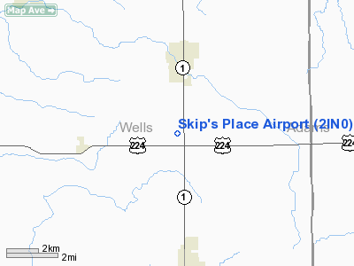
Location
& QuickFacts
|
FAA
Information Effective: |
2008-06-05 |
|
Airport
Identifier: |
2IN0 |
|
Airport
Status: |
Operational |
|
Longitude/Latitude: |
085-10-16.0000W/40-50-13.0000N
-85.171111/40.836944 (Estimated) |
|
Elevation: |
858 ft / 261.52 m (Estimated) |
|
Land: |
0 acres |
|
From nearest
city: |
2 nautical miles S of Ossian, IN |
|
Location: |
Wells County, IN |
|
Magnetic
Variation: |
04W (1995) |
Owner & Manager
|
Ownership: |
Privately
owned |
|
Owner: |
Harvey & Marie |
|
Address: |
6382 N Sr 1
Ossian, IN 46777 |
|
Phone
number: |
219-622-4211 |
|
Manager: |
Harvey & Marie Reichelt |
|
Address: |
6382 N Sr 1
Ossian, IN 46777 |
|
Phone
number: |
219-622-4211 |
Airport
Operations and Facilities
|
Airport
Use: |
Private |
|
Segmented
Circle: |
No |
|
Control
Tower: |
No |
|
Sectional
chart: |
Chicago |
|
Region: |
AGL - Great Lakes |
|
Boundary
ARTCC: |
ZAU - Chicago |
|
Tie-in
FSS: |
HUF - Terre Haute |
|
FSS Toll
Free: |
1-800-WX-BRIEF |
|
Runway Information
Runway 09/27
|
Dimension: |
2050 x 75 ft
/ 624.8 x 22.9 m |
|
Surface: |
TURF, |
|
|
Runway 09 |
Runway 27 |
|
Traffic
Pattern: |
Left |
Left |
|
Displaced
threshold: |
150.00 ft |
500.00 ft
RY 09/27 DSPLCD THLDS MKD WITH CONES. |
|
Obstruction: |
30 ft pole, 600.0 ft from runway |
30 ft pole, 900.0 ft from runway |
|
Radio Navigation
Aids
|
ID |
Type |
Name |
Ch |
Freq |
Var |
Dist |
|
HHG |
NDB |
Huntington |
|
417.00 |
03W |
13.4 nm |
|
PLD |
NDB |
Portland |
|
257.00 |
03W |
24.6 nm |
|
VFU |
NDB |
Stanley |
|
411.00 |
05W |
25.4 nm |
|
IWH |
NDB |
Wabash |
|
329.00 |
03W |
28.8 nm |
|
CQA |
NDB |
Lakefield |
|
205.00 |
04W |
34.9 nm |
|
DFI |
NDB |
Defiance |
|
246.00 |
05W |
45.1 nm |
|
VES |
NDB |
Versailles |
|
356.00 |
04W |
48.1 nm |
|
RCR |
NDB |
Rochester |
|
216.00 |
03W |
48.3 nm |
|
ANQ |
NDB |
Angola |
|
347.00 |
05W |
48.4 nm |
|
AI |
NDB |
Video |
|
371.00 |
03W |
48.7 nm |
|
OLK |
VOR |
Wolf Lake |
|
110.40 |
03W |
28.7 nm |
|
MZZ |
VOR/DME |
Marion |
023X |
108.60 |
03W |
31.0 nm |
|
MIE |
VOR/DME |
Muncie |
091X |
114.40 |
03W |
37.5 nm |
|
FWA |
VORTAC |
Fort Wayne |
125X |
117.80 |
00E |
8.6 nm |
|
OKK |
VORTAC |
Kokomo |
082X |
113.50 |
00E |
44.5 nm |
|
GUS |
VORTAC |
Grissom |
21Y |
108.45 |
02W |
46.1 nm |
|
FWA |
VOT |
Fort Wayne Baer |
|
111.00 |
|
8.5 nm |
Remarks
- PRVDD
A CLEAR 20:1 APCH, AREA 125 FT EITHER SIDE OF RY CNTRLN & 200 FT
OFF RY ENDS ARE CLEAR, AREA 60 FT EITHER SIDE OF RY CNTRLN & 240
FT OFF RY ENDS ARE CLEARED & NO RUTS.
Based Aircraft
|
Aircraft
based on field: |
1 |
|
Single Engine
Airplanes: |
1 |
Skip's Place Airport
Address:
Wells County, IN
Tel:
219-622-4211
Images
and information placed above are from
http://www.airport-data.com/airport/2IN0/
We
thank them for the data!
| General
Info |
| Country |
United
States |
| State |
INDIANA
|
| FAA ID |
2IN0 |
| Latitude |
40-50-13.000N
|
| Longitude |
085-10-16.000W
|
| Elevation |
858 feet
|
| Near City |
OSSIAN
|
We don't guarantee the information is fresh and accurate. The data may
be wrong or outdated.
For more up-to-date information please refer to other sources.
|
|


